Bioregions and their subregions typically contain many thousands of assets. The Galilee subregion within the Lake Eyre Basin bioregion, for example, has over 4,000 assets comprised of over 800,000 individual spatially discrete elements (individual spatial features – points, lines and polygons). Similarly, in the Namoi subregion, ecological assets alone exceed 1,800 assets comprised of over 34,000 discrete spatial elements. Many assets have internal heterogeneity or complexity that may influence receptor assignment. For example, a single national park could contain many water-dependent assets including rivers, floodplains, lakes, wetlands and springs, and habitats for a range of threatened species. Given the extremely high number of potential interdependencies, it is impractical to develop receptor impact models for each individual asset.
To overcome this constraint a landscape classification approach is used to systematically define geographical areas into classes that are similar in physical and/or biological and hydrological character. This is a form of ecosystem classification relevant to each BA and, importantly, includes human ecosystems, such as rural and urban areas. Conceptually, the landscape classes can be considered as types of ecosystem asset (Bureau of Meteorology, 2013; United Nations et al., 2014) but are referred to as landscape classes in BAs. An ecosystem asset is an ecosystem that may provide benefits to humanity. Landscape classification aims to:
- reduce asset complexity to a limited number of regional-scale landscape classes (e.g. 10 to 20) appropriate for the Assessment that are mutually exclusive and comprehensive such that all assets in a BA are a member of at least one landscape class
- wherever possible, use existing data sources and classifications (e.g. River Styles, Australian National Aquatic Ecosystem (ANAE) (Aquatic Ecosystems Task Group, 2012), etc.)
- guide the development and review of conceptual models for selection of appropriate hydrological response variables and receptor impact variables associated with water-dependent asset
- provide a natural aggregation for reporting risk and impacts in Component 3 and Component 4 (Figure 2).
While one aim of the landscape classification is to focus the contextual information for the subregion or bioregion, the capacity to classify water-dependent ecosystems within a broader landscape will vary from one subregion or bioregion to another depending on the availability of underpinning datasets. To facilitate classification, the approach should wherever possible use existing information, and be based on existing classifications (Table 3). A diagrammatic representation of the underlying rationale for the landscape classification approach is shown in Figure 9.
The starting point in developing the landscape classification is the information in the context statement for the subregion or bioregion (product 1.1). The context statement summarises existing knowledge of geology, hydrology, hydrogeology, geography and ecology prior to the new model-data analysis for the Assessment. It also provides insights into the important drivers of variability in geology, climate, soils, vegetation and land use that make up the unique character of the subregion or bioregion.
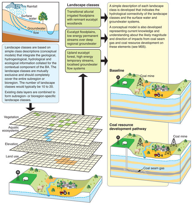
Figure 9 Overview of the approach for classifying unique landscape systems
M05 is companion submethodology (as listed in Table 1) for developing a conceptual model for causal pathways (Henderson et al., 2016).
The primary outcome of the landscape classification is a set of landscape classes that represents areas of similar biophysical characteristics within the subregion or bioregion. Each landscape class requires a basic conceptual model to be documented for product 2.7 (receptor impact modelling) (using methods described in the companion submethodology M05 (as listed in Table 1) for developing a conceptual model for causal pathways (Henderson et al., 2016)). Its basic purpose is to describe the landscape class structures (e.g. wetland type or irrigation bore), functions (e.g. sediment transport processes or groundwater level changes), and the relationships to surface water and groundwater regimes (e.g. dependence of a GDE landscape class on groundwater). The landscape classes and the associated conceptual models contribute to the evidence base for defining the locations and numbers of receptors, such that receptors are located throughout different parts of the landscape in the subregion or bioregion and represent a range of water dependency types.
Once defined, the landscape classification – and the broad, simple conceptual model associated with each class – provides the basis for the more detailed, focused conceptual models produced for the BA during the conceptual modelling activity within Component 2 (product 2.3 (conceptual modelling)) and the receptor impact modelling within the latter stages of Component 2 (product 2.7 (receptor impact modelling)) and in Component 3 (product 3-4 (impact and risk analysis)).
Inputs into the landscape classification should be based on existing classification schemes wherever possible and can be purely physical, biological or predictive (Linke et al., 2011) or a combination of these and:
- physical surrogates: abiotic information only. These are commonly applied in data-poor planning regions with severely limited biological data and expert knowledge. These surrogates are derived from geographic information systems (GIS) and make use of best available data and conceptual knowledge about abiotic drivers of aquatic systems
- biological surrogates: individual species, species assemblage types or observed processes. The limitation of this approach is survey data being fraught with data gaps and of mixed quality. To address bias, modelled species distributions (Linke et al., 2007; Moilanen et al., 2008) or communities (Turak and Koop, 2008) can be used, but these are still based on environmental attributes
- biologically informed physical surrogates: environmental surrogates that have been correlated directly to biological survey data. An empirical model is used to link environmental surrogates to the landscape patterns of biological attributes (Linke et al., 2011). The approach (Leathwick et al., 2001) uses environmental data related to species distributions to discriminate sites (e.g. classify streams) with similar biological characters, and uses detailed segment-specific environmental variables and accounts for longitudinal connectivity. The generalised dissimilarity model is specifically designed to analyse biological turnover and relationship with environments.
Choice of approach depends on the type of asset under consideration (ecological, sociocultural or economic), the availability of data at an appropriate scale, as well as the expertise and resources for undertaking the assessment. However, the primary underlying principles for using landscape classification approaches for a BA are that they should:
- be credible, transparent, logical and consistently applied
- where possible, match other classifications (or at least some of their classes) as long as these relate unambiguously to coal resource development
- provide a conceptualisation of water-dependent assets that assists in the development of receptor impact models and appropriate selection of hydrological response variables and receptor impact variables
- guide the selection, placement and number of receptors
- add value to the assessment of assets
- where possible, consider linkages between receptors and relevant hydrological response variables and receptor impact variables including through appropriate conceptual models
- be feasible within available resourcing.
Receptor selection: the landscape classification approach helps distribute receptors across the subregion or bioregion and the assets under consideration. Efficiencies are gained through interpolation of hydrological response and their associated uncertainty to landscape classes instead of directly estimating the responses at every asset. The resultant receptors are documented in the receptor register and product 1.4 (description of the receptor register) (see Chapter 4).
Adding value: the classification approach assists in defining the key structural and process attributes associated with assets and facilitates the grouping of assets in a consistent and defensible manner across bioregions or subregions.
Conceptual model selection: the classification approach helps to link receptors to appropriate hydrological response variables and receptor impact variables via conceptual models. Thus, the classification must link explicitly to conceptual models for ecosystems in the subregion or bioregion. The landscape classification approach and the resulting classes are documented in product 2.3 (conceptual modelling).
Resourcing: where feasible and to avoid unnecessary work, use or adapt existing classifications and typologies. To do this the existing classifications need to be evaluated for ‘fitness for purpose’. The criteria for this assessment should encompass the scale of applications, availability and/or access arrangements and quality. New conceptual models should only be defined when existing ones are unsuitable.
A number of classification schemes are already being evaluated and applied in the Bioregional Assessment Programme; these include but are not restricted to those described in Table 3.
Table 3 Some classification schemes being evaluated for use in the Bioregional Assessment Programme
