In Component 1: Contextual information, the context for the BA is established and all the relevant information is assembled. This includes defining the extent of the subregion or bioregion, then compiling information about its ecology, hydrology, geology and hydrogeology, as well as water-dependent assets, coal resources and coal resource development.
An asset is an entity having value to the community and, for BA purposes, is associated with a subregion or bioregion. Technically, an asset is a store of value and may be managed and/or used to maintain and/or produce further value. Each asset will have many values associated with it and they can be measured from a range of perspectives; for example, the values of a wetland can be measured from ecological, sociocultural and economic perspectives.
A bioregion is a geographic land area within which coal seam gas (CSG) and/or coal mining developments are taking place, or could take place, and for which BAs are conducted. A subregion is an identified area wholly contained within a bioregion that enables convenient presentation of outputs of a BA.
A water-dependent asset has a particular meaning for BAs; it is an asset potentially impacted, either positively or negatively, by changes in the groundwater and/or surface water regime due to coal resource development. Some assets are solely dependent on incident rainfall and will not be considered as water dependent if evidence does not support a linkage to groundwater or surface water.
The water-dependent asset register is a simple and authoritative listing of the assets within the preliminary assessment extent (PAE) that are potentially subject to water-related impacts. A PAE is the geographic area associated with a subregion or bioregion in which the potential water-related impact of coal resource development on assets is assessed. The compiling of the asset register is the first step to identifying and analysing potentially impacted assets.
Given the potential for very large numbers of assets within a subregion or bioregion, and the many possible ways that they could interact with the potential impacts, a landscape classification approach is used to group together areas to reduce complexity. For BA purposes, a landscape class is an ecosystem with characteristics that are expected to respond similarly to changes in groundwater and/or surface water due to coal resource development. They are present on the landscape across the entire BA subregion or bioregion and their spatial coverage is exhaustive and non-overlapping. Note that there is expected to be less heterogeneity in the response within a landscape class than between landscape classes. The rule set for defining the landscape classes is underpinned by an understanding of the ecology, hydrology (both surface water and groundwater), geology and hydrogeology of the subregion or bioregion.
Most assets can be assigned to one or more landscape classes. Different subregions and bioregions might use different landscape classes. Conceptually landscape classes can be considered as types of ecosystem assets, which are ecosystems that may provide benefits to humanity. The landscape classes provide a systematic approach to linking ecosystem and hydrological characteristics with a wide range of BA-defined water-dependent assets including sociocultural and economic assets. Ecosystems are defined to include human ecosystems, such as rural and urban ecosystems.
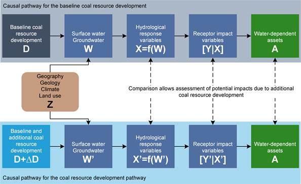
Two potential futures are considered in BAs:
- baseline coal resource development (baseline), a future that includes all coal mines and CSG fields that are commercially producing as of December 2012
- coal resource development pathway (CRDP), a future that includes all coal mines and CSG fields that are in the baseline as well as those that are expected to begin commercial production after December 2012.
The difference in results between CRDP and baseline is the change that is primarily reported in a BA. This change is due to the additional coal resource development – all coal mines and CSG fields, including expansions of baseline operations, that are expected to begin commercial production after December 2012.
Highlighting the potential impacts due to the additional coal resource development, and the comparison of these futures, is the fundamental focus of a BA, as illustrated in Figure 5, with the baseline in the top half of the figure and the CRDP in the bottom half of the figure. In BAs, changes in hydrological response variables and particular receptor impact variables are compared at receptors (points in the landscape where water-related impacts on assets are assessed).
Hydrological response variables are defined as the hydrological characteristics of the system that potentially change due to coal resource development (for example, drawdown or the annual streamflow volume). Receptor impact variables are the characteristics of the system that, according to the conceptual modelling, potentially change due to changes in hydrological response variables (for example, condition of the breeding habitat for a given species, or biomass of river red gums). Each landscape class and/or asset may be associated with one or more hydrological response variables and one or more particular receptor impact variables.
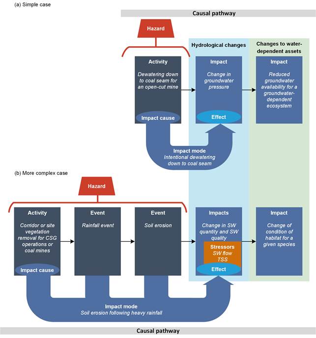
The italicised text is an example of a specified element in the Impact Modes and Effects Analysis. (a) In the simple case, an activity related to coal resource development directly causes a hydrological change which in turn causes an ecological change. The hazard is just the initial activity that directly leads to the effect (change in the quality and/or quantity of surface water or groundwater). (b) In the more complex case, an activity related to coal resource development initiates a chain of events. This chain of events, along with the stressor(s) (for example, surface water (SW) flow and total suspended solids (TSS)), causes a hydrological change which in turn causes an ecological change. The hazard is the initial activity plus the subsequent chain of events that lead to the effect.
The hazards arising from coal resource development are assessed using Impact Modes and Effects Analysis (IMEA). A hazard is an event, or chain of events, that might result in an effect (change in the quality and/or quantity of surface water or groundwater). In turn, an impact (consequence) is a change resulting from prior events, at any stage in a chain of events or a causal pathway (see more on causal pathways below). An impact might be equivalent to an effect, or it might be a change resulting from those effects (for example, ecological changes that result from hydrological changes).
Using IMEA, the hazards are firstly identified for all the activities (impact causes) and components in each of the five life-cycle stages. For CSG operations the stages are exploration and appraisal, construction, production, work-over and decommissioning. For coal mines the stages are exploration and appraisal, development, production, closure and rehabilitation. The hazards are scored on the following basis, defined specifically for the purposes of the IMEA:
- severity score: the magnitude of the impact resulting from a hazard, which is scored so that an increase (or decrease) in score indicates an increase (or decrease) in the magnitude of the impact
- likelihood score: the annual probability of a hazard occurring, which is scored so that a one-unit increase (or decrease) in score indicates a ten-fold increase (or decrease) in the probability of occurrence
- detection score: the expected time to discover a hazard, scored in such a way that a one-unit increase (or decrease) in score indicates a ten-fold increase (or decrease) in the expected time (measured in days) to discover it.
Impact modes and stressors are identified as they will help to define the causal pathways in Component 2: Model-data analysis. An impact mode is the manner in which a hazardous chain of events (initiated by an impact cause) could result in an effect (change in the quality and/or quantity of surface water or groundwater). There might be multiple impact modes for each activity or chain of events. A stressor is a chemical or biological agent, environmental condition or external stimulus that might contribute to an impact mode.
The hazard analysis reflects the conceptual models and beliefs that domain experts hold about the ways in which coal resource development might impact surface water and groundwater, and the relative importance of these potential impacts. As a result, the analysis enables these beliefs and conceptual models to be made transparent.
