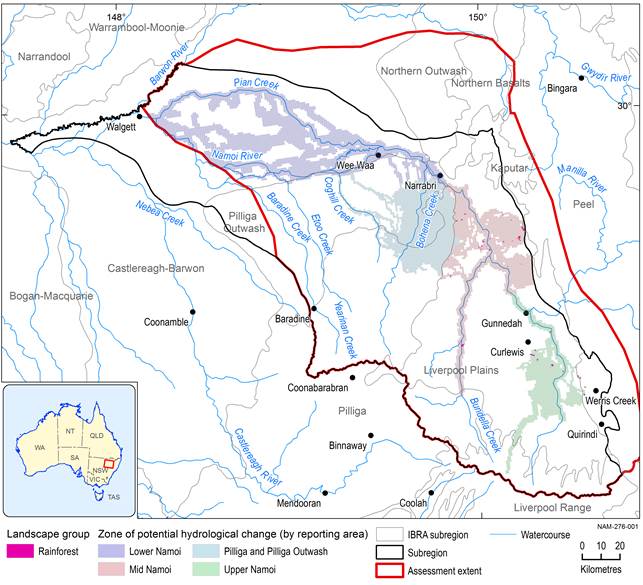
The ‘Rainforest’ landscape group is distinguished primarily by its vegetation structure and composition. Rainforests were identified based on Keith’s vegetation classification system, where ‘vegetation formation’ is the top level of the hierarchy, and included the ‘Rainforest’ and ‘Wet sclerophyll’ vegetation formations (Keith, 2004) (see Section 2.3.3 of companion product 2.3 for the Namoi subregion (Herr et al., 2018) for details on the landscape classification methodology). The ‘Wet sclerophyll’ vegetation formation makes up less than 0.3 km2 of the Namoi assessment extent, whereas most of the ‘Rainforest’ landscape group comprises the ‘Rainforest’ vegetation formation, making up approximately 200 km2 of the Namoi assessment extent (Table 43). A very small proportion of the ‘Rainforest’ landscape group within the assessment extent is located within the zone of potential hydrological change. There is 4 km2 of the ‘Rainforest’ landscape class and 0.3 km2 of the ‘Rainforest GDE’ landscape class within the zone of potential hydrological change (Table 43).
Table 43 Rainforest landscape classes and their corresponding areas and percentage contribution within the Namoi assessment extent and zone of potential hydrological change
GDE = groundwater-dependent ecosystem
Data: Bioregional Assessment Programme (Dataset 1)
The ‘Rainforest’ vegetation formations of Keith are defined as forests with a closed canopy generally dominated by non-eucalypt species with soft, horizontal leaves, however, various eucalypt species may be present as emergents (Keith, 2004). The ‘Rainforest’ landscape group in bioregional assessments (BAs) is predominately ‘Dry Rainforest’ or ‘Western Vine Thickets’ (both threatened vegetation classes in NSW). A detailed typology of these dry rainforest communities in north-western NSW indicates two distinct floristic groups within the Namoi assessment extent (Curran et al., 2008). The detailed study of Curran et al. (2008) showed that rainforest situated in the Peel, Kaputar and Northern Basalts Interim Biogeographic Regionalisation for Australia (IBRA) regions is predominantly notophyll vine thicket dominated by Ficus rubiginosa and Notelaea microcarpa. Here, the ‘Rainforest’ and ‘Rainforest GDE’ landscape classes tend to occupy higher elevations on scree slopes and gullies in Mt Kaputar National Park and other similar mountainous terrain (Figure 31; Curran et al., 2008; Benson et al., 2010).
IBRA = Interim Biogeographic Regionalisation for Australia
Data: Bioregional Assessment Programme (Dataset 1)
Further west on the Liverpool Plains, the ‘Rainforest’ landscape group is predominantly semi‑evergreen thicket (dominated by Notelaea microcarpa, Geijera parviflora and Ehretia membranifolia) and low microphyll vine forest (dominated by Cadellia pentastylis) according to the typology proposed by Curran et al. (2008). These pockets of rainforest are found on basalt outcrops and sandstone hills across the Liverpool Plains and Northern Outwash.
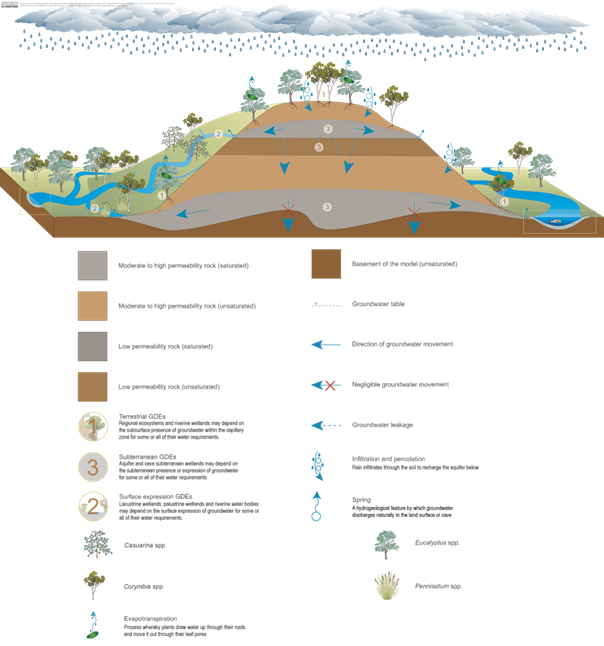
The water dependency of the ‘Rainforest’ landscape group is likely to be mostly from localised surface runoff, and in the case of the ‘Rainforest GDE’ landscape class, from groundwater sourced from localised discharge from fractured or porous substrates. The localised flow paths of water through basalt outcrops is captured in the pictorial conceptual model in Figure 32. Further evidence of these rainforest communities’ reliance on predominantly soil water derived from incident rain or fluctuating supply of subsurface water comes from studies by Curran et al. (2010). They showed large declines in tree water status across many different dry rainforest communities during drought (Curran et al., 2010). This would suggest limited or no access to the watertable and a heavy reliance on rainfall supply.
These systems are typical of those landscapes that form on basaltic (volcanic) rocks in the east of the Namoi subregion.
Source: DEHP (2015)
