This section describes the causal pathways that are relevant to the Namoi subregion for both coal mines and CSG operations (Table 14). These causal pathways describe the potential for impact of coal resource developments on water resources and water-dependent assets in the Namoi subregion. This does not mean, however, that these causal pathways are realised for each coal resource development. Many conditions need to be satisfied in order to assess impacts and these will be addressed in more detail through further work in surface water and groundwater modelling (companion product 2.6.1 (Aryal et al., 2018a) and companion product 2.6.2 for the Namoi subregion (Janardhanan et al., 2018), respectively) and assessment of knowledge gaps related to geological, groundwater and surface water connections between depth at coal resource exploitation and the surface (represented as landscape classes in the BA; see Section 2.3.3).
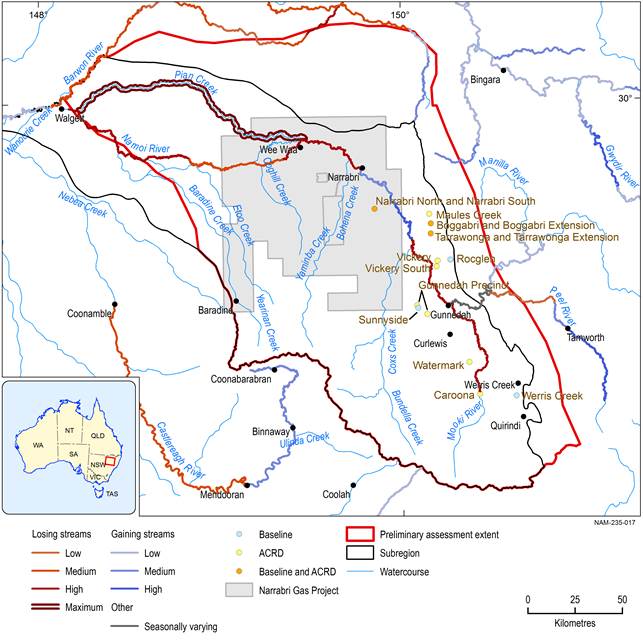
The coal resource development activities occur in the eastern and central parts of the subregion (Figure 39) within the Liverpool Plains, Pilliga and Pilliga Outwash geographic zones (see Table 5, Section 2.3.3). These activities are discussed in detail subsequently. This section firstly describes the four causal pathway groups that are relevant for the Namoi subregion more generally. Then it explains the coal resource development specific causal pathways for the subregion (Section 2.3.5.3.6). Finally, it provides a summary of the causal pathways for the subregion (Section 2.3.5.3.7).

There are three developments that are both baseline mines and additional coal resource developments (ACRD) on this map: Boggabri, Tarrawonga and Narrabri North are the baseline mines. Boggabri expansion, Tarrawonga expansion and Narrabri South are the additional coal resource developments. The coal resource developments in the coal resource development pathway (CRDP) are the sum of those in the baseline coal resource development (baseline) and the additional coal resource development.
The Narrabri Gas Project extent includes the exploration lease area.
Data: NSW Trade and Investment (Dataset 1), Bioregional Assessment Programme (Dataset 6, Dataset 7)
2.3.5.3.1 ‘Subsurface depressurisation and dewatering’ causal pathway group
Groundwater extraction associated with coal mines or CSG operations leads to depressurisation of the target coal seam and potentially any connected aquifer layers. Hydrological effects resulting from this causal pathway group depend on the local environment of the individual well (groundwater supply bore or CSG well) or open-cut or underground coal mines. The head changes caused by depressurisation of a coal seam may be passed to other strata, depending on the inherent hydraulic properties of the targeted seams as well as those of the adjacent and nearby rock strata. These affect the magnitude of head change, the spatial extent of head change and the time it takes for maximum head change to occur. There is no general rule for how depressurisation of the target aquifer will affect depressurisation of the target coal seam. In areas where a fault or fracture does exist, pressure changes may transmit more readily. However, this depends on whether the structures act as barriers or conduits to flow. Furthermore, it may be possible that prolonged depressurisation will reactivate a fault causal pathway, and thus create a connection that was not active prior to the aquifer depressurisation. Although conceptual modelling is able to identify that a change in groundwater pressure is possible, only field-verified fault locations and hydrological conductivity data with hydrological modelling will provide an opportunity to accurately quantify the extent of such a change.
Open-cut and underground coal mines must be dewatered to allow the safe extraction of coal, and this decrease in local groundwater level creates a gradient towards the drained coal seam, and induces flow into it. For open-cut coal mines, the primary sources of this water are the geological layers in which the mine is situated, down to the base of the pit. The spatial extent of the influence area of the pit dewatering is a function of the depth of mining, the local hydraulic properties of conductivity and storativity, and the time elapsed. For example, a particular asset may be so distant from an open-cut coal mine that, within the life of the mine, drawdown will not affect it. However, in the years following mine closure, the spread of the drawdown area may expose it to change. Quantification of this is only possible through predictive numerical groundwater modelling and targeted monitoring. It also requires the iterative incorporation of the monitoring information into the numerical modelling to improve precision of the model predictions. Mine pit dewatering may also affect alluvial aquifers, which in turn may affect the volume and timing of groundwater that is discharged as baseflow to connected watercourses. If the dewatering of an open-cut coal mine allows a drawdown cone to intersect with an alluvial aquifer supporting a stream, then some of the water that would naturally discharge to the stream is instead drawn away from the alluvium towards the open-cut coal mine.
Open-cut and underground coal mines require groundwater bores for monitoring, dewatering and water supply. They also have the potential to enhance connection between aquifers where well integrity is compromised. Connections from the surface to the target coal seam can also occur through ventilation and access shafts, although during the extraction phase, maintenance of these ventilation and access shafts aims to avoid a breach of their seals. In addition, underground mining may lead to subsidence at the land surface, with changes to the physical structure and properties of rocks and sediments occurring between the target coal seams and some distance up to, and including, the land surface. Where land subsidence coincides with a natural stream or river, water may be lost from the stream temporarily or permanently. Subsidence is discussed further in Section 2.3.5.3.3 (‘Surface water drainage’ causal pathway group).
Aquifer depressurisation associated with CSG operations and dewatering associated with coal mine development may affect target and non-target aquifers, at both local and regionally relevant scales, potentially leading to a hydrological effect in connected aquifers and both surface water and groundwater systems. Companion product 2.6.2 for the Namoi subregion (Janardhanan et al., 2018) describes the cumulative effects of aquifer depressurisation and dewatering. Companion product 2.6.1 for the Namoi subregion (Aryal et al., 2018a) details analogous hydrological changes to the surface water arising from the same coal resource developments.
Figure 40 summarises the causal pathway group ‘Subsurface depressurisation and dewatering’ associated with groundwater extraction and reduction in groundwater pressure in the surrounding and deeper aquifers. This can reduce the groundwater level if there is a connection to the surface aquifer and in turn results in groundwater property changes and may cause subsidence. ‘Change in groundwater flow’ is a summary term incorporating changes to the magnitude, direction and rate of groundwater flow. The disposal of the extracted groundwater is discussed in the ‘Operational water management and disposal’ pathway group (Section 2.3.5.3.4).
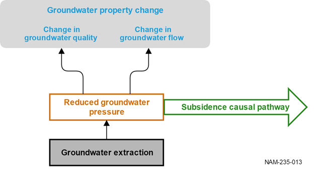
Groundwater extraction can cause changes to groundwater properties and also links to subsidence. Where there are connections of groundwater to surface water, there is a causal linkage between groundwater property changes and surface water property changes (see Figure 42). Subsidence is presented in Figure 44.
The colours in the diagram represent the following: white box with green writing = causal pathway, grey box with blue writing = hydrological effect, white box with orange writing = an event that forms part of the causal pathway chain, grey box with black writing = an activity.
2.3.5.3.2 ‘Subsurface physical flow paths’ causal pathway group
Preferential flow paths can be introduced between strata by hydraulic fracturing (including deviated drilling and changes to non-target aquifers) and compromised well integrity (including incomplete and/or compromised cementing or casing, miss perforation of target aquifers), and can impact on surface water – groundwater interactions (including changes to aquifer interconnectivity, mine expansion too close to a river or lake, preferential drainage and recharge associated with post-closure water filling the pit).
Potential effects are likely to be localised, but will continue until remedial actions are taken. Potential effects include the release of gas from the coal seams to the overlying geological layers and ultimately to the atmosphere. Inter-aquifer mixing can potentially compromise aquifer water quality. Effects on surface water systems are thought to be minimal and limited to reaches of surface water that receive baseflow from the groundwater system.
Hydraulic fracturing is designed to alter connectivity within target layers but may potentially alter inter-aquifer connectivity and introduce preferential flow paths. Hydraulic fracturing involves high-pressure injection of water (and other materials including chemical compounds and sand) to induce changes in coal seam properties to aid the release and flow of gas from the coal seams towards the well (Department of the Environment, 2014). The intended impact of changing aquifer properties is expected to be limited to the coal seams with a smaller risk of impacting neighbouring aquifers or aquitards. The lateral extent to which aquifer properties are changed is dependent on the physical properties of the coal, and diminishes with distance from the well. It is therefore also influenced by the number of wells and their spatial layout where this process is implemented. The water quality of the fractured coal seams and neighbouring aquifers can be compromised. While hydraulic fracturing is subject to management controls and monitoring, and Santos currently has no plans to use hydraulic fracturing as part of the Narrabri Gas Project (Santos, 2014), some of the chemicals in the compounds used for hydraulic fracturing or mobilised from the coal seam may seriously impair groundwater quality and could be difficult to decontaminate. At the end of hydraulic fracturing, water is pumped out, which is discussed as part of the ‘Subsurface depressurisation and dewatering’ causal pathway group (see Section 2.3.5.3.1 and also Figure 40). Potential effects of disposal of co-produced water removed after hydraulic fracturing are discussed as part of the ‘Operational water management’ causal pathway group (see Section 2.3.5.3.4).
Well construction may lead to enhanced connection between aquifer layers (Stuckey and Mulvey, 2013). It allows the mixing of waters from previously disconnected layers of different quality and chemical properties or of any fluid introduced down the well. CSG wells are drilled vertically from the surface to the coal seam and can be drilled within the coal seam by directional or deviated drilling. Maintaining well integrity throughout construction, operation and decommissioning phases is crucial to ensuring sustainable gas production and avoiding adverse environmental impacts. Incomplete and/or compromised casing and seals could introduce preferential flow paths. Miss perforation of the target aquifer can create a connection between previously disconnected aquifers. Preferential flow paths have the potential to connect any two or more consecutive or non-consecutive geological layers up to the land surface.
Open-cut coal mines can have a localised effect on preferential flow paths in surrounding aquifers and affect surface water – groundwater interactions. This includes changes to hydraulic gradients in the alluvial aquifer and connected aquifers associated with mine pit dewatering and preferential drainage and recharge associated with water filling any pit that remains below the watertable post-closure and rehabilitation. An important component of streamflow is baseflow, where groundwater discharges to the stream from the adjacent aquifer. Changes to hydraulic gradients can change the timing and volume of baseflow contributions to streams, which can affect the stream ecosystem within and downstream of tenements.
Void collapse as a result of underground mining can alter the hydraulic properties of overlying rock layers and may lead to subsidence at the surface. Subsidence is discussed as part of the ‘Surface water drainage’ causal pathway group below.
Figure 41 shows the major gaining and losing streams in the Namoi subregion that groundwater discharge changes are likely to influence. In losing streams, groundwater is not contributing to baseflow, whereas in gaining streams baseflow benefits from groundwater. All coal mines between the Coxs Creek – Namoi confluence and Narrabri have the potential to affect baseflow in the Namoi River and its tributaries in their sphere of hydraulic gradient change. However, this does not mean that a decrease in hydraulic gradient has no influence on other streams outside this area. The gaining and losing stream calculations are based on flow averages, and a stream can be a gaining stream at some stage of the hydrograph. The findings in companion product 2.1-2.2 for the Namoi region (Aryal et al., 2018b) support this in that hydraulic connection between the river and the alluvium shows changes in flux directions that respond to natural and human factors.
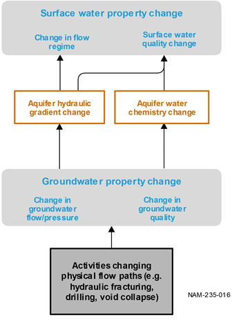
For smaller streams, which are gaining during some of the time, the reduction in the surrounding hydraulic gradient could result in an increase in low-flow or cease-to-flow times. As a consequence, responses by streams to changes in hydraulic gradient from mining are also likely in other areas of the subregion. Figure 42 shows a schematic of the causal relationship between groundwater property changes associated with the ‘Subsurface physical flow paths’ causal pathway group and surface water property changes.
The surface water and groundwater modelling reported in companion product 2.6.1 (Aryal et al., 2018a) and companion product 2.6.2 for the Namoi subregion (Janardhanan et al., 2018) will further provide the numeric information and spatial context of hydrological changes associated with coal resource developments in the baseline and CRDP.
There are three developments that are both baseline mines and additional coal resource developments (ACRD) on this map: Boggabri, Tarrawonga and Narrabri North are the baseline mines. Boggabri expansion, Tarrawonga expansion and Narrabri South are the additional coal resource developments. The coal resource developments in the coal resource development pathway (CRDP) are the sum of those in the baseline coal resource development (baseline) and the additional coal resource development.
The Narrabri Gas Project extent includes the exploration lease area.
Data: NSW Trade and Investment (Dataset 1), CSIRO (Dataset 5)
The colours in the diagram represent the following: grey box with blue writing = hydrological effect, white box with orange writing = an event that forms part of the causal pathway chain.
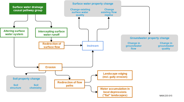
2.3.5.3.3 ‘Surface water drainage’ causal pathway group
Disruption of the surface drainage network may lead to a loss, or redirection, of runoff that can have long-term cumulative effects on downstream watercourses. The physical infrastructure of CSG operations and surface infrastructure of open-cut and underground coal mines, including land clearing, land levelling, the construction of roads and railway tracks, and pipelines and plant facilities for collection and transport of gas, can all disrupt natural surface water flows and pathways by redirecting and concentrating surface water runoff flows (Figure 43). Changes in flow regime and catastrophic events can alter flows and pathways either temporarily before returning to the previous state, or semi-permanently until the next event. This may lead to erosion of the land surface, stream banks or streambeds, and alter water quality in streams if new material is mobilised and washed into them. Geomorphological changes may create chemical or flow barriers to migration of aquatic organisms that can affect upstream watercourses (Figure 44). The interstitial spaces in the streambed – the hyporheic zone that connects surface water and groundwater – are ecologically important refuges for organisms and primary production (for a review see Boulton et al. (2010)). This section conceptually includes these spaces when discussing surface water related causal pathways.
Open-cut coal mines may also alter the surface water flows and pathways, through diverting site drain lines and on-site water retention. Intercepting runoff or streamflow into a mine area will remove a volume of water from the larger surface water drainage system. Both the quantity and quality of water downstream may be affected; quality may improve if the runoff or flow was naturally saline or highly turbid, or decrease if the inflow was fresher than the main stream. Surface water that is diverted around a mining operation may lead to concentration of surface flows that may alter water quality due to increased erosion and turbidity.
Although the total amount of runoff in a surface water catchment might be reduced by only a few percent, creek line diversions change where water enters the stream network. For example, a mine may alter runoff and drainage such that a single upland stream that contributes only a few percent of overall catchment streamflow is diverted around the mine to a watercourse further downstream. This has implications for the local stream environment and downstream reaches where the contribution at this point may be more significant. It can lead to flow being more concentrated, so that erosion risk is greater, or reduce the flow contributions to a water-dependent asset. The relative effect will be greater the closer an open-cut coal mine is to the stream. On-site water retention minimises the chances of any runoff from the mining operations or infrastructure being contaminated and released to the surface water catchment or watercourse. Therefore, any runoff that is naturally generated within the mining operations area is not available to streamflow and the environment. After mining ceases and if mine-site rehabilitation occurs, at some stage following this activity, some proportion of the rehabilitated land area will again become connected to the wider surface water catchment.
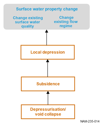
Subsidence is a lowering of the land surface due to collapse of the regolith and rock strata above an underground mine. It occurs when underground voids or cavities collapse, or when soil or geological formations (including coal seams, sandstone and other sedimentary strata) compact due to reduction in moisture content and pressure within the ground (Holla and Barclay, 2000; IESC, 2014). Subsidence occurs in two phases: active and residual. The active phase comprises about 90% of total subsidence and follows the advance of the mining front, occurring almost immediately with roof collapse. The residual phase takes more time, and occurs as the rocks compress and adjust in the collapsed zone above the mining void. The maximum vertical surface subsidence associated with underground coal mining is typically 1 to 2 m, but can be 2 to 3 m for a thick coal seam at shallow depth (Commonwealth of Australia, 2014b).The maximum subsidence predicted for the Stage 2 Narrabri underground coal mine is 2.17 m and 2.44 m
Depressurisation associated with CSG development also has the potential to compact the coal seam, which may result in subsidence of the land surface (IESC, 2014). There is currently very limited evidence of subsidence available for Australian CSG developments, however modelled predictions of coal seam subsidence for CSG fields in Queensland are up to 300 mm but would not be expected to result in subsidence at the ground surface (Commonwealth of Australia, 2014a).
The collapsed zone is highly fractured and commonly has enhanced hydraulic conductivity and storage to a thickness of about five times the thickness of extracted seam, although cracking and some increased hydraulic conductivity can occur over a thickness of 20 to 30 times the extracted seam height, depending on the strength of overlying strata (Waddington and Kay, 2002). At the surface, longwall mining creates long, closed rectangular basins that may extend beyond the physical boundaries of the mined area. Depending on depression depth, orientation, gradient of depression and connectivity to drainage lines, these depressions will retain more runoff than pre-disturbance and can be associated with local waterlogging. Extraction plans, prepared as part of the development consent process for longwall mines in NSW, must identify water resources at risk from the proposed mining and detail how mining will be undertaken to minimise impacts. In the Namoi subregion, subsidence from future coal mine development has the potential to only occur from the Narrabri South development, as the Caroona coal mine development is unlikely to proceed because of the NSW Government exploration licence buyback in 2016.
Subsidence may lead to a change in surface flow, enhanced erosion of the land surface and stream channels and in some instances loss of surface water through drainage into underground cavities. Figure 45 describes the impacts of subsidence caused by the removal of a coal seam in underground mining and, to a lesser extent, by depressurisation of an aquifer in the ‘Surface water drainage’ causal pathway group and the ‘Subsurface depressurisation and dewatering’ causal pathway group (Figure 43). NSW’s Environmental Planning and Assessment Act 1979 regulates underground mine subsidence via extraction plans (formerly subsidence management plans) that describe how a mine operator will manage and minimise subsidence impacts. Since mining consent in NSW is contingent on minimising the negative impacts of subsidence, as specified through an approved extraction plan, for BA modelling purposes the reduction in surface runoff from areas above longwall mines is assumed to be negligible. Details are reported in companion product 2.6.1 for the Namoi subregion (Aryal et al., 2018a).
The cumulative effects on natural surface drainage in the subregion may have medium- to long-term cumulative effects on watercourses within, upstream of and downstream of tenements.
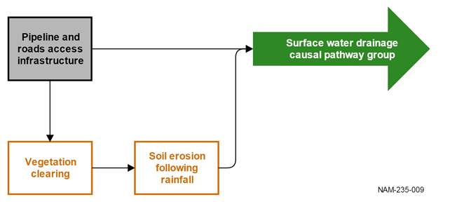
The colours in the diagram represent the following: green box with white writing = causal pathway group, white box with orange writing = an event that forms part of the causal pathway chain, grey box with black writing = an activity.
Groundwater properties can be influenced where there are interactions between surface water and groundwater (see Figure 42).
The colours in the diagram represent the following: green box with white writing = causal pathway group, white box with green writing = causal pathway, grey box with blue writing = hydrological effect, white box with orange writing = an event that forms part of the causal pathway chain, white box with blue writing = the specific environment where an event takes place.
The colours in the diagram represent the following: grey box with blue writing = hydrological effect, white box with orange writing = an event that forms part of the causal pathway chain.
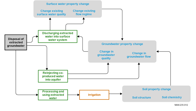
2.3.5.3.4 ‘Operational water management’ causal pathway group
CSG operations remove water from the coal seam to release gas during the production stage. If the produced water is of poor quality, it may require dilution with fresh water or treatment to remove salts, gas and other contaminants sourced from the coal seam.
Beneficial uses include water for site management such as dust suppression or washing, discharge to rivers for conveyance to beneficial uses, and reinjection to depleted aquifers. Co-produced water that is treated and disposed of locally via irrigation or release to rivers can affect water quality and quantity. Discharge of treated co-produced water to rivers and for irrigation can affect watertable levels and soil salt mobilisation along watercourses and near irrigation areas. Instream disposal leads to changes in surface water. Reinjection causes groundwater property changes and treatment or amendment of the groundwater for irrigation purposes, which may result in soil property changes (Figure 46).
Discharge of co-produced water from CSG operations for the Narrabri Gas Project is estimated to peak at 8 ML/day in the early stages of production, and is forecast to stabilise at around 4 ML/day on average approximately 10 years after production commences (Santos, 2012). Current options for disposal of co-produced water include use on site for dust suppression and operational requirements and the potential for irrigation or release as environmental flows of (reverse osmosis) treated water.
Water from open-cut and underground coal mines in the Namoi subregion is mostly used for operational purposes including dust suppression and coal processing. Discharge to rivers is limited to times of high flow and/or when water is a suitable quality. More detailed information on mine water management for each baseline mine and additional coal resource development in the Namoi is discussed in Section 2.1.6 in companion product 2.1-2.2 for the Namoi subregion (Aryal et al., 2018b).
Water management structures (dams, levee bunds and diversions) associated with open-cut coal mines can change natural surface drainage or cause excessive runoff during closure that has a cumulative effect on surface water and groundwater systems in the subregion. Upstream impacts that change watercourse geomorphology or create barriers to the migration of aquatic organisms are also possible.
Water management structures are likely to have medium- to long-term effects on surface water quality, direction and flow. Activities that involve discharge to rivers are likely to have episodic- to short-term effects on surface water flow and quality in watercourses in the aquifers in the subregion.
The effects are akin to the disposal of extracted groundwater (Figure 44), albeit being dependent on the water chemistry, temperature and discharge amount of the water source. One major effect of continual discharge is the increase in (base) flow, which can result in major shifts to the aquatic and riparian ecosystem as the stream is buffered against climatic low-flow or cease-to-flow events, however continual discharge is not currently allowed for mines in the Namoi subregion.
Changes to groundwater level and quality and surface water quality associated with discharge to rivers and irrigation that raises the watertable and mobilises salt are likely to be episodic to short term and localised. Other effects, including local reduction in species numbers, are likely to be in the medium to long term and include watercourses with aquifer connectivity that are within, upstream of and downstream of tenements.
The state regulations (as listed in Table 13, Section 2.3.4) and approval conditions for the individual mines regulate water take and discharges of water in the Namoi river basin. Monitoring groundwater and surface water quality – such as for heavy metals or BTEX (benzene, toluene, ethylbenzene and xylene), and the removal or disposal of these – is the responsibility of individual mining companies under their mine water management agreements. Any release of contaminated water to the surface water system, for example by leakage or overflow from a storage dam, will negatively affect downstream water quality. Mines will have monitoring strategies in-place as part of their approval conditions to monitor for any overflow or leaks from on-site storage dams.
The colours in the diagram represent the following: white box with green writing = causal pathway, grey box with blue writing = hydrological effect, white box with orange writing = an event that forms part of the causal pathway chain, grey box with black writing = an activity.
2.3.5.3.5 Summary of causal pathways
The four causal pathway groups are intrinsically connected through the activities that result in changes to groundwater and surface water. These changes are coal resource development activity specific in the case of pipeline and roads access infrastructure, redirection of surface flow, and groundwater extraction and disposal or the changes are a combination of a range of activities that lead to establishing preferential flow paths transcending stratigraphic units. The previous sections provided the details of the individual causal pathways, and in doing so had to trade off readability with showing all causal pathways and their connectivity. Figure 47 provides this overview of the causal pathway connectivity.
Future coal resource development activities (identified as grey boxes with black writing in Figure 47) and the mechanisms in which these changes affect surface water and the groundwater in the alluvium at the regional level are the main concern of a BA. In this section, the Assessment team outlined the conceptual understanding of these mechanisms – termed causal pathways – and including their linkages. There is one central causal pathway group, ‘Subsurface physical flow path’. It embeds these surface water and groundwater property changes, which are the result of linkages (identified through arrows in Figure 47) with all the other causal pathways.
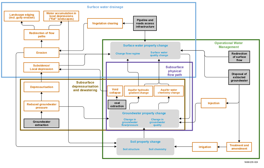
Figure 47 Causal pathway connectivity
The colours in the diagram represent the following: grey box with blue writing = hydrological effect, white box with orange writing = an event that forms part of the causal pathway chain, grey box with black writing = an activity.
2.3.5.3.6 Causal pathways for the coal resource development pathway
This section explains the coal resource development specific causal pathways for the Namoi subregion, which were developed in the ‘Conceptual modelling of causal pathways’ workshop (held in Canberra in August 2015) and links these to the generic causal pathway groups described in the previous sections.
Coal seam gas operations
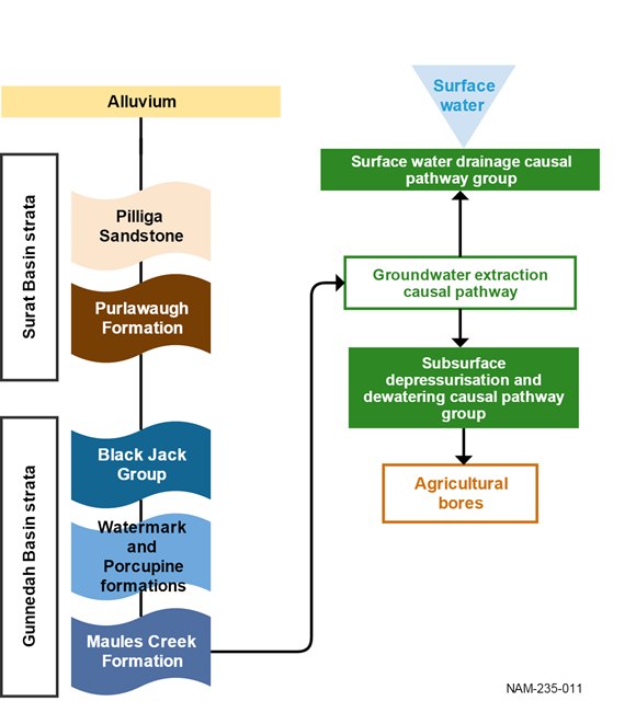
The Narrabri Gas Project is the only CSG development in the CRDP for the Namoi subregion. The Narrabri Gas Project is targeting the main coal seams in the lower Permian Maules Creek Formation. There is the potential for connectivity between the target coal seams and the surface and near-surface aquifers through the stratigraphic units outlined in Figure 48, which leads to causal pathways that are related to subsidence and groundwater extraction (‘Subsurface depressurisation and dewatering’ and ‘Subsurface physical flow paths’ causal pathway groups, respectively). Detailed descriptions of the causal pathways are in Section 2.3.5.3.1 and Section 2.3.5.3.2 and they relate specifically to the causal pathways outlined in Figure 40 and Figure 44. Agricultural bores accessing the alluvial aquifers and the Pilliga Sandstone aquifer in the Great Artesian Basin (GAB) may have reduced flow if the induced pressure change from CSG depressurisation propagates vertically through the overlying sequence, potentially leading to a drop in water levels and bores drying up. This may also result in any of the GAB bores that are artesian ceasing to flow naturally, requiring pumping to extract water. Propagation of the depressurisation cone may be impeded or enhanced by faults and the presence or absence of aquitards.
Causal pathways are discussed in Section 2.3.5.3 (see Figure 40, Figure 42, Figure 43, Figure 44, Figure 45 and Figure 46).
Open-cut and underground coal mines
There are 15 open-cut and underground coal mines in the CRDP for the Namoi subregion. For the purposes of assessing potential causal pathways, the coal mines in the CRDP for the Namoi subregion have been grouped according to the target coal seams and the geology. The mines in the CRDP located in the Mullaley sub-basin (Narrabri North Mine, Narrabri South, Watermark Coal Project, Caroona Coal Project, Sunnyside Mine and Gunnedah Precinct) primarily target the Hoskissons Coal in the upper Permian Black Jack Group. These mines are overlain by Surat Basin strata (with thickness on average about 300 m) and alluvium. The remaining mines: Maules Creek Mine, Boggabri Coal Mine, Tarrawonga Mine, Vickery Coal Project and Rocglen Mine are located in the Maules Creek sub-basin and target coal seams in the Maules Creek Formation. Only Gunnedah Basin strata and alluvial sediments are present at these mine sites, as the Surat Basin strata have been completely removed by uplift and erosion.
There is the potential for connectivity between the target coal seams and the surface and near-surface aquifers through the Gunnedah Basin strata, which can lead to hydrological changes related to subsidence and groundwater extraction. Detailed descriptions of the causal pathways are in Section 2.3.5.3.1 (‘Subsurface depressurisation and dewatering’ causal pathway group) and Section 2.3.5.3.2 (‘Subsurface physical flow paths’ causal pathway group) and they relate specifically to the causal pathways outlined in Figure 40 and Figure 44.
Coal mines in the Mullaley sub-basin
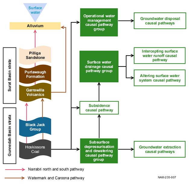
The coal resource developments in the Mullaley sub-basin include the Narrabri North Mine, Narrabri South and the Caroona Coal Project (all underground mines), and the open-cut Watermark Coal Project, Sunnyside Mine and Gunnedah Precinct (see Figure 7, Figure 8 and Figure 9). These mines target the coal seams in the upper Permian Black Jack Group, primarily the Hoskissons Coal. The Narrabri North Mine and Narrabri South project area is partly overlain by the Pilliga Sandstone and Purlawaugh Formation (see pink line in Figure 49) of the Surat Basin. In the south of the Mullaley sub-basin around the Watermark and Caroona coal projects, only the Garrawilla Volcanics are present. Consequently, causal pathways for the Watermark Coal Project and Caroona Coal Project will not include the Pilliga Sandstone and Purlawaugh Formation.
Activities relevant to open-cut developments involve aquifer dewatering of the target seam, which will potentially reduce water pressures in the coal seams and lower the regional watertable, with some potential for transmission of these water level reductions to other aquifers (depending on hydraulic parameters and thickness of aquitards etc.). Activities relevant to the three underground coal mines involve the extraction of coal from underground longwall panels which results in the collapse of strata above the mined-out panels, leading to subsidence. There is the potential to impact surface physical flow paths. The mine infrastructure interferes with and disrupts the natural surface drainage. Management, storage and disposal of mine water may also create localised impacts. Figure 49 provides a schematic of the causal pathways through the stratigraphic layers.
Causal pathways are discussed in Section 2.3.5.3 (see Figure 40, Figure 42, Figure 43, Figure 44, Figure 45 and Figure 46).
Coal mines in the Maules Creek sub-basin
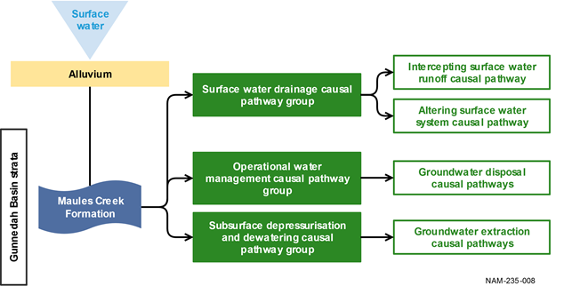
The Maules Creek Mine, Boggabri (including expansion) Coal Mine, Tarrawonga (including expansion) Mine, Vickery Coal Project (including Vickery South) and Rocglen Mine are located in the Maules Creek sub-basin to the east of the Boggabri Ridge (see Figure 8 and Figure 9) and are targeting the coal seams in the Maules Creek Formation. There are no Surat Basin units in this part of the Namoi subregion, nor are there any units from the Black Jack Group due to erosion of Gunnedah Basin strata above the Maules Creek Formation in the Maules Creek sub-basin (Geological Survey of NSW, 2002) (see Figure 8). Consequently there is the potential for a lowering of the regional watertable in the Upper Namoi alluvium if mining activities occur close to the alluvium. Figure 50 provides a schematic of the causal pathway to impact through the stratigraphic layers. There is potential for interaction between the Namoi River alluvium and associated waters flowing into the Namoi River if mining results in a decrease in baseflow to the river, as this is an area of gaining streams (Figure 41).
Causal pathways are discussed in Section 2.3.5.3 (see Figure 40, Figure 42, Figure 43, Figure 44 and Figure 45).
Werris Creek Mine
The Werris Creek Mine is located in the Werrie Basin (see Section 2.3.2 for more detail). The target coal seams for the Werris Creek Mine are in the Willow Tree Formation (see Figure 6 in Section 2.3.2). The Werrie Basin is a structurally isolated (non-contiguous) part of the Gunnedah Basin. The very low permeability basement rocks of the New England Orogen underlying the Werrie Basin essentially form a natural hydrogeological barrier that isolates the regional groundwater flow system of the Werrie Basin from the Gunnedah Basin. Consequently, the Werris Creek Mine is not included in the Namoi groundwater modelling. The surface waters around the Werris Creek Mine flow into the Namoi River, and so form part of the surface water modelling. Figure 51 provides a schematic of the causal pathways through the stratigraphic layers in the Werrie Basin.
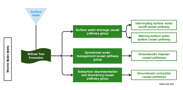
Figure 51 Schematic of causal pathways for the Werris Creek Mine in the Werrie Basin
2.3.5.3.7 Summary of the causal pathways for the coal resource development pathway
This section describes the potential cumulative effects of the CRDP in the Namoi subregion, which includes one additional CSG operation, four baseline open-cut coal mines, one baseline underground coal mine and nine additional open-cut coal mines or mine expansions and two additional underground coal mines (see Table 11 in Section 2.3.4). The cumulative hydrological effects of multiple coal resource developments in the Namoi subregion, which overlap in both time and space, have the potential to affect aquifers, catchments and watercourses via the four main causal pathway groups (Table 14).
The four causal pathway groups associated with the baseline coal mining operations, and the additional CSG and coal mining operations have the potential to directly affect the local and regional groundwater system, and the surface water – groundwater interactions in aquifer areas of the Namoi River and associated streams.
Based on Figure 18 in Section 2.3.3 and the locations of the additional coal resource development (Figure 39), the expected area of potential groundwater change is confined to the Liverpool Plains and the Pilliga and Pilliga Outwash. Surface water – groundwater interactions and potential surface water responses may occur in the streams of these geographic zones and those in the Castlereagh-Barwon geographic zones (as per Table 5 in Section 2.3.3).
Figure 52 shows the coal resource developments overlain with the landscape groups in the PAE. It shows that all landscape groups are potentially affected – namely, ‘Dryland remnant vegetation’, ‘Floodplain or lowland riverine’, ‘Non-floodplain or upland riverine’, ‘Human modified’, ‘Springs’ and ‘Rainforest’. While this assessment is helpful in identifying the broad spatial extent of the hydrological responses to coal resource development and the potentially impacted landscape groups in the subregion, it is only a starting point that enables a coarse identification of zones (as outlined in Figure 18), where impacts are very unlikely. A quantitative assessment of these hydrological changes will delineate the areas where impacts to ecosystems may potentially occur. Hydrological modelling outputs (detailed in companion product 2.6.1 for the Namoi subregion (Aryal et al., 2018a)) will provide the numeric values and the detailed spatial context of the hydrological responses to coal resource development in the Namoi subregion. A result of this modelling is the refinement of the expected zone of potential hydrological change, which will enable a more precise identification of landscape classes potentially impacted.
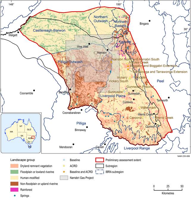
There are three developments that are both baseline mines and additional coal resource developments (ACRD) on this map: Boggabri, Tarrawonga and Narrabri North are the baseline mines. Boggabri expansion, Tarrawonga expansion and Narrabri South are the additional coal resource developments. The coal resource developments in the coal resource development pathway (CRDP) are the sum of those in the baseline coal resource development (baseline) and the additional coal resource development.
Mining developments are likely to impact Liverpool Plains, Pilliga and Pilliga Outwash. Although the coal seam gas (CSG) petroleum exploration lease covers the Castlereagh-Barwon, Northern Outwash, the Santos environmental impact statement indicates that CSG developments are unlikely to occur in these additional regions (Chubb, 2017).
The Narrabri Gas Project extent includes the exploration lease area.
Data: NSW Trade and Investment (Dataset 1), SEWPaC (Dataset 2), Bioregional Assessment Programme (Dataset 3, Dataset 6, Dataset 7)
Three mines in the baseline (Boggabri, Narrabri North and Tarrawonga) have expansions that are modelled in the CRDP. The baseline defines the effects of the mines on groundwater and surface water and is modelled into the future. Modelling the additional coal resource developments, which include coal mining and CSG, defines the future changes in water. All four causal pathways are relevant to these coal resource developments. The causal pathway groups are the same for both open-cut and underground coal mines and CSG operations in the CRDP (Table 17).
Table 17 Causal pathway groups arising from coal mines and coal seam gas operations for coal resource developments in the baseline and coal resource development pathway (CRDP)
