Summary
The development of a landscape classification was undertaken with the objective of enhancing our understanding of the potential water-related impacts across the subregion. This landscape classification characterises the diverse range of water-dependent assets into a smaller number of classes for further analysis. It is based on key landscape properties related to patterns in geology, geomorphology, hydrology and ecology, as well as the land use patterns associated with human-modified ecosystems. The process of devising and implementing a landscape classification for the preliminary assessment extent (PAE) of the Namoi subregion used existing data associated with surface water network, aquatic and/or groundwater-dependent ecosystems (GDEs), remnant vegetation and land use mapping. Where appropriate, the approach (outlined in this section) has built on and integrated existing classification systems implemented by state and federal government institutions. This section describes the attributes by which landscape features are categorised and their corresponding rule sets for spatial data, which are represented as polygons (e.g. wetlands), polylines (stream network) and points (e.g. springs).
A total of 29 landscape classes, comprising 6 landscape groups, were defined using the rule sets described here. Most of the PAE (59%) is classed under the ‘Human-modified’ landscape group that includes agricultural, urban and other intensive land uses. For the remaining parts of the landscape, most (24% of the PAE) fall into the ‘Dryland remnant vegetation’ landscape group, which is not considered to be water dependent. The ‘Floodplain or lowland riverine’ landscape group covers approximately 6% of the PAE and includes the lowland riverine systems and the adjacent landscape classes associated with the riparian and back plain environments. Approximately 10% of the PAE and almost 72% of the watercourses are included in the ‘Non-floodplain or upland riverine’ landscape group that included a large extent of vegetation classified as groundwater dependent. Aspects of water dependency and the vegetation communities associated with each landscape group are discussed.
The Namoi subregion exhibits environmental gradients in climate and physiognomy that support a variety of ecosystems. These ecosystems form regions of similarity that are described in the Interim Biogeographic Regionalisation for Australia (IBRA; SEWPaC, Dataset 1). These IBRA subregions (Figure 17) define four broad geographic zones relevant for the subsequent assessment of water-related impacts. The surface water flow through these geographic zones is increasing generally from east to west (see schematic in Figure 18). The zones are the Liverpool Plains, the elevated areas between the Nandewar Range and the Merriwa district (termed here the Merriwa-Nandewar uplands, which comprise the Peel, Northern Basalt, Northern Outwash and Kaputar subregions of the Nandewar bioregion), Pilliga, the Pilliga Outwash and the Castlereagh-Barwon. The physical characteristics within each zone are similar. These zones are apparent in the soils, land and soil capability, land cover and land use maps (see Figure 5, Figure 6, Figure 7 and Figure 8 in companion product 1.1 for the Namoi subregion (Welsh et al., 2014)). Their common characteristics are summarised in Table 5.
The above described regions provide a coarse conceptual understanding that is useful in defining and ruling out areas that do not intersect with the zones of potential hydrological change when combined with conceptual understanding developed in Section 2.3.5. However, the development of receptor impact models – that is, the integration of hydrological and ecosystem understanding to analyse the risk to impact on ecosystems – requires a more hydrologically focused understanding of the ecological landscape elements. IBRA regions were developed for the purpose of defining representative conservation reserve systems, so are not fit for the purpose of developing receptor impact models related to changes in water. For this purpose the subsequent part of this section develops a specific landscape classification, which is essential to an understanding of water-related impacts. This classification is designed to reduce the complexity in the receptor impact modelling and aid in the selection and development of appropriate conceptual models for the landscape classes (see companion product 1.3 for the Namoi subregion (O’Grady et al., 2015)).
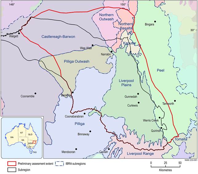
Data: SEWPaC (Dataset 1)
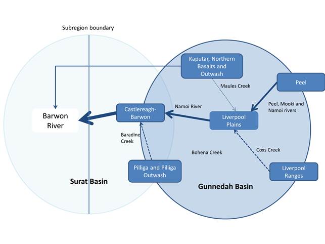
The flow direction is towards the western subregion boundary into the Barwon River. Dashed arrows represent ephemeral streams and full arrows permanent streams, and the increasing thickness of the lines indicates broadly increase in water volume.
Table 5 Characteristics of the four Interim Biogeographic Regionalisation for Australia (IBRA) subregions in the Namoi subregion
na = not applicable
Data: SEWPaC (Dataset 1), ABARES (Dataset 2), NSW OEH (Dataset 3)
