The hazard analysis for the Namoi subregion was based on the existing and proposed CSG operations and coal mines and their water management outlined in Section2.3.4.1 and Section 2.3.4.2, respectively. The analysis occurred during a one-day hazard workshop (held in May 2015) with experts from CSIRO, Geoscience Australia and the Department of the Environment and considered activities – planned events associated with a CSG operation or coal mine – of the different coal mining and CSG life-cycle stages. Specific coal resource expertise from these agencies beyond the Assessment team was included. Hazard analysis workshops for other subregions, some of which had stronger external representation, have assisted in confirming the comprehensiveness of the hazards identified for the Namoi subregion.
Participants of this Namoi hazard workshop identified and scored detailed hazards using the IMEA, aligned with the companion product M11 (as listed in Table 1) for hazard analysis (Ford et al., 2016). Further details are available in the hazard analysis dataset (Bioregional Assessment Programme, Dataset 4). The following sections provide a description of these identified hazards.
2.3.5.2.1 Hazard handling and scope
A long list of hazards has been generated for both coal mines and CSG operations with no particular consideration given to whether coal resource developments are part of the baseline or are additional coal resource developments. The hazards of primary focus from a BA perspective are those that extend beyond the coal resource development site and that may have cumulative impacts, as these are consistent with the regional focus of a BA, and are where BAs will add greatest value beyond site-specific environmental impact statements (EIS). Ultimately, however, BAs need to be able to address all identified hazards by considering the scope, modelling, other literature or narratives, and specifying where science gaps may exist.
BAs are constrained by considering only impacts that can happen via water, and so hazards such as dust, fire or noise are deemed out of scope and are addressed by site-based risk management unless there is a water-mediated pathway.
In general, leading practice is assumed and accidents are deemed to be covered adequately by site-based risk management procedures and are considered beyond the scope of BAs; for example, the failure of a pipeline is covered by site-based risk management. Hazards that pertain to the coal resource development site and with no off-site impacts are important to acknowledge but will typically be addressed by site-based risk management procedures.
The hazard analysis generated a list of all potential hazards for the different life-cycle stages of the coal resource developments. Life-cycle stages have different scale and duration, which is reflected in the scores for consequence and/or likelihood of the hazards associated with these activities. Hazards that are in scope are addressed in the BA modelling; where modelling is not possible, a qualitative assessment (narrative) is provided (see companion submethodology M11 (as listed in Table 1) for hazard analysis (Ford et al., 2016)).
The relationship between individual hazards and the hydrological effects (groundwater properties, surface water properties) falls into causal pathways, which are combined into pathway groups: ‘Subsurface depressurisation and dewatering’, ‘Subsurface physical flow paths’, ‘Surface water drainage’ and ‘Operational water management’. The associated hydrological effects for the quality, quantity and pressure of surface and groundwater are shown in Table 14. More details on the causal pathways are available in companion submethodology M05 (as listed in Table 1) for developing a coal resource development pathway (Henderson et al., 2016). Section 2.3.5.3 provides further details on these causal pathway groups with focus on the Namoi subregion.
Table 14 Causal pathway groups and associated hydrological effects for the Namoi subregion
Subsurface water refers to the water in interstitial spaces below surface water expressions.
2.3.5.2.2 Coal seam gas operations
The components for CSG operations that are in scope are CSG wells, roads and infrastructure, and CSG processing. All hazard priority numbers overlap in their range associated with their respective modelling or narrative category, so no priority hazards were selected. Instead, all hazards were addressed.
There are 166 CSG hazards associated with CSG operations in the Namoi subregion. These hazards were grouped into hazard groups which link though individual causal pathways (as outlined in companion submethodology M05 (as listed in Table 1) for developing a conceptual model of causal pathways (Henderson et al., 2016)) to causal pathway groups (Table 15). Details of the hazards and their associated hazard groups, as well as their grouping according to the scope of assessment within the BA, are available in the hazard analysis for the Namoi subregion (Bioregional Assessment Programme, Dataset 4). Six hazards are addressed through groundwater quantity and surface water flow modelling and there is a wide overlap in the range of their hazard priority numbers (Figure 35). These fall under the hazard groups:
- ‘discharge of co-produced water to stream’
- ‘depressurisation of coal seam and non-target aquifers from water and gas extraction’.
Another 37 hazards are qualitatively assessed through narrative (Figure 36). These fall under the hazard groups:
- ‘unregulated or forced release of water due to dam/containment failure’
- ‘changes to water quality associated with depressurisation and connecting aquifers’
- ‘subsidence’
- ‘hydraulic fracturing and potential of contamination of aquifers’
- ‘disruption of surface drainage network’
- ‘bore and well construction’.
There are 123 hazards that are deemed out of scope for this BA because they are considered to be managed through site-based risk management; these hazards are not considered further in the BA. Details of these out-of-scope hazards are available from Dataset 4 (Bioregional Assessment Programme).
Table 15 Hazard groups for coal seam gas operations that are deemed in scope (addressed through modelling or narrative) and out of scope (site-based risk management) for the Namoi subregion
‘Modelling’ refers to hazards that are expected to be modelled in surface water and groundwater models. ‘Narrative’ refers to hazards that are not modelled but are important to provide comment on. ‘Site-based risk management’ refers to hazards that are believed important to be acknowledged but are handled by site-based risk management procedures.
For further information, see companion submethodology M11 (as listed in Table 1) for hazard analysis (Ford et al., 2016).
Typography and punctuation are consistent with the hazard analysis dataset (Bioregional Assessment Programme, Dataset 4).
Data: Bioregional Assessment Programme (Dataset 4)
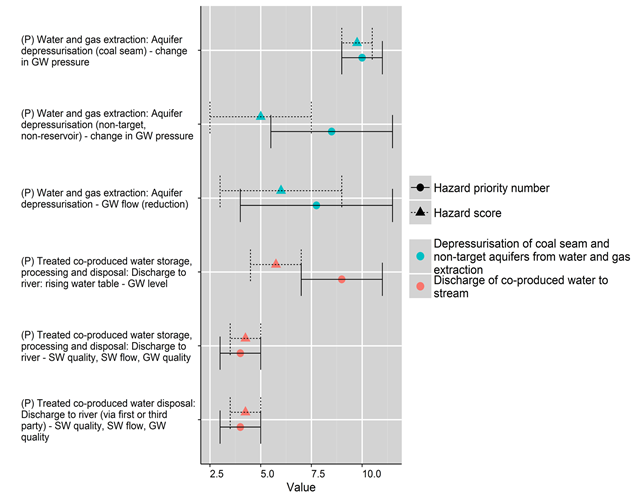
The x-axis shows the hazard priority number and hazard score for potential hazards as scored by experts. The same hazard may appear multiple times, as it may arise from a number of different life-cycle stages and activities. Hazards and their associated hydrology effects are listed with the syntax (Life-cycle stage) [Activity]: [Impact mode] – Effects, where life-cycle stage is (P) –production.
GW = groundwater, SW = surface water
Data: Bioregional Assessment Programme (Dataset 4)
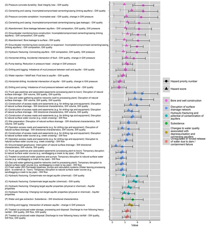
The x-axis shows the hazard priority number and hazard score for potential hazards. The same hazard may appear multiple times, as it may arise from a number of different life-cycle stages and activities. Hazards and associated hydrological effects are listed with the syntax (Life-cycle stage) [Activity]: [Impact mode] – Effects, where life-cycle stages are indicated by (C) – closure, (D) –development, (E) – exploration and appraisal, or (P) – production.
GW = groundwater, SW = surface water, TDS = total dissolved solids, TSS = total suspended solids
Data: Bioregional Assessment Programme (Dataset 4)
2.3.5.2.3 Open-cut and underground coal mines
All hazard priority numbers for in-scope hazards overlap in their range associated with their respective modelling or narrative category, so no priority hazards were selected. Instead, all hazards are addressed. Underground coal mining is distinctly different from open-cut mining and more akin to CSG in terms of water impact at depth. Surface facilities and infrastructure are similar for both underground and open-cut coal mines. There are 239 coal mine hazards in the Namoi subregion that are related to underground and open-cut mining, and associated infrastructure and surface facilities. Details of the hazard analysis are available from the hazard analysis for the Namoi subregion (Bioregional Assessment Programme, Dataset 4). The hazard groups for these hazards are listed in Table 16.
There are 24 hazards (Figure 37) that are in scope and addressed by the groundwater and surface water modelling. These hazards are related to:
- ‘post mining − creation of groundwater sink, artificial point of recharge’
- ‘disruption of natural surface drainage and change in run-off (interception of run-off by pit)’
- ‘groundwater dewatering of target seam (underground) and layers to coal seam (open-cut)’
- ‘subsidence due to underground mining’.
An additional seven hazards (Figure 38) are covered through narrative and these are related to:
- ‘disruption of natural surface drainage (beyond site, e.g. rail)’
- ‘unregulated or forced release of water due to dam/containment failure’
- ‘changes to water quality associated with depressurisation and connecting aquifers’.
There are 208 hazards that are out of scope as they were deemed to be adequately managed through site-based risk management. These hazards are not considered further in the BA. Details of these out-of-scope hazards are available from Dataset 4 (Bioregional Assessment Programme).
Table 16 Hazards for open-cut and underground coal mines that are deemed in scope (addressed through hydrological modelling or narrative) and out of scope (site-based risk management)
‘Modelling’ refers to hazards that are expected to be modelled in surface water and groundwater models. ‘Narrative’ refers to hazards that are not modelled but are important to provide comment on. ‘Site-based risk management’ refers to hazards that are believed important to be acknowledged but are handled by site-based risk management procedures.
For further information, see companion submethodology M11 (as listed in Table 1) for hazard analysis (Ford et al., 2016).
Typography and punctuation are consistent with the hazard analysis dataset (Bioregional Assessment Programme, Dataset 4).
Data: Bioregional Assessment Programme (Dataset 4)
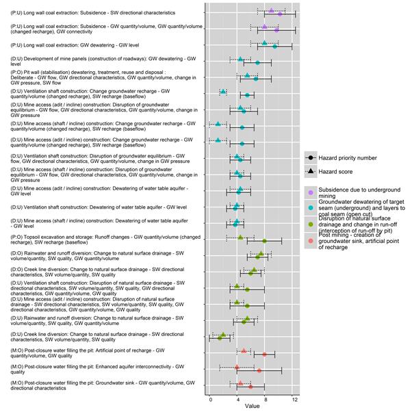
The x-axis shows the hazard priority number and hazard scores for potential hazards. The same hazard may appear multiple times, as it may arise from a number of different life-cycle stages and activities. Hazards and associated hydrological effects are listed with the syntax (Life-cycle stage) [Activity]: [Impact mode] – Effects, where life-cycle stages are indicated by (D) – development or (P) – production for open pit (O) and underground mining (U) components.
Typography and punctuation are consistent with the hazard analysis dataset (Bioregional Assessment Programme, Dataset 4).
GW = groundwater, SW = surface water, TDS = total dissolved solids, TSS = total suspended solids
Data: Bioregional Assessment Programme (Dataset 4)
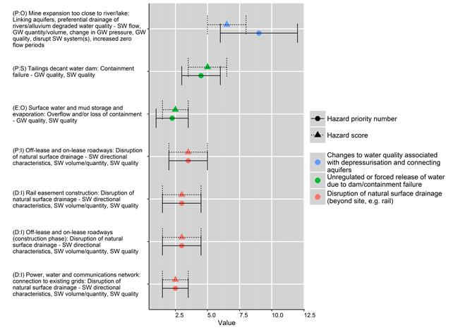
The x-axis shows the hazard priority number and hazard score for potential hazards. The same hazard may appear multiple times, as it may arise from a number of different life-cycle stages and activities. Hazards and associated hydrological effects are listed with the syntax [Life‑cycle stage][Activity]:[Impact mode] – Effects, where life-cycle stages are indicated by (D) – development, (P) – production or (E) – exploration for components open pit (O), infrastructure (I) or surface facility (S).
Typography and punctuation are consistent with the hazard analysis dataset (Bioregional Assessment Programme, Dataset 4).
GW = groundwater, SW = surface water, TDS = total dissolved solids, TSS = total suspended solids
Data: Bioregional Assessment Programme (Dataset 4)
