Although there is a long history of exploration for coal-related resources in the Galilee subregion, it is considered to be a greenfields development area as there is no history of commercial coal or CSG production. Hence there are no coal resource developments in the baseline for the Galilee subregion – a future that includes all coal mines and coal seam gas (CSG) fields that are commercially producing as of December 2012. The causal pathways introduced in Table 13 and Table 14 are described in further detail and relate to the CRDP – a future that includes all coal mines and coal seam gas (CSG) fields that are in the baseline as well as those that are expected to begin commercial production after December 2012. Hydrological changes due to any of the causal pathways described in the following sections will contribute to differences that may occur between the CRDP and the baseline (See Section 2.3.1.1 and Section 2.3.5.3.3).
2.3.5.3.1 Coal seam gas operations
Hazards associated with CSG operations that are considered to be in scope for the Assessment are aggregated into four primary causal pathway groups (refer to companion submethodology M05 (as listed in Table 1) for developing a conceptual model of causal pathways (Henderson et al., 2016)). These four causal pathway groups represent a conceptual model of the chain of events that begins with an activity and ends with a potential impact on a groundwater- or surface water-dependent asset.
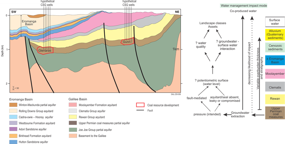
In this section, the four causal pathway groups associated with CSG activities are described to provide subregion-specific context and show how different components of the hydrological system may be affected by potential CSG activities. The causal pathways are explained using a cross-section based on the three-dimensional geological model (presented in Section 2.3.2) through the area of potential CSG development.
As noted in Section 2.3.5.2.1, CSG projects in the Galilee subregion are not as advanced in their development nor permitting as many of the coal mine developments. The most advanced CSG project in the Galilee subregion is the Glenaras Project (refer to companion product 1.2 for the Galilee subregion (Lewis et al., 2014)). As of December 2015, Galilee Energy Limited had refined the CSG well design for the Glenaras pilot wellfield and were utilising the updated well design to conduct an extended pump test to assess CSG flow rates to surface (Galilee Energy Ltd, 2015; Lansom, 2015).
Depending on results, the next steps could include applications to regulatory authorities for the necessary permits required for the Glenaras Project to proceed towards a production phase. It is possible that the potential for cumulative impacts from CSG may only become significant once multiple developments are commercially producing.
2.3.5.3.1.1 ‘Subsurface depressurisation and dewatering’ causal pathway group
The suite of causal pathways in the ‘Subsurface depressurisation and dewatering’ causal pathway group is outlined in companion submethodology M05 (as listed in Table 1) for developing a conceptual model of causal pathways (Henderson et al., 2016). Relevant causal pathways in this causal pathway group for CSG operations in the Galilee subregion are ‘Groundwater pumping enabling coal seam gas extraction’ and ‘Unplanned groundwater changes in non-target aquifers’. In most cases, the confining hydrostatic pressure of groundwater within coal seams is a significant controlling factor on gas migration. Thus for CSG to be produced to the surface there is commonly a need to decrease groundwater pressures in the coal seams. Coal seams do not need to be completely dewatered in order for CSG to flow; groundwater pressures only need to be decreased below a critical pressure so that CSG can flow to the surface. This critical pressure (the desorption pressure) is a factor that is unique to each project and one of the many parameters that must be determined prior to a CSG project proceeding towards commercial operations.
In the Galilee subregion, the primary target seams for CSG development are in the upper Permian coal measures (Figure 32). If present, the Aramac Coal Meaures, which are situated stratigraphically below the upper Permian coal measures, can be a secondary target.
Coal seams will need to be depressurised in order for CSG to flow to the surface. Factors that can affect the extent to which depressurisation occurs and propagates around CSG projects include:
- local geological architecture (e.g. lithological variation, geological structures such as faults and fold hinges)
- configuration and characteristics of groundwater flow systems (e.g. aquifers, aquitards, flow direction)
- hydraulic properties, connectivity of aquifer systems and CSG reservoirs
- rate and duration of pumping (extent of depressurisation is time dependent)
- desorption pressure and depth of coal seams
- overburden thickness.
Due to the various complexities mentioned above, the degree of depressurisation that can occur at depth in a coal seam will not occur near the surface. Depressurisation in coal seams will propagate laterally through the coal measures at a certain rate and usually to a lesser extent, vertically through the overlying geological sequence. Propagation of the depressurisation cone may be impeded or enhanced by faults (fault mediated), the presence or absence of aquitard sequences such as the Rewan Group, or the distribution of lower permeability shaley sequences within the coal measures. Shaley units that could impede propagation of depressurisation both vertically and laterally are recognised in the upper Permian coal measures (Lansom, 2015), as are regional aquitards such as the Rewan Group and Moolayember Formation (Figure 32).
If an aquitard is thin or absent, then this may enhance propagation of a depressurisation cone laterally or vertically. The Rewan Group does vary in thickness and thins and pinches out towards the western margin of the Galilee Basin (Figure 32). Along the western margin of the Galilee subregion, some parts of the upper Permian coal measures can be in direct contact with overlying aquifers such as the Hutton Sandstone (Section 2.3.2.2.2). If propagation of a depressurisation cone were to extend this far west, then there is potential for impact on groundwater pressures in overlying aquifers. If pressures decreased along the western margins of the upper Permian coal measures to such a point where groundwater flow reversal may potentially occur (i.e. groundwater were to flow from Hutton Sandstone into the upper Permian coal measures), then this may potentially result in changes to groundwater pressures in the Hutton Sandstone aquifer.
Causal pathways in this group that are relevant for coal seam gas in the Galilee subregion are ‘Groundwater pumping enabling coal seam gas extraction’ and ‘Unplanned groundwater changes in non-target aquifers’. Refer to Table 13 for further details.
Cross-section is a stylised equivalent of Figure 6 in Section 2.3.2.
Arrows in diagram highlight direction of potential causal pathways.
Question marks next to text in figure suggest that change may or may not occur. It depends on site-specific circumstances.
2.3.5.3.1.2 ‘Subsurface physical flow paths’ causal pathway group
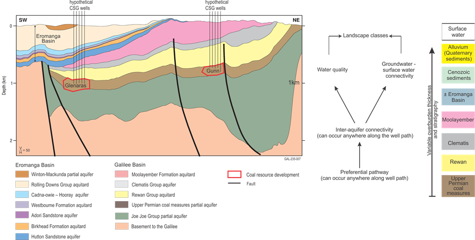
The companion submethodology M05 (as listed in Table 1) for developing a conceptual model of causal pathways (Henderson et al., 2016) outlines the suite of causal pathways in this group. According to the hazard analysis presented in Table 13, the causal pathways of specific interest to the Galilee subregion are ‘Failure of well integrity’ and ‘Hydraulic fracturing’ (Figure 33).
CSG well integrity is important because it prevents connectivity between aquifers and reservoirs via the path of the well. Wells are drilled during the exploration and appraisal phase to evaluate the potential commercial viability of the prospective CSG operations, and during the production phase to extract commercial quantities of identified gas. Maintaining well integrity throughout construction, operation and decommissioning phases is crucial to ensuring sustainable gas production and avoiding adverse environmental impacts. Throughout these stages of the CSG life cycle, preserving well integrity prevents the inter-aquifer mixing of fluids (liquid or gas) and pressures, as well as preventing the escape of fluids to the surface. Incomplete and/or compromised casing and seals could introduce preferential pathways for groundwater flow between aquifers. Well design and control measures include the selection of the right grade of casing and cement that are suitable for well conditions, as well as the proper installation of well casing and proper completion of cementing operations.
The impacts associated with compromised well integrity are more likely to be of a local scale; that is, they are likely to be restricted to within the vicinity of the compromised well. These impacts, however, will continue until remedial action is taken. These impacts include the escape of gas from the coal seams to the overlying geological layers and potentially to the atmosphere. In addition, inter-aquifer mixing could potentially locally compromise the water quality of some aquifers such as the Hutton Sandstone. Adverse impacts on surface water systems are thought to be minimal due to the limited spatial scale of the impact.
Causal pathways in this group that are relevant for coal seam gas operations in the Galilee subregion are: ‘Failure of well integrity’ and ‘Hydraulic fracturing’. Refer to Table 13 for further details.
Cross-section is a stylised equivalent of Figure 6 in Section 2.3.2.
Arrows in diagram highlight direction of potential causal pathways.
Hydraulic fracturing is one of a suite of reservoir stimulation techniques that can be used to enhance gas flow from a CSG reservoir to a well. Due to the CSG fields being at a relatively early phase of development, it is uncertain whether hydraulic fracturing will become a technique that is readily applied across the Galilee Basin. For the Glenaras pilot wellfield, the drilling of horizontal CSG wells along target coal seams is considered to be a more applicable technology for increasing gas flow to CSG wells rather than hydraulic fracturing (Galilee Energy Ltd, 2016; Lansom, 2016). It is unknown whether this will be the case for other CSG projects in the Galilee subregion.
2.3.5.3.1.3 ‘Surface water drainage’ causal pathway group
The companion submethodology M05 (as listed in Table 1) for developing a conceptual model of causal pathways (Henderson et al., 2016) outlines the suite of causal pathways included in this causal pathway group. According to the hazard analysis presented in Table 13, the causal pathways of specific interest to the Galilee subregion include ‘Altering the surface water system’ and ‘Intercepting surface water runoff’.
Disruption of the surface drainage network may lead to a loss or redirection of runoff, which can have long-term cumulative effects on downstream watercourses. Some of steps in the development of physical infrastructure for CSG operations may include land clearing, land levelling, the construction of hard-packed areas such as roads and tracks, pipelines and plant for collection and transport of gas, can all disrupt natural surface flows and pathways by redirecting and concentrating flows. Water flow and landscape topography co-evolve in natural systems such that the areas of most concentrated flow tend to be the most resistant to erosion. Changes in flow regime and catastrophic events can alter flows and pathways either temporarily before returning to the previous state, or semi-permanently until the next event. In the same way, anthropogenic structures and earth works associated with CSG exploration and production may divert and concentrate surface flow. This may lead to erosion of the land surface, stream banks or streambeds, and alter water quality in streams if new material is mobilised and washed into them.
The CSG projects outlined in Section 2.3.4 are located west of the Great Dividing Range, in the Cooper Creek – Bulloo river basin (see Figure 17 in Section 2.3.2.2). In particular, the Thomson river basin is a major river basin situated in the headwaters of the Cooper Creek–Bulloo river basin.
As part of the Bioregional Assessment Programme, Wakelin-King (2015) presented an overview of the fluvial geomorphology of the Thomson river basin and, in particular, focused on river reaches that lie within the Galilee subregion. Some of the findings of Wakelin-King (2015) are:
- Landforms in the upland areas of the Thomson river basin, despite relatively high riverbed gradients, relate to low-energy fluvial processes. The stability of the fluvial landforms are likely to relate to low discharge flow regimes
- Geomorphology of the upper parts of the Thomson river basin is significantly different to what is found downstream. Therefore, conclusions drawn from studies in better understood areas of the Cooper Creek – Bulloo river basin (e.g. Cooper Creek) may not be applicable to the upper reaches of the Thomson river basin.
Wakelin-King (2015) suggested that more detailed fluvial geomorphological studies be undertaken if there are industry development proposals that have the potential to alter the streamflow regime.
2.3.5.3.1.4 ‘Operational water management’ causal pathway group
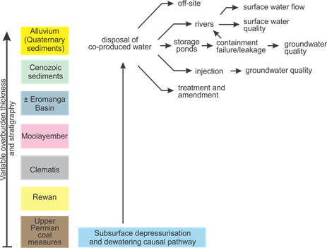
CSG operations require water during different stages of the life cycle (e.g. for the construction of exploration and appraisal wells and for the construction of development wells). However, water is also produced during the production stage and needs to be effectively and appropriately managed (Figure 34). The water needed for CSG activities could be sourced from either surface water or groundwater systems. If direct extraction from surface water features such as rivers were to occur, this could result in some impact to their flow regime depending on the volume of extraction relative to streamflow. Extraction from surface water streamflow would only be possible if permits allow and, in the Galilee subregion, it occurs during wetter months of the year when streams are flowing.
Co-produced water from groundwater pumping, as mentioned in Table 13, may be disposed of via various methods. These may include:
- storage tanks or ponds. This is currently the case for Glenaras Project (Lewis et al., 2014)
- reinjection (managed aquifer recharge) to a groundwater system. This may have potential impacts on groundwater quality for aquifers that would need to be addressed as part of any management plan. It may also have a positive impact on groundwater pressures in an aquifer
- reuse for other purposes such as for agricultural purposes after adequate treatment and amendment. Water quality should be such that it does not have any adverse impacts on soil properties and the water resource
- discharge of treated water to surface water systems. This may result in potential impacts to flow regime, fluvial geomorphology (Wakelin-King, 2015) or water quality. Impacts could be positive or negative
- reuse in a project as part of CSG development or production activities. This would be dependent on water quality.
Hazards relating directly to the ‘Operational water management’ causal pathway group are not included in the top 30 hazards as outlined in Table 13. This may, in part, reflect the current stages that CSG projects are at in the Galilee subregion. More detail is required on which treatment options would be applicable for water disposal in the Galilee subregion. Any water treatment and disposal options would be subject to regulatory oversight and approval by Queensland state agencies. The findings of Wakelin-King (2015) may be pertinent, depending on the pathway taken for treatment of co-produced water.
Arrows in diagram highlight potential causal pathways.
2.3.5.3.2 Open-cut and underground coal mines
As outlined in Section 2.3.1 and Section 2.3.4, 7 of the 14 coal mine developments in the CRDP have sufficient data and information available for them to be quantitatively assessed through groundwater and surface water modelling. Cumulative hydrological changes resulting from the groundwater and surface water modelling for these seven coal mine developments will be reported in companion product 2.6.1 and (Karim et al., 2018) and companion product 2.6.2 (Peeters et al., 2018) for the Galilee subregion.
In this section, the four causal pathway groups associated with coal mine activities (Table 14) are described to provide subregion-specific context and show how different components of the hydrological system may be affected by coal mine activities. The companion submethodology M05 (as listed in Table 1) for developing a conceptual model of causal pathways (Henderson et al., 2016) provides detail on various causal pathway groups utilised in BAs.
2.3.5.3.2.1 ‘Subsurface depressurisation and dewatering’ causal pathway group
Relevant causal pathways in this group for coal mine developments in the Galilee subregion include ‘groundwater pumping enabling open-cut mining’ and ‘groundwater pumping enabling underground mining’. Dewatering of aquifers is required if mining is to occur below the level of the watertable, as mine working areas have to be relatively dry for safety and operational reasons. This results in development of a drawdown cone (depressurisation) around the mine areas, resulting in localised redirection of groundwater flow towards mine areas.
The method for dewatering may vary with the mining method (e.g. open pit or underground). Open-cut mine areas need to be dewatered down to a depth that is below the floor of the pit and, to a certain extent, away from the pit walls to ensure that groundwater pressures do not cause stability issues for the pit or excessive inflow into the pit. Underground mine areas also need to be dry and dewatered. Groundwater in rock surrounding underground workings can be either completely or partly dewatered. Again this depends on operational requirements and the local hydrogeological regime.
Regardless of the mine type, overall there will be a resultant drop in groundwater levels and pressures around mine areas as all proposed coal mine developments in the Galilee subregion will extend deeper than the watertable. The extent to which drawdown propagates around mine areas can be dependent on:
- local geological architecture and its complexity (e.g. lithological variation, structures)
- configuration of groundwater flow systems (e.g. aquifers, aquitards, flow direction)
- hydraulic properties and connectivity of aquifer systems
- rate and duration of pumping (extent of drawdown is also time dependent)
- mine depth and mining method
- overburden thickness above underground mine workings.
Due to these various complexities, depressurisation at depth in the coal measures does not necessarily equate to the same magnitude of drawdown impact in the watertable aquifer near the surface.
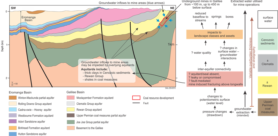
A drawdown cone will develop around each coal mine development as all proposed developments in the CRDP will mine coal to well below the existing watertable level. If the drawdown cones that are generated around each mine by pumping overlap (which is probable given there are mining operations that are adjacent to each other), then the amount of drawdown in the areas of overlap become cumulative in nature. To impact near the surface, drawdown has to propagate through any rocks that overlie the coal seam that is being mined (the overburden). Whether drawdown propagates to the surface through the overburden is dependent on factors listed previously. Across the Galilee subregion, there is considerable variation in thickness of overburden to the top of the upper Permian coal measures varies (Figure 9, Section 2.3.2.2.1.1; Figure 35, Figure 36). Just west of coal mine development areas, overburden thickens considerably to greater than 300 m.
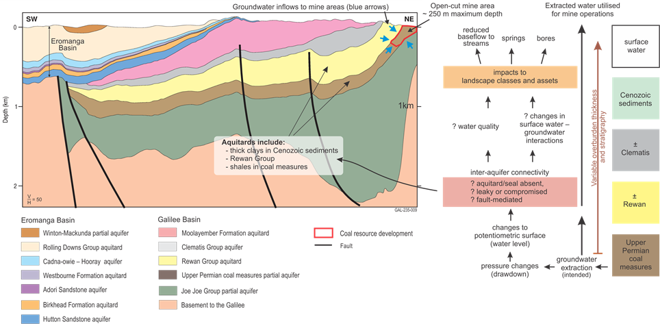
Figure 35 outlines the causal pathway of how dewatering and/or depressurisation may propagate around and away from an open-cut mine area. The far right-hand side of Figure 35 outlines the near mine stratigraphy, which can include upper Permian coal measures, Rewan Group, Clematis Group and Cenozoic sediments. Aquitards in a mine sequence may include clay layers in Cenozoic sediments (not shown in Figure 35), shales in upper Permian coal measures and Rewan Group.
The causal pathway linkage is that pumping around a mine development will draw down groundwater levels/pressures around the mine areas and increase the potential for groundwater to flow towards the mine area. Mine areas become a local groundwater sink due to development of groundwater pressures that are locally lower than what is in the surrounding aquifers.
Depending on the local geological configuration, groundwater flows may be impeded by aquitards in the stratigraphic sequence or enhanced if there are nearby aquifers such as porous sandstones. Structures such as faults, if present, may either impede flow (a flow barrier, if for instance clay filled) or act as conduit (Bense et al., 2013). As groundwater drawdown propagates towards the surface and laterally, it may encounter other aquifers, (e.g the Clematis Group Aquifer) or if near-the surface groundwater flow systems in unconfined Cenozoic aquifers. The potential impact of groundater drawdown in this instance would be to reduce pressures in the regional confined aquifer, which may affect bore yields or nearby springs, or to lower the watertable in an unconfined aquifer. Lowering the watertable may decrease water availability to groundwater-dependent ecosystems, riparian environments and deep-rooted tree species (e.g. river red gum (Eucalyptus camaldulensis)); induce changes to baseflow to river systems; or even change a gaining stream to a losing stream. Changes to baseflow may result in local changes to river flow regime such as decreased river flow and duration of flow during low-flow periods. As outlined in Section 2.3.2.3, most rivers in the Galilee subregion in any given year can have many months of no flow. This may make these river systems more vulnerable if the baseflow component is altered with increases in the durations of low-flow and or zero-flow periods.
Figure 36 outlines the causal pathway for how dewatering and/or depressurisation may propagate around and away from an underground mine. Differences between open-cut and underground dewatering include:
- Groundwater is not necessarily completely dewatered above all underground workings.
- Fracturing above longwall areas may enhance groundwater inflows into mine areas or provide increased connectivity between aquifers or to the surface.
The groundwater systems are not necessarily dewatered above the underground mine workings. However, some degree of depressurisation will occur around the underground mine workings. This depressurisation could be impeded vertically by aquitards in the sequence. Deeper mine workings may also have the potential to increase the lateral extent of the effects of depressurisation and drawdown. Depressurisation associated with underground mine workings would be additive to a drawdown cone associated with dewatering around nearby open pits. As of February 2016, all proposed underground mines in the Galilee subregion are associated either directly or indirectly to open-cut mine operations.
The fractured zones that can form above the goaf of a longwall panel may enhance aquifer connectivity, thereby increasing inflows. Significant fracturing across an aquitard may increase inter-aquifer connectivity or potentially provide a pathway for recharge if fractures reach the surface. Section 2.3.5.3.2.2 provides more detail on causal pathways associated with fracturing and subsidence.
Cross-section is a stylised equivalent of Figure 6 in Section 2.3.2.
Black arrows in diagram highlight potential causal pathways.
Blue arrows in cross-section represent hypothetical groundwater flow induced through depressurisation around coal mine.
Question marks next to text suggest that change may or may not occur. It depends on site-specific circumstances.
Cross-section is a stylised equivalent of Figure 6 in Section 2.3.2.
Black arrows in diagram highlight potential causal pathways.
Blue arrows in cross-section represent hypothetical groundwater flow induced through depressurisation around coal mines.
Question marks next to text suggest that change may or may not occur. It depends on site-specific circumstances.
In the Galilee subregion, seven coal mine developments are included in the groundwater and surface water modelling for the CRDP. Groundwater modelling is a component of the BA for the Galilee subregion, the results of which will be reported in companion product 2.6.2 for the Galiliee subregion (Peeters et al., 2018). This modelling will determine if drawdown cones around the proposed coal mine developments will be cumulative and provide an estimate of the extent of hydrological change.
2.3.5.3.2.2 Fracturing and subsidence above underground mine longwall panels
All underground mining is proposed to occur in coal seams in the upper Permian coal measures. Fracturing and subsidence will occur to varying degrees above underground longwall mines once they commence operations in the Galilee subregion. The degree of fracturing and subsidence that occurs is dependent on a number of factors including:
- local geological architecture and complexity (e.g. lithological variation, stratigraphy, structures and other discontinuities such as bedding, bedding thickness)
- geotechnical parameters for coal seams and surrounding rock mass (e.g. rock strength, stiffness)
- overburden thickness, mined coal thickness
- longwall extent and configuration, single- or multi-seam longwall operations
- topography
- angle of draw around longwall areas, which is generally defined as the boundary of an area where subsidence at the surface is greater than 20 mm (Commonwealth of Australia, 2015). The angle of draw can be dependent on the interplay of factors mentioned in previous points.
For BAs, the fracturing component is included under the ‘Subsurface physical flow paths’ causal pathway group as the causal pathway ‘Subsurface fracturing above underground longwall panels’. However, the subsidence component included under the ‘Surface water drainage’ causal pathway group under the causal pathway ‘Subsidence of land surface’ as subsidence is likely to have the most impact on surface features (see companion submethodology M05 (as listed in Table 1) for developing a conceptual model of causal pathways (Henderson et al., 2016)). For the Assessment, fracturing and subsidence related causal pathways will be reported in this section as the two causal pathways (‘Subsurface fracturing above underground longwall panels’ and ‘Subsidence of land surface’) are primarily a result of the one coal mine related activity (underground longwall mining).
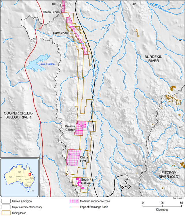
Generally, areas affected by subsidence and fracturing are greatest above or immediately adjacent to areas where longwall coal mining has taken place. Horizontal far field effects such as movement on faults or bedding planes can also occur (usually within 500 m of longwall areas; Commonwealth of Australia, 2015). On a more regional scale, the combined cumulative area of the various proposed underground mines may change the surface water regime in the Belyando river basin (Figure 37). The Belyando River is a significant tributary to the Burdekin River. Proposed areas where longwall mining, fracturing and subsidence may occur are shown in Figure 37.
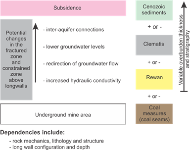
The major changes that can occur below ground level due to ‘Subsurface fracturing above underground longwall panels’ causal pathway are outlined in Figure 38. Changes may include increased aquifer connectivity due to preferential flow along fractures, or increased flow through an aquitard compromised by fracturing, increased conductivity and lower groundwater levels. Increases in hydraulic conductivity can have implications for dewatering and depressurisation around coal mines as it could result in increases to water production (Section 2.3.5.3.1.1).
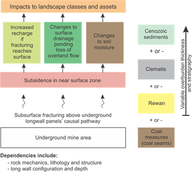
Figure 39 shows potential changes relating to ‘Subsidence of land surface’ causal pathway. Changes may include local changes in topography, ponding of water, increased erosion resulting in sedimentation and nutrient runoff, redirection of surface flows, some changes to surface water regime, and if fracturing reaches the surface there is potential for increased recharge to groundwater. However, the degree of change is strongly dependent on site-specific conditions.
Subsidence areas derived from relevant mine environmental impact statement.
Data: QDNRM (Dataset 2), Geoscience Australia (Dataset 3)
Arrows in diagram highlight potential causal pathways.
Figure 39 'Subsidence of land surface' causal pathway for the Galilee subregion
Arrows in diagram highlight potential causal pathways.
2.3.5.3.2.3 ‘Surface water drainage’ causal pathway group
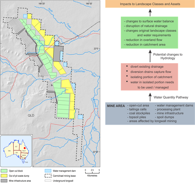
‘Altering surface water systems’ is the causal pathway in this group that is relevant for coal mine developments in the Galilee subregion. For operational reasons surface water drainage needs to be modified in order to control the amount of water at the mine site. It also lessens the potential for inadvertent releases of water from a mine site. Rainfall that falls on site is utilised on site. Some examples of the types of major infrastructure that are part of a typical coal mine site are shown in Figure 40.
Early in the development of a mine site, where the installation of diversion drains is required, bund walls and other measures will divert surface water flows, including overland flow, around the mine site to continue down slope of the mine development. This is done to minimise the amount of water required to be managed on site. This effectively isolates the mine area from the rest of the catchment and reduces the overall catchment area that can contribute to runoff. A reduction in catchment area may reduce surface water flows, which in turn may result in changes to some components of the water balance. Redirection of flow to other parts of the catchment may also increase surface water flows locally in areas where it previously did not occur. Whether these changes are significant or not will vary from site to site.
CRDP coal mines included in the groundwater and surface water modelling for the Galilee subregion (Section 2.3.4) are located in the Belyando river basin, which is part of the larger Burdekin river basin (see also Figure 17 in Section 2.3.2.2). Hence surface water modelling for the Assessment is focused on Burdekin river basin (companion product 2.6.1 for the Galilee subregion (Karim et al., 2018)).
Figure 40 'Altering surface water systems' causal pathway for the Galilee subregion
Data: Queensland Department of State Development, Infrastructure and Planning (Dataset 4)
2.3.5.3.3 Causal pathways for the coal resource development pathway
There were no commercially producing coal mines or CSG fields in the Galilee subregion as of December 2012, which (as outlined in Section 2.3.1.1) is the date used to define the baseline for BAs. This was still the case as of April 2016, as there were no coal mines or CSG fields in construction or producing commercially in the Galilee subregion.
The causal pathways listed in Table 14 and described in Section 2.3.5.3.2 relate only to the coal resource developments in the CRDP that were quantitatively assessed in the groundwater and surface water modelling. Hydrological changes due to any of the causal pathways would contribute to differences that may occur between the CRDP and the baseline (Section 2.3.1.1).

Product Finalisation date
- 2.3.1 Methods
- 2.3.2 Summary of key system components, processes and interactions
- 2.3.3 Ecosystems
- 2.3.4 Baseline and coal resource development pathway
- 2.3.5 Conceptual model of causal pathways
- Citation
- Acknowledgements
- Currency of scientific results
- Contributors to the Technical Programme
- About this technical product

