Hazard analysis is a critical part of the BA as it rigorously and systematically identifies the potential impacts (hazards) on water-dependent assets arising from whole-of-life-cycle CSG and coal mine activities. Only hazards identified through this process are considered further in a BA.
A hazard analysis conducted for the Galilee subregion (Bioregional Assessment Programme, Dataset 1) was based on the proposed CSG operations and coal mines (as outlined Section 2.3.4.1) and their water management (Section 2.3.4.2). The hazard analysis for the Galilee subregion was completed during a one-day workshop in March 2015 with experts from CSIRO, Geoscience Australia and the Department of the Environment.
2.3.5.2.1 Coal seam gas operations
The hazard analysis identified some 260 activities associated with CSG projects. However, not all of the activities listed were applicable to the Galilee subregion or had potential to impact water. Further information on hazards that are within scope for the Assessment is outlined in Section 2.3.5.2.3.
The hazard scores from the IMEA help to pinpoint what would potentially be the more serious hazards. The top 30 hazards and their associated activities and impact modes are outlined in Figure 30 and identify the following potential effects to aquifers including:
- hydrostatic depressurisation of the aquifer (target coal seam and non-target aquifers)
- fault-mediated depressurisation caused by faults opening or closing due to CSG operations
- aquitard-mediated depressurisation (i.e. an aquitard is absent or the integrity of the aquitard is compromised in some parts of the subregion)
- connection of previously disconnected aquifers by hydraulic fracturing, incomplete casing of wells or incomplete seal integrity
- disruption to natural surface drainage.
After impacts on aquifers, the potential impacts associated with storage, processing and disposal of treated water were all identified as potentially important in this context.
Although a number of hazards have been identified, hazards for CSG operations were not included in groundwater and surface water modelling undertaken for the CRDP (Section 2.3.4.1) as the potential for development of CSG projects to full production in the Galilee subregion may be still be some years into the future.
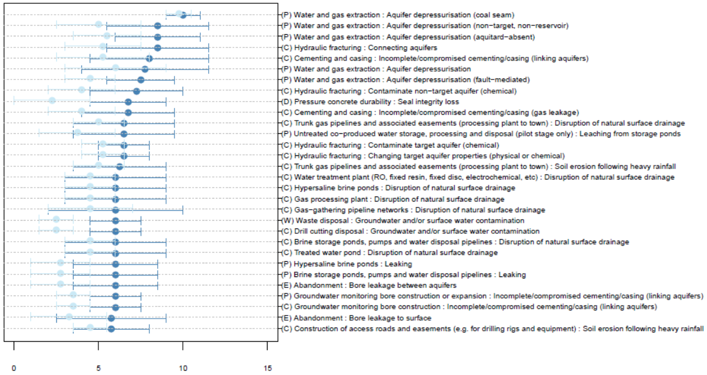
The x-axis shows the hazard priority number and hazard score for potential hazards. The intervals between the highest and lowest hazard priority number are shown in dark blue; the intervals for hazard score are shown in light blue. The same hazard may appear multiple times, as it may arise from a number of different life-cycle stages and activities. Hazards are listed with the syntax [Life‑cycle stage][Activity]:[Impact mode], where life-cycle stages are indicated by (E) for exploration and appraisal, (C) for construction, (P) for production and (D) for decommissioning.
Typology and punctuation are consistent with Dataset 1.
Data: Bioregional Assessment Programme (Dataset 1)
2.3.5.2.2 Open-cut and underground coal mines
The hazard analysis identified some 274 activities associated with open-cut and underground mines. However, not all of the activities listed were applicable to the Galilee subregion or had potential to impact water. Further information on hazards that are within scope for the Assessment is outlined in Section 2.3.5.2.3.
The hazard priority number scores from IMEA help to pinpoint what would potentially be the more serious hazards. The top 30 hazards and their associated activities and impact modes are outlined in Figure 31. Issues associated with underground longwall mining such as fracturing and subsidence and disruption to surface drainage were some of the highest ranked hazards.
The potential impacts of leaching is associated with 8 of the 30 highest ranked hazards, including leaching from:
- in-pit waste rock dumps and backfill
- waste rock dumps outside of the pit
- coal stockpiles (in and out of the pit)
- run-of-mine (ROM) plants
- tailings decant water dams.
Leaching ranks fairly high due to difficulties in detecting whether leaching of mine or coal-related materials is taking place and if leachate changed quality of the nearby groundwater.
The following are identified as having the potential to link, or cause leakage between, aquifers:
- incomplete or compromised cementing of groundwater supply and monitoring bores
- mine expansion too close to a water body
- abandoned exploration and appraisal bores.
These – together with dewatering and enhanced aquifer interconnectivity caused by post-closure water filling the open-cut and underground mine workings – are identified as potentially important hazards. The remaining 30 highest ranked hazards include:
- soil erosion caused by heavy rainfall or failure to successfully rehabilitate abandoned mines
- artificial groundwater recharge (following pit abandonment).
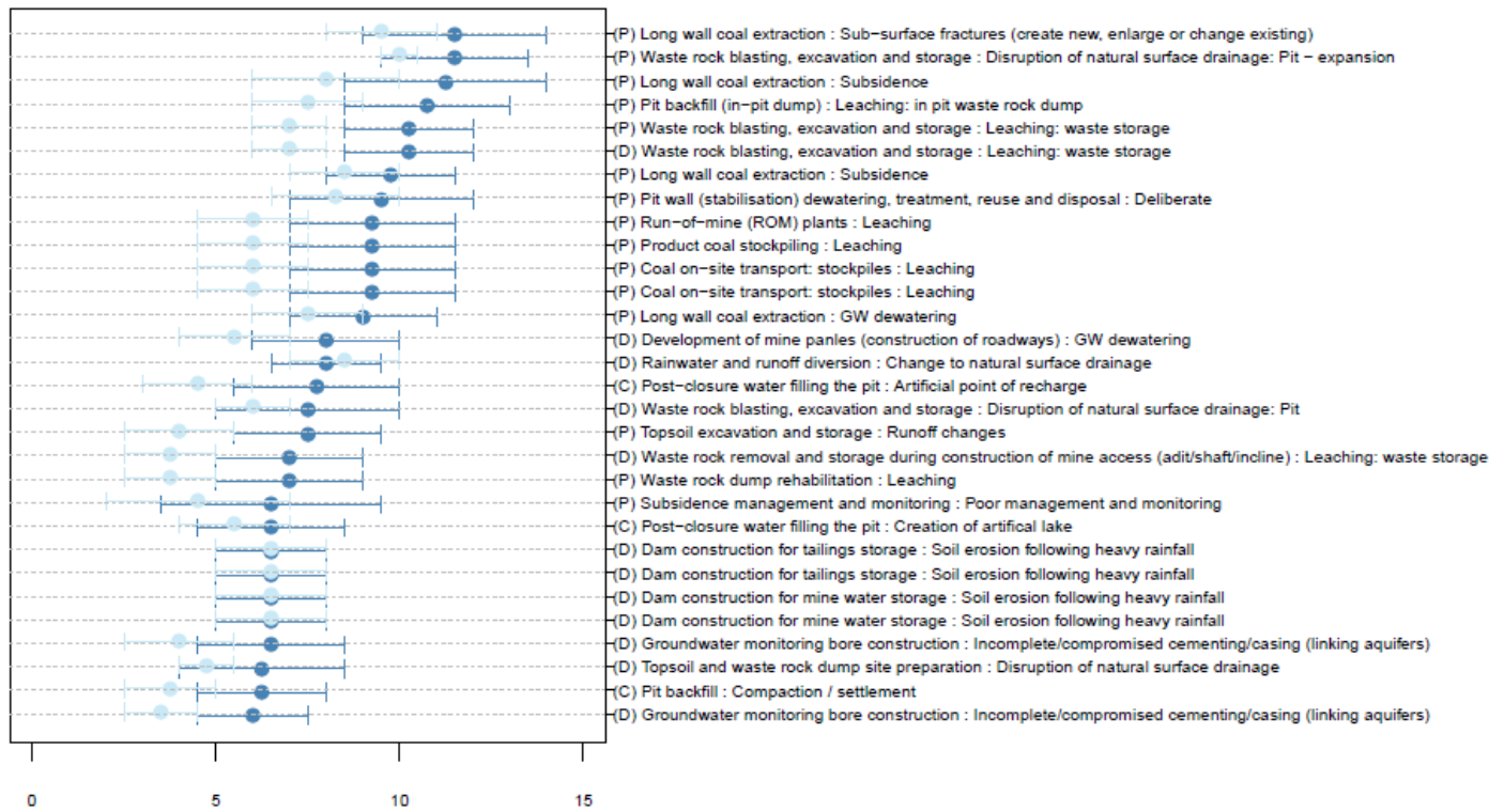
The x-axis shows the hazard priority number and hazard score for potential hazards. The intervals between the highest and lowest hazard priority number are shown in dark blue; the intervals for hazard score are shown in light blue. The same hazard may appear multiple times, as it may arise from a number of different life-cycle stages and activities. Hazards are listed with the syntax [Life‑cycle stage][Activity]:[Impact mode], where life-cycle stages are indicated by (E) for exploration and appraisal, (C) for construction, (P) for production and (D) for decommissioning.
Typology and punctuation are consistent with Dataset 1.
Data: Bioregional Assessment Programme (Dataset 1)
2.3.5.2.3 Hazard handling and scope
A full list of hazards (Bioregional Assessment Programme, Dataset 1) has been generated for both CSG operations and coal mines, as described in Section 2.3.5.2.1 and Section 2.3.5.2.2 This section describes the scope of subsequent work, which addresses only a subset of the full list of hazards.
The hazards of primary focus from a BA perspective are those that extend beyond the development site and that may have cumulative impacts, as these are consistent with the regional focus of BA, and are where BAs will add greater value beyond site-specific environmental impact statements (EIS). Ultimately, however, BAs need to be able to address all identified hazards by considering the scope, modelling, other literature or narratives, and specifying where science gaps may exist.
BAs are constrained by considering only impacts that can happen via water, and so hazards such as dust, fire or noise are deemed out of scope and are addressed by site-based risk management unless there is a water-mediated pathway.
Leading practice is assumed and accidents are deemed to be covered adequately by site-based risk management procedures and are beyond the scope of BA; for example, the failure of a pipeline is covered by site-based risk management.
Hazards that pertain to the development site and with no off-site impacts are important to acknowledge but will typically be addressed by site-based risk management procedures.
For CSG operations, the following hazards are considered out of scope in the Galilee subregion because they are deemed to be covered by site-based risk management and regulation:
- abandonment practice
- hazards addressed by site management, no water-mediated pathway (dust, fire or noise)
- containment failure due to poor construction or design
- equipment/infrastructure failure (e.g. pipeline failures)
- leaching/leaking from storage ponds and stockpiles
- spillages and disposals (diesel, mud, cuttings, fluid recovery)
- vegetation clearance and subsequent soil erosion following heavy rainfall.
Hydrological effects associated with CSG operations that are considered to be in scope are detailed in companion submethodology M05 (as listed in Table 1) for developing a conceptual model of causal pathways (Henderson et al., 2016) and listed below:
- surface water quality
- surface water direction
- surface water flow
- aquifer properties
- groundwater composition
- groundwater flow (reduction)
- groundwater level
- groundwater pressure.
The hydrological effect of an activity such as ‘water and gas extraction’ depends on the impact cause and impact mode. For example, ‘depressurisation’ (impact cause) that causes ‘subsidence’ (impact mode) affects ‘surface water direction’ (hydrological effect) and ‘aquitard leaks’ (impact cause) that cause ‘non-target, non-reservoir aquifer depressurisation’ (impact mode) affects ‘groundwater pressure’ (hydrological effect)
Activities, impact modes and hydrological effects are assigned to a specific series of causal pathways (Table 13, Table 14). A causal pathway describes the logical chain of events – planned or unplanned– that link coal resource development to changes in groundwater or surface water, and then to impacts on water-dependent assets. The various combinations of activities, impact modes and effects have common themes relating to causal pathways. Hence causal pathways can be grouped further into four main causal pathway groups (Table 13, Table 14). The companion submethodology M05 (as listed in Table 1) for developing a conceptual model of causal pathways (Henderson et al., 2016) provides further detail on causal pathways and causal pathway groups that were utilised for BAs.
CSG projects are included in the CRDP but have not been modelled (Section 2.3.4.1). Although cumulative hazards and potential causal pathways by CSG operations are recognised (as noted in Section 2.3.4.1), the timing and nature of future CSG production (beyond small-scale pilot operations) is currently unknown, but unlikely to occur within the next 10 to 15 years.
Table 13 Top 30 coal seam gas (CSG) activities, associated impact modes and causal pathway groups for the Galilee subregion
aLife-cycle stages are indicated by (C) for construction, (E) for exploration and appraisal, (P) for production, (D) for decommissioning and (W) for work-over.
bTable rows are ordered according to component and life cycle.
GW = groundwater, SW = surface water, RO = reverse osmosis
The full list of identified hazards is available from Bioregional Assessment Programme (Dataset 1). Typology and punctuation are consistent with this dataset.
Data: Bioregional Assessment Programme (Dataset 1)
For open-cut and underground coal mines, the following hazards are considered out of scope for the Galilee subregion because they are deemed to be covered by site-based risk management and regulation and do not have cumulative effects on water in the subregion:
- addressed by site management, no water-mediated pathway (dust, fire or noise)
- bore and well construction (integrity, leakage)
- disruption of surface drainage network for site-based infrastructure, plant and facilities, roads, creek crossings
- equipment/infrastructure failure (e.g. pipeline failures, plant failures)
- leaching/leaking from storage ponds and stockpiles
- loss of containment (due to construction or design, slope failure)
- re-contouring, compaction and settlement following backfill
- spillages and disposals (diesel, mud, cuttings, fluid recovery)
- vegetation clearance and subsequent soil erosion following heavy rainfall.
Of those hazards that are in scope, some will be addressed by the BA numerical modelling, while for others (e.g. water quality hazards) it will only be possible through informed narrative. In the full list of hazards (Bioregional Assessment Programme, Dataset 1), the hazard priority number or hazard score indicates the relative importance of the hazard. Hazards with low scores are of lower priority.
Hydrological effects associated with coal mines that are considered to be in scope for the Galilee subregion are listed below:
- surface water quality
- surface water direction
- surface water flow
- surface water volume
- change to zero flow days
- groundwater quality
- groundwater direction
- groundwater flow (reduction)
- groundwater quantity/volume
- groundwater pressure.
Activities, impact modes and hydrological effects for open-cut and underground coal mines are assigned to causal pathways that can be aggregated into causal pathway groups (Table 14). The companion submethodology M05 (as listed in Table 1) for developing a coal resource development pathway (Henderson et al., 2016) provides further detail on causal pathways and their groupings that were utilised for BAs.
Table 14 Top 30 open-cut and underground mine activities, associated impact modes and causal pathway groups for the Galilee subregion
aLife-cycle stages are indicated by (C) for construction, (E) for exploration and appraisal, (P) for production and (D) for decommissioning.
bTable rows are ordered according to component and life cycle.
BA = bioregional assessment, GW = groundwater, SW = surface water
The full list of identified hazards is included in Bioregional Assessment Programme (Dataset 1). Typology and punctuation are consistent with this dataset.
Data: Bioregional Assessment Programme (Dataset 1)
