This section describes the ecological assets in the asset list that were considered to be water dependent. Of the 1272 ecological assets in the asset list, 1131 were deemed to be water dependent for the purposes of the BA. The water-dependent asset register contains 599 assets in the ‘Vegetation’ subgroup, 12 in the ‘Groundwater feature’ subgroup and 520 in the ‘Surface water feature’ subgroup. A more detailed summary of the distribution of assets according to asset class in the asset list is presented in Table 7.
Table 7 Summary of ecological assets within the Gwydir subregion
Data: Bioregional Assessment Programme (Dataset 1)
1.3.2.1.1 Groundwater features
All 12 assets listed in the ‘Groundwater feature (subsurface)’ subgroup were ‘assumed to be water dependent’ and included in the water-dependent asset register for further consideration during the assessment (Table 7). The majority of these groundwater features were aquifers identified in the Water Asset Information Tool (WAIT) database for the Gwydir subregion (Australian Government Department of the Environment, Dataset 2). Three assets were identified as Great Artesian Basin (GAB) recharge areas (Geoscience Australia, Dataset 3) and these are located throughout the eastern part of the subregion (Figure 4).
1.3.2.1.2 Surface water features
All 520 assets listed in the ‘Surface water feature’ subgroup were assumed to be water dependent (Table 7). The main area coverage within the ‘Surface water feature’ subgroup are ‘Floodplain’ and ‘Wetland, wetland complex and swamp’, and these are mostly in the western and north-western parts of the subregion (Figure 4).
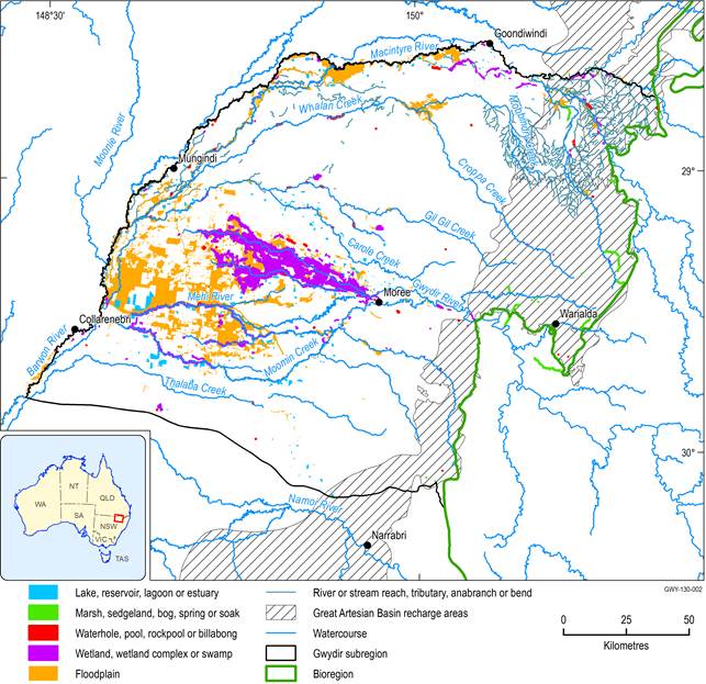
Figure 4 Surface water features and Great Artesian Basin recharge areas in the Gwydir subregion
Some assets are represented multiple times within the asset register. These replicates are retained in each of the overlapping asset databases as boundaries may differ between databases, and to ensure they are assessed separately by each relevant BA and to enable future assessments to potentially aggregate assessment results for the replicated assets across more than one subregion. For example, the Gwydir wetlands, shown as ‘Wetland, wetland complex or swamp’, are also classified as ‘Floodplain’ and ‘Marsh, sedgeland, bog, spring or soak’.
‘River or stream reach, tributary, anabranch or bend’ polygons are not shown in the map as they cover the entire subregion.
Data: Bioregional Assessment Programme (Dataset 1); Australian Government Department of the Environment (Dataset 2, Dataset 6, Dataset 7, Dataset 9); Geoscience Australia (Dataset 3); NSW Department of Environment, Climate Change and Water (DECCW) (Dataset 4); Office of Environment and Heritage (OEH) NSW (Dataset 5); Murray-Darling Basin Authority (Dataset 8)
1.3.2.1.3 Vegetation
Groundwater-dependent ecosystems
All 375 assets identified as groundwater-dependent ecosystems were sourced from the National atlas of groundwater dependent ecosystems (GDE Atlas; Bureau of Meteorology, Dataset 10). A breakdown of the ecological assets identified as being dependent on the surface water expression of groundwater and the subsurface water expression of groundwater is given in Table 8 and their spatial distribution is shown in Figure 5 and Figure 6 respectively. Approximately 34% of the assets were excluded from the water-dependent asset register because they were deemed to have a low likelihood of dependence on either surface or subsurface presence of groundwater (Table 8).
Table 8 Breakdown of groundwater-dependent ecological assets in the ‘Vegetation’ subgroup for the Gwydir subregion
Data: Bioregional Assessment Programme (Dataset 1)
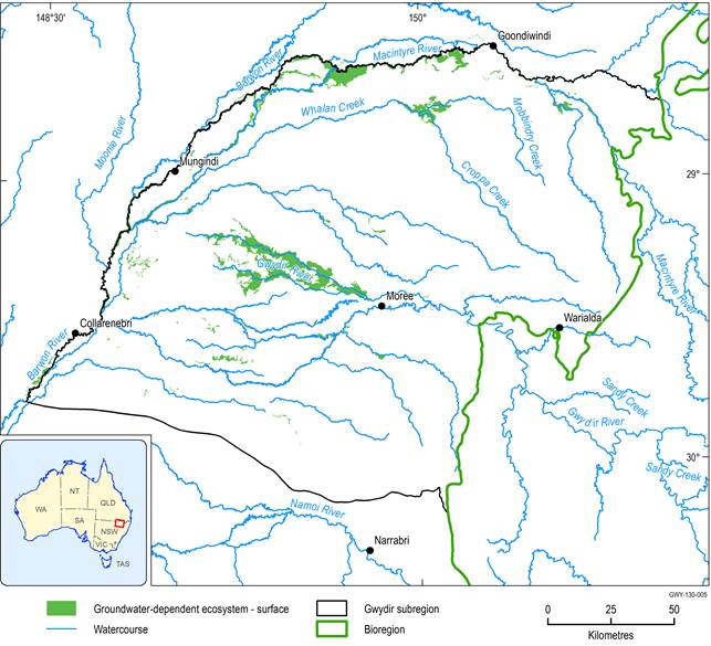
Data: Bioregional Assessment Programme (Dataset 1), Bureau of Meteorology (Dataset 10)
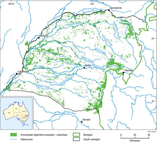
Figure 6 Groundwater-dependent ecosystems that rely on the subsurface presence of groundwater
Data: Bioregional Assessment Programme (Dataset 1), Bureau of Meteorology (Dataset 10)
Habitat (potential species distribution)
Out of a total of 365 assets, 350 assets within the ‘Habitat (potential species distribution)’ asset class were considered to be water dependent (Table 7).
All assets in Collaborative Australian Protected Area Database (CAPAD) areas (Australian Government Department of the Environment, Dataset 11) and in Important Bird Areas (Birds Australia, Dataset 12) were deemed to be water dependent. Of the NSW Government assets, all assets derived from the NSW climate change corridors (Office of Environment and Heritage (OEH) NSW, Dataset 16), native vegetation management areas (NSW Department of Environment, Climate Change and Water (DECCW), Dataset 15), Travelling Stock Route Conservation Values (NSW Department of Environment, Climate Change and Water, Dataset 14), and Gwydir wetlands and floodplains vegetation data (Office of Environment and Heritage (OEH) NSW, Dataset 5) were deemed water dependent.
The remaining assets were either categorised as ‘Threatened ecological communities’, or ‘Habitat of threatened ecological species’.
Threatened ecological communities
Six communities listed under the EPBC Act occur in the Gwydir subregion, and all were deemed to be water dependent (Table 9). ‘White Box-Yellow Box-Blakely's Red Gum Grassy Woodland and Derived Native Grasslands Threatened Ecological Community’ occurs mainly in the eastern part of the subregion. ‘Weeping Myall Woodlands Threatened Ecological Community’ and ‘Coolibah - Black Box Woodlands of the Darling Riverine Plains and the Brigalow Belt South Bioregions Threatened Ecological Community’ are found more to the western part, and ‘Brigalow (Acacia harpophylla dominant and co-dominant) Threatened Ecological Community’ and associated ‘Semi-evergreen vine thickets of the Brigalow Belt (North and South) and Nandewar Bioregions Threatened Ecological Community’ grow throughout the central area of the subregion. The ‘Natural Grasslands On Basalt And Fine-Textured Alluvial Plains Of Northern New South Wales And Southern Queensland’ habitats cover most of area in the subregion (Figure 7).
Table 9 Water-dependent threatened ecological communities in the Gwydir subregion listed under the Commonwealth’s Environment Protection and Biodiversity Conservation Act 1999
aPunctuation and typography appear as used in the asset list.
Data: Bioregional Assessment Programme (Dataset 1), Australian Government Department of the Environment (Dataset 17)
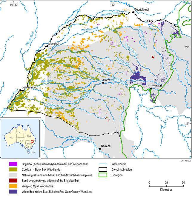
Names in the legend have been shortened. Full names can be found in Table 9.
Data: Bioregional Assessment Programme (Dataset 1), Australian Government Department of the Environment (Dataset 17)
Habitat of threatened ecological species
Thirty-four threatened species listed under the EPBC Act were identified in the Gwydir subregion (Bioregional Assessment Programme, Dataset 13). Of these, 15 were excluded from the water-dependent asset register because a demonstrated surface water or groundwater dependency of the habitat could not be established. The excluded assets include ten plant species, three bird species and two reptile species. Species included in the water-dependent asset register are listed in Table 10.
Table 10 Water-dependent threatened species in the Gwydir subregion listed under the Commonwealth’s Environment Protection and Biodiversity Conservation Act 1999
Although examples of individual species are listed, bioregional assessments consider the potential impacts to the habitat of the species not the individual species per se.
Data: Bioregional Assessment Programme (Dataset 1)
aPunctuation and typography appear as used in the asset list.
NA = not available
The asset list and other details are available from the water-dependent asset register and asset list (Bruce and O'Grady, 2016) and the asset database (Bioregional Assessment Programme, Dataset 1).
