1.1.4.1.1 Hydrogeological characteristics of the Gloucester Basin formations
Based on the geological setting and discrete structural-sedimentary formation (see Figure 22 and 23, Chapter 1.1.3), the Gloucester Basin which underlies the Gloucester subregion, is characterised as a closed hydrogeological system. Multiple groundwater studies (Australasian Groundwater and Environmental, 2013; Heritage Computing, 2009; 2012; Parsons Brinckerhoff, 2012a; 2012b; 2012c; 2013b) describe four main hydrogeological units within the basin:
- the alluvial aquifers along major creek lines
- relatively shallow weathered/fractured rock aquifers
- interburden units of very low permeability which form a thick succession of low permeability coal measures
- the impermeable Alum Mountain Volcanics Formation that underlies these three hydrogeological units.
Findings of the studies (Australasian Groundwater and Environmental, 2013; Heritage Computing, 2009; 2012; Parsons Brinckerhoff, 2012a; 2012b; 2012c; 2013b) are summarised below:
- The alluvial aquifer (unconfined or semi-confined) (Quaternary deposits as shown in Figure 25) developed in close proximity to the river. It is composed of clay layers and highly permeable sediments (e.g. gravel) with a high range of hydraulic conductivity (K = 0.3 to 500 m/day). The alluvial thickness is 15 m or less in the northern part of the basin where most of AGL Energy Limited’s (AGL) groundwater investigation was undertaken (Parsons Brinckerhoff, 2012a) and an average of about 9 m at the Duralie Coal Mine (DCM) area, located in the southern part of the Gloucester Basin (Heritage Computing, 2009). The watertable is shallow and within the first metres of the area close to the river. The water levels are very responsive to rainfall and flooding events (see Figure 5 Parsons Brinckerhoff, 2013d, p. 6).
- The fractured rock aquifer, which underlies the alluvial systems but also extends to the entire area of the Gloucester Basin, is hosted by the top 150 m (see Figures B-16 and B-17 Heritage Computing, 2009, pp. B-68 to B-70) of the weathered profile across all shallow stratigraphic units (i.e. shallower than 150 metres below ground level (mbgl)) (Permian Formation as shown in Figure 25). This aquifer, confined locally, is of lower hydraulic conductivity (K = 0.01 to 20 m/day). There is a limited and delayed groundwater level response to rainfall seasons, however the groundwater response to the individual rainfall events is not commonly observed (see Figures A-6, A-7, A-9, A-10, A-13 to A-20, A-24 to A-26, A-29, A-30 Parsons Brinckerhoff, 2013d, p. 10 to 22). Parsons Brinckerhoff (2013b) reported that the shallow rock hydrogeological unit comprises inter-bedded sandstone, silt and claystone. This aquifer extends beneath the alluvium where present, and outcrops elsewhere in the Gloucester Basin. Also, the hydraulic properties are likely to be largely controlled by bedding plane fractures. The 150 mbgl zone of shallow rock is heterogeneous, with high and low hydraulic conductivity domains associated with fault zones and fracturing (Parsons Brinckerhoff, 2013b). The known aquifer zones occur to a maximum depth of 150 m but are mostly within less than 100 m.
- In addition to these two aquifer systems, SRK (2010) refer to deeper coal measures, including coal seams, as ‘water-bearing’ rather than ‘aquifers’, implying that they are low water yielding strata. However, Parsons Brinckerhoff (2012a) sometimes refer to coal seams as aquifers with hydraulic conductivity (K = 0.002 to 0.03 m/day). Changes in hydraulic conductivity of these formations with depth are characterised by a linear logarithmic decrease (see Figure 4-9 in Parsons Brinckerhoff, 2013b; SRK, 2010 or Figures 5.6 and 5.7 in Parsons Brinckerhoff) ~ 8.6 x 10² m/day at 100 m; ~ 6.1 x 10² to ~ 2.3 x 10³ m/day at 300 m, and ~ 4.8 x 10⁴ m/day at 500 m. Similar hydraulic conductivity values were also reported by Australian Groundwater and Environmental Consultants (AGE) for the DCM (see Tables B-4 (pp. B-19) and B-10 (pp. B-28) in Heritage Computing, 2009). It was also noticed that this relationship in the Gloucester Basin is similar to those in the Hunter Valley and Sydney Basin (see Figure 3.5 (pp. 22) in Ward and Kelly, 2013). No response to recharge events (rainfall) and very little fluctuation were observed in the bores in these strata. However changes in groundwater level (or heads) were identified in response to more general seasonal trends in rainfall (dry versus wet periods). The coal seams vary in thickness from 3 to 18 m, have relatively high permeability (as compared to the surrounding interburden) and hence are likely to form potential conduits for limited groundwater flow at depth.
- The Alum Mountain Volcanics Formation, which is considered to be impermeable, underlies the Permian Coal Measures. This formation outcrops in the east and west of the Gloucester Basin, forming the Gloucester River and Barrington Tops to the west, and the Mograni Range to the east. Parsons Brinckerhoff (2013b) suggested that there are springs along the margins of the basin, assumed to be associated with circulation of meteoric water through localised fractures in shallow parts of the Alum Mountain Volcanics Formation.
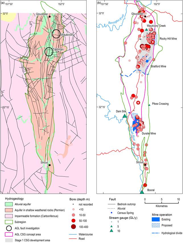
Figure 25 Hydrogeological information
1.1.4.1.2 Fault systems and their hydrogeological characteristics
A large number of faults are known or inferred to underlie the Gloucester Basin (Figure 25) (Roberts et al., 1991). However, the effect of faults on hydraulic properties of formations is not well known. Some evidence of the role of fault systems on hydraulic properties of the formations in the basin are summarised by Parsons Brinckerhoff (2012c; 2013b). Key findings are listed below:
- Pacific Power (1999, in SRK (2010)) reported that an inferred normal fault, intersected at 325 mbgl (the Bowens Road Coal Seam) showed hydraulic conductivity of approximately 5.8 x 10⁻² m/day, approximately one order of magnitude higher than that estimated for coal seams at a similar depth (~ 8.6 x 10⁻³ to 1.2 x 10⁻² m/day).
- Resource Strategies (2001) suggested that faulting caused compartmentalisation of groundwater flow (i.e. faults are of low permeability) (from URS, 2007, p. 14).
- Parsons Brinckerhoff (2012a) observed that groundwater monitoring data collected from bores near faults or which straddle fault zones do not indicate any effect of the faults on the natural groundwater flow characteristics of shallow rock aquifers, interburden confining units or coal seam water-bearing zones.
- The results of the site-specific investigations, field-based studies and geophysical methods summarised in Parsons Brinckerhoff (2013b) indicate that one of the strike-slip fault zones (the Tiedman property) forms a broad and heterogeneous zone of increased hydraulic conductivity within the shallow rock aquifer. This zone does not cause a strong preferred longitudinal flow along the faulting zone or form a barrier to groundwater flow. No clear evidence of enhanced connections between the deeper coal seams and shallow groundwater system was found. However distinct hydrochemistry and radiocarbon (older) ages within the fault zone were also reported, which may be indicative of some vertical (upward) migration of deeper groundwater under natural conditions.
AGL plans to conduct a further hydrogeological investigation into faulting in association with the proposed Waukivory flow testing program. The thrust fault in the Waukivory area is typical of many fault systems across the eastern portion of the Gloucester Basin (see Figure 3.7 in Parsons Brinckerhoff, 2013c, p. 16).
1.1.4.1.3 Groundwater use
According to the New South Wales Office of Water (NSW Office of Water), data for registered bores in the Gloucester Basin are categorised by use as: commercial or industrial; irrigation; mining; stock, domestic or farming; test or monitoring; and unknown.
Parsons Brinckerhoff (2013c) and Australasian Groundwater and Environmental (2013) provided a review of the NSW Office of Water groundwater database for the Gloucester Basin. Parsons Brinckerhoff (2013c) have identified registered bores: 24 used by stock and domestic supply; four used for irrigation; five used for commercial and industrial purposes; four for mining use; 121 for test and monitoring associated with mining in the area; and 30 are registered with unknown use.
Stock and domestic useThe 24 bores registered for stock and domestic use are between 4 m and 66 m deep and are likely to intersect the alluvium and shallow rock within the Gloucester Basin. Parsons Brinckerhoff (2013c) assumes that annual stock and domestic bore use is approximately 1 ML/bore. AGE (2013) has reported that a single groundwater facility exists in the Avon River management area with an annual entitlement of 20 ML/year from the alluvium.
Coal mining
There are 51 bores associated with Stratford Mine, Duralie Mine and the Rocky Hill Coal Project. Groundwater pit inflows to the Duralie Mine open cuts are expected to vary between approximately 0.2 and 1ML/day during mining operations (Heritage Computing, 2009, pp. B-5). Total pit inflows will range between approximately 0.7 ML/day and 1.3 ML/day during the Stratford Mine operation (Heritage Computing, 2012, p. A-47 and A-56). Pit inflows are predicted to be reduced by a maximum of 0.5 ML/day if CSG dewatering in the Stage 1 Gas Field Development Area is coincident with mining at the Stratford Mine (Heritage Computing, 2012, p. A-49 and A-54).
Coal seam gas
Over the last 10 years, AGL and Lucas Energy were the only organisations which conducted CSG exploration and relevant hydrogeological investigations in the Basin and the findings of those activities were summarised by Parsons Brinckerhoff (2013c). According to Parsons Brinckerhoff (2013c):
- Coal seam gas dewatering is deemed to be ‘industrial and irrigation use’ as water that is pumped as part of exploration (appraisal) and production programs is mostly reused (for drilling, fracture stimulation, industrial recycling and irrigation purposes).
- The long-term reuse of water produced as a result of CSG dewatering will mostly be for irrigation purposes. This would be conditional on water quality, which is likely to be brackish.
- The Gloucester Gas Project (GGP) will involve the dewatering of deep groundwater and the extraction of gas from multiple coal seams within the Gloucester Coal Measures. Target coal seam depths will vary from site to site but are expected to range between 200 and 1000 mbgl.
- The GGP includes the construction, operation and decommissioning of not more than 110 coal seam gas wells and associated infrastructure, including gas and water gathering lines, within the Stage 1 Gas Field Development Area.
- The volumetric rate of groundwater extraction will not exceed 2 ML/day (averaged over a 12 month period), as specified in the Commonwealth’s Environment Protection and Biodiversity Conservation Act 1999 (the EPBC Act; Part 3A Approval – condition 3.11; and EPBC Approval – condition 22). The effect of such abstraction on the basin water balance has not yet been fully assessed.
Planning and management of groundwater systems in the region is undertaken by the NSW Office of Water, through water sharing plans (WSP) and reviewed every 10 years from date of commencement. Currently there is no WSP for the sedimentary (porous) rocks of the Gloucester Basin. As per NSW Office of Water, Water Sharing Plan website development of Northern Fractured and Porous Rock Groundwater Sources WSP will be commenced in 2014 (DPI, 2014). The WSP for the Karuah River Water Source (DIPNR, 2004) indicated no plans for groundwater extraction. The unregulated Avon River as well as the Barrington and Gloucester rivers and the associated alluvial groundwater source are managed under the Lower North Coast Unregulated and Alluvial Water Sources Water Sharing Plan (DPI, 2009). As per this WSP there are 212 ML/year under groundwater extraction licences, authorising extraction for irrigation from these water sources, including the following:
- 20 ML/year in the Avon River Water Source
- 5 ML/year in the Lower Barrington/Gloucester Rivers Water Source
- 187 ML/year in the Manning Estuary Tributaries Water Source and
- 0 ML/year in all other water sources.
- The licensed extraction is from the alluvial aquifer, and the purpose of use may not always be solely for irrigation, although licensed irrigation use would likely be a major component of usage in some water sources.
