There are several points at which the surface water modelling (Viney, 2016) and groundwater modelling need to be integrated. These include the fate of co-produced CSG water and mine water make, stream depletion due to watertable drawdown, and losing streams.
6.1 Co-produced water and mine water make
The groundwater extracted for dewatering coal mines (water make) or de-pressurising coal seams (co-produced water) needs to be routed somewhere; this will occur through the surface water modelling (Viney, 2016). The water make or co-produced water will be disposed of in a number of ways, including (i) process water on site, (ii) water use for irrigation, (iii) route water along stream channels or (iv) truck water off site.
6.2 Surface water – groundwater integration with a river model
Some of the considerations necessary are that the river and groundwater models need to be developed concurrently and ideally have a common development time frame. River models are calibrated using stream gauges without considering constraints related to groundwater. While previous generations of river models have lumped groundwater interactions into unallocated losses, the Australian Water Resources Assessment (AWRA) river model (AWRA-R) is capable of attributing river losses to various places but the groundwater losses are not constrained by groundwater data. In most semi-arid areas, river losses to groundwater are a substantial part of the groundwater balance and the groundwater model performance is very sensitive to errors. In other areas river losses to groundwater are often a small part of the river reach water balance, so the calibration is not sensitive to errors in the losses to groundwater.
A series of recommendations were made by Rassam et al. (2008) on improving the way that river models and groundwater models were coupled during the Murray-Darling Basin Sustainable Yields Project (CSIRO, 2008). The lessons learnt during that project will need to be incorporated into the modelling for BA. The general methodology is a three-stage process (Figure 9):
- A river model is used to provide river stages to a groundwater model.
- A groundwater model is run using the river stages to calculate exchange fluxes between groundwater and the river.
- The river model is run again with the updated exchange fluxes calculated by the groundwater model. It is assumed that the change in baseflow fed back to the river has a very small impact on the river stage and so the proceeding steps do not need to be repeated.
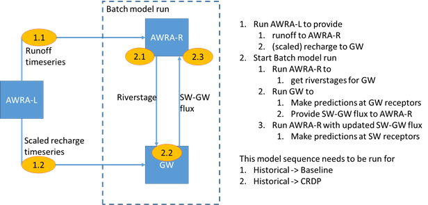
Figure 9 Schematic of model run sequencing between the landscape, river and groundwater models
6.3 Surface water – groundwater integration without a river model
In bioregional assessment (BA) subregions or bioregions that will not include the development of a river model, the modelling of surface water – groundwater interactions will be limited. The AWRA-L landscape model outputs will be used to generate runoff rates for all BA subregions or bioregions, which will subsequently be aggregated to model nodes. However, the river stage variable (which is the boundary condition of interest for groundwater models) will not be calculated and so changes in river flow will not result in variations in surface water – groundwater fluxes.
For gaining streams and rivers, watertable declines due to groundwater extraction can result in reductions in baseflow. This requires that the stream network is built into groundwater models where there is a model node located on that stream segment. Differences in baseflow calculated by the groundwater model, between the baseline and coal resource development pathway (CRDP), will need to be subtracted from the runoff rates obtained from the Australian Water Resources Assessment (AWRA) landscape model (AWRA-L) for the baseline so that the impact on the model nodes associated with surface water can be determined in the CRDP.
For losing-connected streams and rivers the impacts of a falling watertable will result in increased river losses. These changes in river losses can be calculated by the groundwater model and subtracted from the aggregated runoff at the model node.
