The impact and risk analysis (Box 7) used multiple lines of evidence to investigate how hydrological changes due to additional coal resource development may affect water-dependent assets, such as bores, heritage sites, or habitats of species.
More than 4200 assets were listed for the Galilee subregion, comprising more than 800,000 individual elements (Sparrow et al., 2015; Bioregional Assessment Programme, 2017; Dataset 3). Many of these assets are large, such as the Diamantina National Park in south-west Queensland, which covers an area of 5070 km2.
A total of 4262 assets were assessed as being water dependent, including:
- 3982 ecological assets, of which 241 are in the zone of potential hydrological change
- 129 economic assets, comprising 5012 surface water and groundwater access entitlements, which are aggregated into 96 groundwater economic assets and 33 surface water economic assets
- 151 sociocultural assets, including historical places associated with the ill-fated 19th century expedition of Burke and Wills, and Indigenous assets of cultural significance.
Potential impacts on most water-dependent assets were assessed by overlaying their extent on the zone of potential hydrological change (Box 5, Figure 1), defined using the near-surface aquifer and some streams. However, the potential impacts to some groundwater economic assets sourced from the confined aquifer of the Clematis Group were assessed using the area with at least a 5% chance of 0.2 m of drawdown in the deeper Clematis Group model layer.
The assessment identified potential impacts if an asset or any part of it is within the zone. Assets with areas that exceed thresholds of hydrological change (defined in Box 11) are identified as ‘more at risk of hydrological changes’ relative to other assets.
Ecological changes were not predicted for assets, because receptor impact models (Box 9) were developed for landscape groups and not individual assets. However, an example of a more detailed analysis of a specific asset (‘potential distribution of Black Ironbox (Eucalyptus raveretiana)’) is provided in Lewis et al. (2018) to illustrate the type of approach that could be used to assess impacts at a finer level of detail.
Parts of some assets were deemed ‘more at risk of hydrological changes’ relative to other parts of that asset. Categorisation assists the rule-out process and in identifying where further local-scale assessment is warranted. Assessment units that overlap with an asset are categorised as ‘more at risk’ based on the degree that modelled hydrological changes exceed thresholds of risk. These bioregion-specific thresholds are based on expert opinion and defined using hydrological response variables (see Section 3.5 of Lewis et al. (2018) for more details on the thresholds).Box 11 Categorising risk for assets
Ecological assets
Which ecological assets are very unlikely to be impacted?
Of the 3982 ecological water-dependent assets in the Galilee assessment extent, 3741 (94%) are outside the zone of potential hydrological change and thus are very unlikely to be impacted.Key finding 12
None of the ecological assets outside of the zone are interpreted to source water from either of the deeper aquifers modelled for this assessment (Clematis Group and upper Permian coal measures aquifers), as they are too deeply buried and overlain by a significant thickness of sedimentary rocks (400 to 1200 m), including regional aquitard layers such as the Moolayember Formation.
For more details see Table 30 in Section 3.5.2 of Lewis et al. (2018).
Which ecological assets are potentially impacted?
Of the 241 ecological assets in the zone, the majority (67%) is groundwater-dependent vegetation, distributed along streams such as Cape River, Carmichael River, Cattle Creek, Dyllingo Creek, Fox Creek, Lagoon Creek, Native Companion Creek, North Creek, Sandy Creek, Suttor River and Tomahawk Creek.
Of the 241 water-dependent ecological assets in the zone of potential hydrological change, 148 are ‘more at risk of hydrological changes’ (Box 11). Most of these assets are groundwater-dependent ecosystems or potential habitat of threatened species.Key finding 13
The assets that are ‘more at risk of hydrological changes’ include 106 GDEs as well as potential habitat for 12 threatened species listed under the EPBC Act, including:
- two endemic spring wetland plants: the blue devil and the salt pipewort (Figure 67 in Lewis et al. (2018))
- three species of seed-eating birds: the black-throated finch (southern), star finch (eastern) and squatter pigeon (southern) (Figure 68 in Lewis et al. (2018))
- the koala
- four reptile species.
Two EPBC Act-listed threatened ecological communities, seven regional ecosystems listed under Queensland‘s Nature Conservation Act 1992, and four parks and reserves are also deemed ‘more at risk of hydrological changes’.
Of all ecological assets in the zone, 48 (20%) are in the ‘Springs’ landscape group, mostly in the Doongmabulla Springs complex. The 200 springs in this landscape group occupy less than 1% of the area of the zone.
Two alternative groundwater model conceptualisations applied in this assessment predict that 181 of the 187 springs in the Doongmabulla Springs complex both have a 5% chance of experiencing additional groundwater drawdown in excess of 0.2 m (for the Clematis Group aquifer which is interpreted to be the source aquifer for these springs). Expert ecological knowledge suggests that this level of drawdown is predicted to impact the ecological functioning of some ecological assets; however, there will be considerable variation in response across springs and spring complexes. Higher resolution modelling using local-scale information is needed to improve the assessment of potential impacts and risks to springs in the zone.
Section 3.6 of Lewis et al. (2018) provides a qualitative assessment of potential impacts to water-dependent ecosystems and assets due to the ten non-modelled additional coal resource developments in the CRDP (seven coal mine projects and three CSG extraction projects).
Economic assets
The groundwater and surface water resources in the central-eastern Galilee subregion are used for a variety of economic purposes: town water supplies, stock and domestic use, and minor irrigation. Find out more about the subregion’s water use in Evans et al. (2015). Many bores in the GAB extract groundwater from deeper confined aquifers (i.e. not the near-surface aquifer), and most of the water-dependent economic assets in the Galilee assessment extent are associated with the GAB. Therefore, the impact analysis of economic assets is based on the framework of groundwater management areas and units defined in the Water Plan (Great Artesian Basin) 2006 (although this plan was superseded in September 2017 by the new Water Plan (Great Artesian Basin and Other Regional Aquifers) 2017).
The groundwater model (Box 3) estimated drawdown due to additional coal resource development for three aquifer layers:
- Quaternary alluvium and Cenozoic sediments – the geologically young, near-surface aquifer that mainly hosts the watertable within the zone of potential hydrological change (Figure 15)
- Clematis Group aquifer – outcropping west of the seven modelled mines, this unit forms a deeper confined aquifer that provides water for stock and domestic bores in the Barcaldine North 3 and Barcaldine East 4 groundwater management units
- Upper Permian coal measures – the main geological unit that contains the coal resources targeted for mining in the CRDP.
The Clematis Group is the main aquifer associated with groundwater economic assets that are potentially impacted due to modelled additional coal resource development. For this aquifer, the area with at least 5% chance of exceeding 0.2 m drawdown extends further west than the boundary of the zone of potential hydrological change, defined for the near-surface aquifer (Figure 16).
Which economic assets are very unlikely to be impacted?
About 95% of the 129 economic assets in the Galilee assessment extent are outside the zone of potential hydrological change. In addition, most economic assets that source groundwater from the deeper confined aquifer of the Clematis Group are also outside the area of the Clematis Group drawdown zone (defined using a similar threshold of a 5% chance of 0.2 m drawdown for the Clematis Group). No economic assets source groundwater from the deeper upper Permian coal measures layer. Economic assets that are very unlikely to be impacted include:
- all of the economic assets associated with eight of the ten groundwater management areas of the GAB that intersect the subregion, including the Barcaldine North, Barcaldine South and Flinders groundwater management areas
- all 25 of the surface water access rights that intersect with the assessment extent, including the 2 water access rights associated with the Water Plan (Burdekin Basin) 2007.
Which surface water economic assets are potentially impacted?
One basic water right on the Belyando and Suttor rivers is the sole surface water economic asset in the zone of potential hydrological change. There is a 5% chance of annual flows reducing by around 1% and of zero-flow days increasing by a maximum of between 152 and 260 days per year at the three extraction points associated with this water right.Key finding 14
The basic surface water right has three water extraction locations in the zone: two on the Belyando River and one on its headwater tributary, Native Companion Creek (Figure 15). This is the single surface water economic asset managed under the Water Plan (Burdekin Basin) 2007. The extraction point on Native Companion Creek is not expected to experience significant changes in annual flow volume, as all predictions are below the 1% threshold. However, there is potential for large increases in the number of zero-flow days at this location. It is very likely that zero-flow days will increase by a maximum of at least 2 days per year, and very unlikely that they will exceed a maximum increase of 152 days (with a 50% chance of a 14-day increase).
At the two locations on the Belyando River, the hydrological changes are greater. Reductions in annual flow remain relatively low, only just exceeding 1% (with a 50% chance), but zero-flow days are expected to increase at both sites, with a 50% chance of a maximum increase of more than 50 days per year. There is a 5% chance of very large increases of similar magnitude (around 260 days) in both cases.
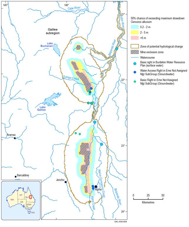
The surface water economic asset has three separate water extraction points shown, whereas the two unassigned groundwater economic assets have multiple bore locations. The term ‘Eme’ in the name of the two economic assets refers to Emerald, the location of the nearest regional office that is responsible for management of the Queensland Groundwater Database (DNRM, 2015).
Data: Bioregional Assessment Programme (Dataset 1, Dataset 3, Dataset 17)
Which groundwater economic assets are potentially impacted?
Preliminary spatial analysis of bores in and near to the zone of potential hydrological change indicated two groundwater management areas of the GAB that are potentially most affected by drawdown due to modelled additional coal resource development, Barcaldine East Groundwater Management Area and Barcaldine North Groundwater Management Area.
The Clematis Group aquifer is the main hydrogeological unit managed in both these groundwater management areas under the Water Plan (Great Artesian Basin) 2006 and is potentially impacted by drawdown (Table 3).
Five groundwater economic assets are potentially affected by additional drawdown, including three associated with the Clematis Group aquifer, and one associated with the Jericho town water supply. It is very unlikely that there will be drawdown greater than 2 m in any economic assets that rely on the Clematis Group aquifer.Key finding 15
Three economic assets specifically associated with the Clematis Group aquifer are potentially affected by drawdown due to modelled additional coal resource development in the subregion:
- a basic water right in Barcaldine East 4 Groundwater Management Unit
- a basic water right in Barcaldine North 3 Groundwater Management Unit
- a water access right in Barcaldine North 3 Groundwater Management Unit.
A basic water right is the right to take water for domestic and stock purposes only, whereas a water access right requires a licence both for the works and the extraction of water for irrigation, mining and intensive agriculture (see Section 2.2 in Mount et al. (2015) and Section 1.3.1.2.2 in Sparrow et al. (2015)).
No asset-related bores associated with these groundwater management units are expected to experience greater than 2 m of drawdown due to modelled additional coal resource development. Only a relatively small area to the west of China Stone and Carmichael has a 5% chance of experiencing more than 2 m of drawdown in the Clematis Group aquifer, but no economic assets are identified for this location. This area of greater than 2 m drawdown in the Clematis Group aquifer is shown in yellow in Figure 16c.
The other two potentially impacted groundwater economic assets are not assigned to a specific management unit and include one water access right and one basic water right (for bore locations see Figure 15). Several bores in the water access right economic assets are associated with the Jericho town water supply. These bores source groundwater from the Clematis Group aquifer and it is very unlikely that any will experience more than 2 m of drawdown.
Not all groundwater bores recorded in the Queensland bore database (Queensland Government, 2018) are associated with the groundwater economic assets in the water-dependent asset register (Bioregional Assessment Programme, 2017; Dataset 3). For example, there may be some bores drilled after the register was compiled, and other bores owned by various mining companies in the Galilee subregion were not initially available for inclusion. Find out more in Section 3.5 of the impact and risk analysis (Lewis et al., 2018).
Table 3 Impacts of modelled additional coal resource development on groundwater-dependent economic assets that source the Clematis Group aquifer (95%, 50% and 5% chance of exceeding given values of drawdown)
Additional drawdown is the maximum difference in drawdown under the coal resource development pathway and the baseline (Box 1 and Box 4). Because there are no coal resource developments in the baseline for the Galilee subregion, the CRDP includes only the additional coal resource development (ACRD). Results are shown as percent chance of exceeding drawdown thresholds (Box 6). These appear in Lewis et al. (2018) as percentiles.
Although multiple aquifers are managed under each of the management units listed here, the groundwater modelling for this assessment only generated results for the Clematis Group aquifer. There is one water access right in the Barcaldine North 3 Groundwater Management Unit that occurs within the area of predicted drawdown greater than 0.2 m in the Clematis Group aquifer.
Data: Bioregional Assessment Programme (Dataset 1)
The groundwater component of the zone of potential hydrological change (brown line) was defined by drawdown in the near-surface aquifer (see Box 5), not the deeper Clematis Group aquifer. Additional drawdown is the maximum difference in drawdown under the coal resource development pathway and the baseline (Box 1 and Box 4). Because there are no coal resource developments in the baseline for the Galilee subregion, the CRDP includes only the additional coal resource development (ACRD). Results are shown as percent chance of exceeding drawdown thresholds (Box 6). These appear in Lewis et al. (2018) as percentiles.
The term ‘Eme’ as used in the name of the two economic assets that are not assigned to a specific groundwater management unit refers to the location of the nearest regional office to these bores (which is situated in the town of Emerald) that is responsible for management of the Queensland Groundwater Database (DNRM, 2015).
Data: Bioregional Assessment Programme (Dataset 1, Dataset 3, Dataset 17)
Bores where ‘make good’ provisions might apply
In Queensland, ‘make good’ obligations for groundwater bores affected by coal resource extraction (as well as other types of extractive industries) apply under Queensland’s Water Act 2000 (see Section 3.5.3.3.2 of Lewis et al. (2018)).
None of the groundwater-dependent economic assets sourced from the Clematis Group aquifer are predicted to experience drawdown greater than 2 m (Table 3). As the Clematis Group is a consolidated rock aquifer, the relevant bore trigger threshold under Queensland legislation is a decline in the aquifer water level of 5 m. Consequently, none of the economic assets associated with the Barcaldine North and Barcaldine East groundwater management areas are expected to be impacted at a level that would trigger the need for ‘make good’ provisions to be negotiated.
The town water supply bores for Jericho, classed as part of an unassigned economic asset for this assessment, are sourced from the Clematis Group aquifer. They occur in an area where all modelling results show a 5% chance of a maximum drawdown of about 0.6 m. This suggests that any groundwater impacts at the Jericho town water supply due to modelled additional coal resource development are unlikely to exceed specified bore trigger thresholds.
The town water supply bores at Alpha also occur within the zone of potential hydrological change (for the near-surface aquifer). However, groundwater modelling outputs for this assessment were not able to accurately predict water level changes for these bores, as their alluvial source aquifer is interpreted to be in direct connection with the basal Joe Joe Group of the Galilee Basin. As this hydrogeological connection is not represented in the groundwater model for the Galilee subregion, it is not possible to evaluate the potential for groundwater bore impacts to adversely affect the Alpha town water supply (see Section 3.5.3 of Lewis et al. (2018)). As potential impacts cannot be ruled out on basis of this assessment, further local-scale hydrogeological investigations are needed to develop an appropriate management response for the Alpha town water supply.
Sociocultural assets
The water-dependent asset register for the Galilee subregion lists 151 sociocultural assets with some level of dependency on either groundwater and/or surface water resources. All are either classed as heritage sites or Indigenous sites.
Most sociocultural assets in the Galilee assessment extent are from the Register of the National Estate, although there are also some assets from the National Heritage List and a single entry from the World Heritage List (Great Barrier Reef World Heritage Area).
The water-dependent asset register for the Galilee subregion is available at Bioregional Assessment Programme (2017). The register includes 69 culturally significant Indigenous sites or species within the Galilee assessment extent that were added following consultation with local Indigenous groups. This included 24 species of fauna and flora that are of critical cultural heritage value, all of which may be water dependent. However, as there was no spatial information associated with these assets, it was not possible to determine if they occur within the zone of potential hydrological change (see Section 3.5.4 in Lewis et al. (2018)).
The results of the Indigenous assets consultation are documented in a separate report (Constable and Love, 2014).
Which sociocultural assets are very unlikely to be impacted?
More than 95% of the sociocultural assets in the water-dependent asset register are not in the zone of potential hydrological change, indicating that impacts are very unlikely. These include notable sites such as the Great Barrier Reef World Heritage Area and the national heritage-listed icons of the Simpson Desert and the Birdsville and Strzelecki Tracks Area.
Which sociocultural assets are potentially impacted?
Parts of four heritage or Indigenous sites are in the zone of potential hydrological change:
- Doongmabulla Springs – natural indicative place (Register of the National Estate)
- Lake Buchanan and catchment – natural registered place (Register of the National Estate)
- Old Bowen Downs Road – historic indicative place (heritage site) listed on the Register of the National Estate
- Cape River – surface water feature specified as an Indigenous site during consultation with Indigenous people about water values in the Galilee subregion.
Potential impacts on Doongmabulla Springs are discussed in the ecosystem and ecological assets sections of this synthesis, Lake Buchanan is discussed in Section 3.5.4.2 in Lewis et al. (2018), and impacts on the Old Bowen Downs Road are assessed as being minimal, with modelled predictions suggesting a minor reduction in the number of high-flow days at the river crossings (Section 3.5.4.3 in Lewis et al. (2018)). The Cape River Indigenous asset is only included here, as 1.4 km of the Cape River occurs in the zone of potential hydrological change at its most downstream junction with the Suttor River. However, surface water modelling for this assessment confirmed that modelled additional coal resource development is very unlikely to impact the Cape River.
Explore potential impacts on water-dependent assets in more detail on the BA Explorer, available at www.bioregionalassessments.gov.au/explorer/GAL/assets. It is important to note that when viewing impacts to economic assets using the BA Explorer, drawdown is shown only for the near-surface aquifer and not the deeper confined aquifers that may be the source of water for some bores and springs. Description of the water-dependent asset register, product 1.3 (Sparrow et al., 2015) Water-dependent asset register (Bioregional Assessment Programme, 2017) Impact and risk analysis, product 3-4 (Lewis et al., 2018) Compiling water-dependent assets, submethodology M02 (Mount et al., 2015) Impacts and risks, submethodology M10 (Henderson et al., 2018)FIND MORE INFORMATION
