The causal network is used to identify potential impacts on protected fauna and flora in the Cooper GBA region. Assessment results can be used to identify existing avoidance and mitigation strategies and to prioritise local-scale assessment, mitigation and monitoring. Existing key threatening processes could be amplified by pathways of ‘potential concern’ identified by the assessment. Potential impacts at the surface include contamination, competition and predation, ecosystem burning, habitat degradation, fragmentation and loss, and reduced flooding. The assessment is supported by analysis of remote sensing data and tools for natural capital accounts ( Box 10 , Box 11 ).
The biodiversity-rich Cooper GBA region provides potential habitat for 68 species protected under state or national legislation. The assessment prioritised 12 protected species (4 birds, 3 mammals and 5 plants) based on the importance of the Cooper GBA region to each species in order to better understand potential impacts of unconventional gas resource development on protected fauna and flora.
The Cooper GBA region is very biodiverse. Its boom-and-bust ecology is a key driver of the region’s biodiversity that, to date, includes over 2,000 species (Atlas of Living Australia, 2019). Modelling of biodiversity persistence in the region ( Box 10 ) indicates that the relatively intact landscape can support relatively high biodiversity (greater than 0.9; Figure 15 ) and that trends in vegetation condition are relatively stable (Geological and Bioregional Assessment Program, 2021n). The Cooper GBA region provides potential habitat for 68 species protected under state or national legislation – 38 birds, 2 fish, 10 mammals, 15 plants and 3 reptiles. Many of the region’s species are also culturally significant. For example, the iconic river red gum ( Eucalyptus camaldulensis) not only provides a range of ecosystem services such as bank stabilisation and habitat, but also provides food, timber for tools and utensils, and medicines for Indigenous peoples.
To assess potential impacts on biodiversity due to unconventional gas resource development, the assessment prioritised fauna and flora endpoints based on the importance of the Cooper GBA region to the continued persistence of each species ((Holland et al., 2020); protected matters technical appendix (O’Grady et al., 2020)). Fauna endpoints include 2 of the 20 bird species identified for priority conservation – the night parrot and the plains-wanderer – identified in Australia’s Threatened Species Strategy (Australian Government, 2015). Protected fauna and flora included in the assessment are:
- 4 bird species (plains-wanderer, Australian painted snipe, night parrot and the grey grasswren)
- 3 mammals (kowari, dusky hopping-mouse, yellow-footed rock-wallaby)
- 5 plants (braided sea heath, Scleroleana walkeri, Indgofera oxyrachis, Nyssanthes impervia and Xerothamnella parvifolia).
Box 10 Modelling persistence of biodiversity at a regional scale
Broadscale landscape management (grazing, fire) strongly influences biodiversity persistence at a regional scale. While intense localised impacts on habitat (for example, roads, fence lines, seismic lines and well pads) are important for large regions, these are dwarfed by land management across vast areas (Eldridge et al., 2016). While wetter years offer potential for recovery, ongoing land use impacts in dryer years may amplify habitat degradation, which may be relevant when considering a potentially warmer and drier future.
Habitat condition changes with annual precipitation and declines spatially along the rainfall gradient from the north-east of the region to the south-west ( Figure 15 ). During low rainfall periods (for example, 2001 to 2009, 2012 to 2015) habitat condition declines, and then increases after high rainfall (for example, 2010, 2011, 2016).
Opportunities to offset potential impacts of localised development activities exist, whereby loss and degradation of habitat could be offset by changes in broadscale land management practices in larger areas. Considering broader biodiversity persistence at the regional scale could enable disturbance for economic development to be balanced with conservation of important biodiversity values. This analysis can inform regional prioritisation of sites for rehabilitation and management.
An existing continental model of plant community biodiversity persistence (Mokany et al., 2018) was compared with vegetation cover condition (Donohue et al., 2021) to assess changes in habitat condition on plant biodiversity in the Cooper GBA region. Biodiversity persistence is the proportion of the original plant diversity retained in each 250 m grid cell at annual intervals from 2001 to 2018 reported on a scale from 0 to 1. Estimates of habitat condition combine historical changes in disturbance ( Box 1 ) with changes to vegetation condition ( Figure 15 ). The biodiversity analyses used CSIRO’s bilbi61 package in Python (Ware, 2020).
View a higher resolution copy of this figure
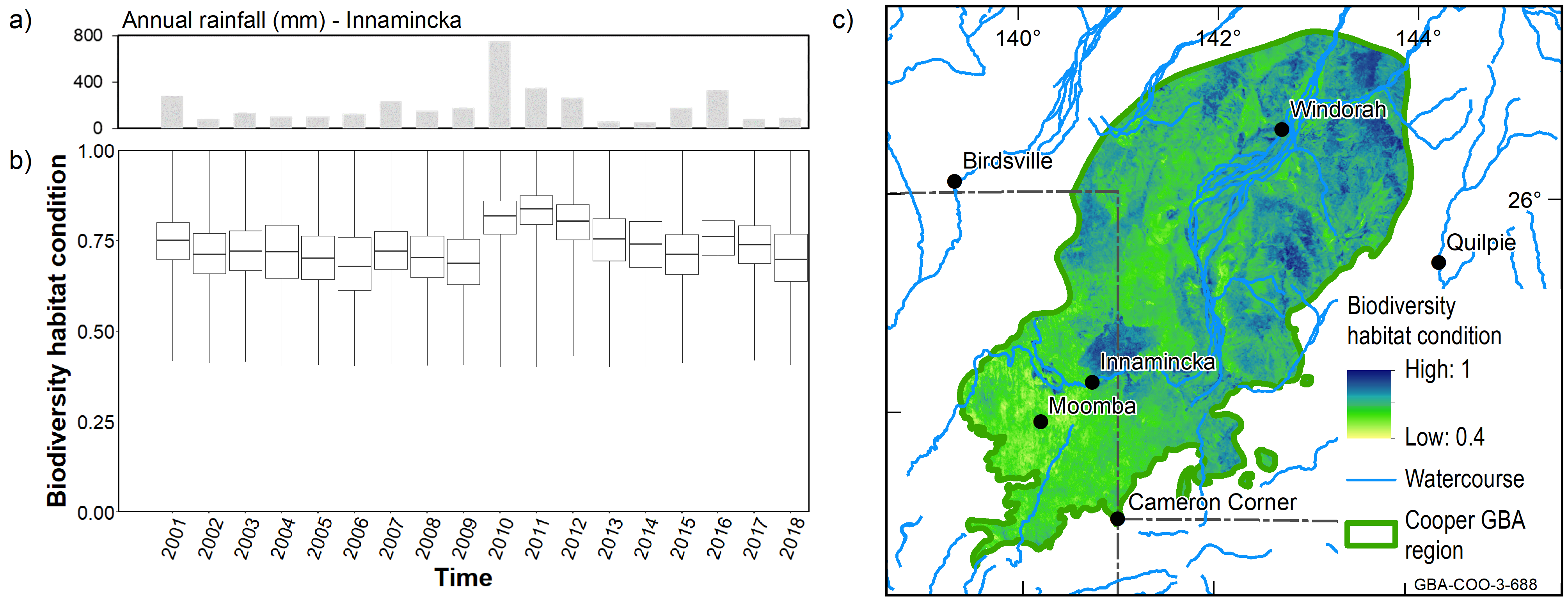
Data: Geological and Bioregional Assessment Program (2021m); Department of Environment and Science (Qld) (2018)
Element: GBA-COO-3-688
Unconventional gas resource development could amplify existing threatening processes that are impacting on biodiversity in the Cooper GBA region. This includes habitat degradation, fragmentation and loss , competition and predation by invasive species and ecosystem burning , which are of ‘potential concern’ in 25 to 30% of the Cooper GBA region. Unconventional gas resource development may also introduce threatening processes that are not currently recognised and for which there is less knowledge, such as noise and light pollution, soil compaction, and contamination of soil and water.
Habitat degradation, fragmentation and loss is a reduction in the quality, extent or connectivity of habitat, leading to increasingly isolated and smaller patches of habitat in poorer condition (Soille and Vogt, 2009; IPBES, 2019). While widely accepted as a key threatening process the capacity to develop species-specific models of vulnerability to habitat degradation, fragmentation and loss remains limited. Habitat degradation, fragmentation and loss is an inevitable consequence of expansion of the gas industry in the region, even though the physical footprint is likely to be relatively small and can be mitigated in sensitive areas.
Increased habitat degradation, fragmentation and loss, and competition and predation associated with introduced plants and predators are important drivers of the global decline in biodiversity (Woolley et al., 2019). Unconventional gas resource development activities could amplify these processes without appropriate mitigation and management. Construction of surface infrastructure to support the industry, such as roads, pipelines, well pads and camps requires removal of vegetation and the associated loss, fragmentation and degradation of habitat. Under the maximum resource development scenario, direct disturbance could increase by 27 km2, spread over up to 7,350 km2 (or 0.5 to 5.6% of the Cooper GBA region), including roads, well pads and seismic lines, as well as the areas between the disturbed areas.
The physical disturbance footprint potentially underestimates the ecological footprint of the industry in the region. The expansion of linear networks can facilitate the spread of invasive predators (for example, cats and foxes), invasive plants (for example, buffel grass) and invasive herbivores (for example, feral goats, rabbits) or other ecosystem disturbers such as pigs. The spread of invasive species may amplify competition and predation, lead to changes in fire regimes, or could degrade habitat via compositional changes in communities or soil compaction and degradation that impact on the persistence of threatened species in the region.
Furthermore, activities associated with the industry could introduce threatening processes that are not currently recognised, such as noise, light and dust pollution, as well as soil and water contamination. While there is an emerging understanding of the impacts of these threats on biodiversity (Longcore and Rich, 2004; Sordello et al., 2020), the species-specific information needed to assess these potential impacts for individual species in the Cooper GBA region is not currently available, but could be the focus of future investigations.
Habitat degradation, fragmentation and loss is recognised, based on existing EPBC Act conservation advice and recovery plans, as a key threatening process for the Australian painted snipe, the grey grasswren, plains-wanderer, kowari, dusky hopping-mouse, yellow-footed rock-wallaby and the endangered plant braided sea heath, and is a suspected threat for the remaining species in the region. Key stressors associated with habitat degradation fragmentation and loss include vegetation removal for infrastructure and the spread of invasive species, particularly those likely to lead to habitat degradation such as introduced herbivores or pigs.
Potential impacts can be mitigated by minimising the extent and location of new infrastructure, particularly roads or pipelines and by ensuring rapid and effective remediation of disturbed sites. However, there is limited knowledge to assess the efficacy of mitigation strategies for individual species, or the precise location, scale and nature of future development activities. Thus, monitoring of habitat degradation, fragmentation and loss requires continued assessment of specific developments and its intersection with important habitats and ecosystems to tailor future mitigation strategies and enable the gas industry to avoid degradation of potential habitat for protected species.
Disturbance footprints associated with the existing oil and gas industry compiled for the assessment provide a regional baseline for future comparison (Geological and Bioregional Assessment Program, 2021m). There is medium to high confidence that pathways associated with habitat degradation, fragmentation and loss could be effectively managed and mitigated by existing controls. Important knowledge gaps include a lack of species-specific information on habitat extent and condition, as well as vulnerability to degradation, fragmentation and loss and associated materiality thresholds. Remote sensing technologies provide a pathway to better support and coordinate regional-scale monitoring to improve the effectiveness and efficiency of mitigation and management by the gas industry, pastoralists and other community groups ( Box 11 ).
Box 11 Detecting changes to vegetation condition associated with gas resource development
Vegetation condition, defined as the capacity of landscapes to produce and maintain vegetation cover from available water, is estimated using satellite imagery from 2001 to 2018. Satellite-derived measures of the fraction of ground covered by live vegetation and litter provide an excellent proxy for the health of agricultural landscapes, such as the Cooper GBA region.
Vegetation condition is assessed using Compere, a relative benchmarking framework that separates management-driven impacts on ecosystem resources from the natural dynamics in those resources (Donohue et al., 2021). It works by identifying locations in a region that share similar biophysical properties to a target location and comparing it with all biophysically equivalent locations, with any differences being attributed to the effect of management activities.
Analysis of satellite monitoring vegetation cover data detected a 12 to 41% decrease in vegetation cover near gas extraction wells. Vegetation cover condition decreased within a year of establishment, started to recover after about 4 years, and had recovered to pre-development condition after 5 to 7 years.
Similarly, analysis of satellite-derived fire occurrence data ( Figure 16 ), detected rapid decreases in vegetation cover of up to 60% due to fire, with much longer recovery periods in excess of a decade. This suggests that the largest direct impact that the gas resource development is likely to have on vegetation cover condition is through changes to fire regimes.
FIGURE 16 Vegetation cover condition showing a) effect of gas well density; b) effect of fire through time; and c) spatial patterns in 2018
View a higher resolution copy of this figure
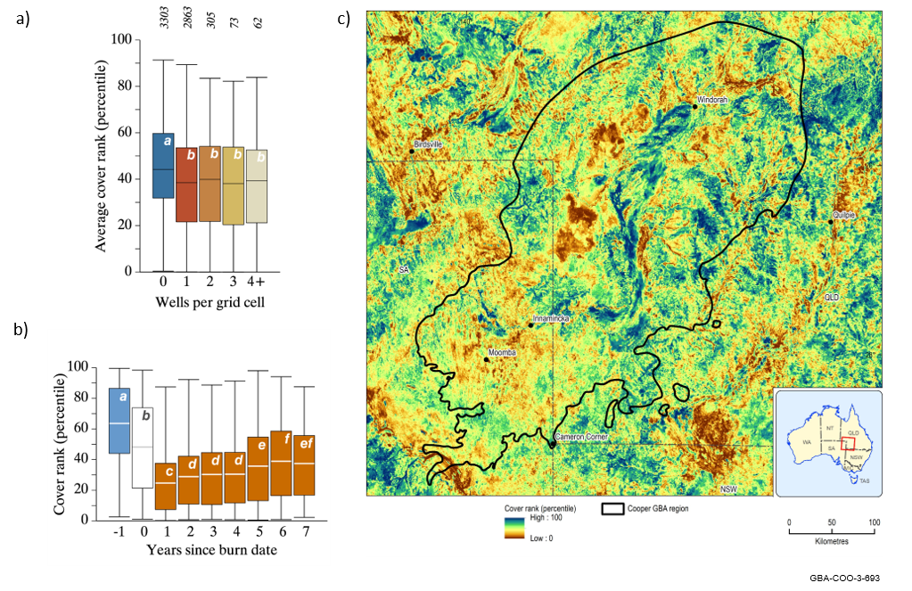
Vegetation cover condition is reported as ‘cover rank (percentile)’. Boxes show the mean (white bar) and middle 50% of values. Tails show the 1st and 99th percentiles. Letters denote significantly different means (P = 0.05) using Student’s t-test.
Source: Donohue et al. (2021)
Data: (Geological and Bioregional Assessment Program, 2021d)
Element: GBA-COO-3-693
Predation by cats and foxes is recognised as a key threatening process for 4 of the 7 protected fauna species: plains-wanderer, kowari, dusky hopping-mouse and yellow-footed rock-wallaby. While there is less evidence in the scientific literature, predation is also likely to affect the other 3 fauna species in the region: the Australian painted snipe, grey grasswren and night parrot. In addition, competition with feral herbivores for resources, such as food and shelter, is a key threatening process identified for the night parrot, dusky hopping-mouse and yellow-footed rock-wallaby.
Competition and predation are two distinct ecological processes that describe interactions between organisms. Competition occurs when resource availability is limited to such an extent that there are insufficient resources available to meet the needs of all organisms. Interspecific competition refers to competition between species and is often heightened by invasive species (Mangla et al., 2011). Predation is the process where one individual seeks to capture and consume another. Predation also includes the concept of ‘landscape of fear’ where the presence of predators increases stress in the prey leading to avoidance or physiological stress (Fardell et al., 2020). The competition and predation node description describes interactions between native and introduced species.
Competition and predation is of ‘potential concern’ for all 12 protected species. Predation by invasive predators, such as cats and foxes, is recognised as a significant contributor to biodiversity decline in Australia. Artificial watering points can create an imbalance in an ecosystem – for example increasing native species populations, attracting predators or by providing additional resources to enable introduced herbivores to establish in an area (Letnic et al., 2014) (refer to the artificial water sources node description). Increased grazing pressure associated with introduced herbivores can heighten competition for food, seed and shelter that may impact on many species in the Cooper GBA region (for example, night parrot, yellow-footed rock-wallaby). Similarly, invasive plants may colonise degraded sites and quickly displace native flora.
Unconventional gas resource development activities can contribute to the spread of invasive plants and animals when infrastructure such as roads and pipelines acts as corridors of dispersal for invasive predators and plants (Dawson et al., 2018). This allows invasive plants and animals to access areas that may have been otherwise relatively natural. Industry controls focus on the movement of plant and equipment for infrastructure development, which can hasten the movement and dispersal of important weed and pest species if not correctly carried out or without appropriate controls to prevent the spread. Once established, invasive species are difficult and costly to control and manage.
Mitigation and management of invasive species is best achieved via co-ordinated industry-wide approaches that work with existing land managers and natural resource management programs including whole-of-life-cycle planning and risk management. Dedicated invasive species officers and raising awareness of workers and contractors are key monitoring and mitigation options. There is medium to high confidence that pathways associated with competition and predation can be effectively managed and mitigated using existing controls, although understanding of the baselines and trends of the distribution and abundance of invasive species in the region is an important knowledge gap.
Changes to ecosystem burning regimes are of ‘potential concern’ in 30% of the Cooper GBA region and for all protected species in the assessment. Increased average temperatures, number of hot days (more than 35°C) and shifting rainfall patterns combine to increase risks to biodiversity associated with fire. Changes in fire regimes are identified as important threatening processes for the grey grasswren, night parrot, plains-wanderer and yellow-footed rock-wallaby. It is suspected that altered burning regimes are likely to have direct (such as mortality) and indirect (such as habitat modification) impacts on all species in the Cooper GBA region.
Fire regimes can have a major influence on the health and composition of habitat and its associated species (Catterall et al., 2007; Jansen et al., 2007). Many of the ecosystems in the Cooper GBA region are sensitive to fire. Recommended fire management for many ecosystems in the region, particularly those associated with wetland and riparian areas are to avoid or exclude fire altogether (Queensland Herbarium, 2018b). Current fire regimes are a complex interplay between vegetation structure and fuel loads, topography, traditional and contemporary fire management practices. Risks associated with extensive wildfires are generally heightened after several years of above average rainfall, largely due to the accumulation of fuels (Marsden- Smedley et al., 2012; Nano et al., 2012).
Historically, fire regimes have been influenced by lightening-induced fires, traditional and European management of landscapes (Marsden-Smedley et al., 2012). Traditional aboriginal burning practices have been displaced by fire suppression and protection of grazing pastures. However, fire is also used to encourage annual pasture monocultures, to the detriment of perennial species. Altered fire regime may be accelerated or exacerbated by the invasion of exotic pasture grasses, such as buffel grass and climate change (Marsden-Smedley et al., 2012; Silcock et al., 2013; Agnew et al., 2014). The construction of access roads and linear infrastructure within previously contiguous landscapes could increase the number and timing of deliberate or accidental sources of ignition as a result of increased human access and increase the risk of fire due to flaring during gas production (Edwards et al., 2008). However, roads can also act as fire breaks and provide access to control fires. Thus, understanding of the complex interactions between vegetation, land use, climate and fire remains poor and the ecology of fire in central Australia remains a critical knowledge gap.
Mean maximum air temperatures in the Cooper GBA region for the period 1976 to 2005 ranged from 35 to 40°C and mean minimum temperatures varied from 20 to 24°C (Geological and Bioregional Assessment Program, 2018c). The number of hot days (maximum air temperature greater than 35°C) is projected to increase from between 84 and 114 days per year for the period 1976 to 2005 by up to 80 to 90 days in the north-east of the Cooper GBA region under the 90th percentile estimate for the period 2046 to 2075 (Geological and Bioregional Assessment Program, 2018b).
Changes to ecosystem burning regimes are of ‘potential concern’ for all the protected species in the assessment. This threat is recognised in the conservation advice for some species. For other species, impacts on species persistence are likely to be driven by changes to ecosystem condition. Two pathways for changes to ecosystem burning regimes associated with unconventional gas resource development are identified. Firstly, invasive species can increase intensity and frequency of fires. For example, buffel grass is known to increase risks associated with fire as it is a highly flammable fuel that can carry high-intensity fires (Marshall et al., 2012). Secondly, increased access throughout the region and associated traffic can increase the risk of accidental or deliberate ignition (Edwards et al., 2008).
Mitigation and management of ecosystem burning regimes is best achieved via a coordinated regional-scale approach. Localised management options include development of fire management plans that include restricting access to industry roads and tracks by non-industry personnel or during periods of high fire danger and effective control of the invasive weeds.
Key knowledge gaps identified in the assessment relate to a lack of understanding of responses to fire by individual species. Some species such as the grey grasswren or the night parrot require habitats that are relatively free of fire for long periods. However, relationships between species persistence and fire for many species are unclear. There is medium to high confidence that pathways associated with ecosystem burning could be effectively managed and mitigated using existing controls.
Reduced floodplain inundation is of ‘potential concern’ for 2 endangered bird species: the Australian painted snipe and the grey grasswren. It is not identified as a direct threat in existing EPBC Act conservation advice and recovery plans or as a key threatening process for other protected fauna and flora endpoints. Unconventional gas resource development activities could reduce floodplain inundation, which is of ‘potential concern’ in 1,613 km2 , or 6.4% of floodplain habitat that support these species. Where knowledge of plant biology and water requirements is limited, the precautionary principle is applied, and changes to floodplain inundation are assessed as of ‘potential concern’ for braided sea heath, Indigofera oxyrachis and Xerothamnella parvifolia.
Floodplain inundation occurs when very heavy local rainfall exceeds the infiltration capacity of the floodplain, or under high flow conditions when water spills from the river (overbank flows) and spreads over the floodplain, or a combination of the two (refer to the floodplain inundation node description). The variability, timing and extent of floods play a major role in sustaining the biodiversity of floodplain environments (Leigh et al., 2010). Vegetation spatial patterns reflect the soil and flood characteristics experienced in an area. Alternating dry and wet phases are especially important for nutrient cycling and system productivity (Jaensch, 2009).
The persistence of the Australian painted snipe and the persistence of the grey grasswren are tied to water regimes required to sustain their habitat. This is true for all floodplain-dependent biota. The Australian painted snipe requires shallow permanent or ephemeral wetlands; changes to water regimes of these habitats is identified as the most critical threat to this species (Commonwealth of Australia, 2019). Similarly, the grey grasswren depends on dense lignum swamps, which form their primary habitat. Thus, changes to floodplain inundation are closely linked with habitat, degradation, fragmentation and loss for these species.
Given the low relief of the Cooper Creek floodplain, any changes to overland flows associated with civil construction could impact on sensitive areas (Wakelin-King, 2013). Legislation prohibits unconventional gas resource development activities, including linear infrastructure, in sensitive areas. Mitigation strategies to avoid or minimise overland flow obstructions are documented in relevant environmental impact plans (Santos, 2015; Senex Energy, 2016; Beach Energy, 2019) (refer to the civil construction and overland flow obstruction node descriptions).
Key knowledge gaps relate to understanding of the distribution and abundance of the Australian painted snipe and the grey grasswren in the Cooper GBA region and the water regimes required to support critical habitat for the individual species. There is medium to high confidence that impacts associated with changes to floodplain inundation can be managed or mitigated. Baseline data collected by the GBA Program to address knowledge gaps and improve future management of the Cooper Creek floodplain include aerial LiDAR surveys, 2D flood inundation model, and satellite monitoring of floodplain vegetation water use, historical flooding, biodiversity persistence and vegetation condition (refer to Box 7 , Box 8 , Box 10 , Box 11 ).
Soil and surface water contamination are conservatively assessed as of ‘potential concern’ for all fauna-related endpoints. The assessment of potential impacts on native fauna due to soil and surface water contamination considers population size, habitat extent, proximity to water, water requirements and species mobility. The precautionary principle is applied as there is insufficient species-specific information to establish robust materiality thresholds for the toxicity of potential pollutants on the 7 protected fauna species.
Soil and surface water contamination leading to pollution occurs when the concentration of a biological, chemical or physical property is sufficient to cause an adverse effect (refer to the soil contamination and surface water contamination node descriptions). What constitutes acceptable change depends on the ecosystem services the soil or surface water provides and may be informed by regulatory requirements, guidelines and approvals.
The current data and knowledge base are insufficient to establish robust materiality thresholds for a decrease in persistence of native fauna due to an increase in surface water contamination (refer to the surface water contamination node description). In the absence of a robust materiality threshold, the link is evaluated as of ‘potential concern’ in line with the precautionary principle.
Surface water and soil contamination are associated with spills and leaks to the environment that could impact on the fitness of species exposed to the contaminants (refer to the accidental release node description). Soil contamination is not recognised as a direct threat for any of the species in the assessment, and its impact through habitat degradation, fragmentation and loss is not material. In the case of spills and leaks, exposure to surface water contamination through physical exposure, direct consumption, or consumption of plants, insects, and sediment-dwelling or aquatic worms, crustaceans and invertebrates, could impact on populations of the Australian painted snipe, grey grasswren, night parrot and yellow-footed rock-wallaby (refer to the surface water contamination node description). The potential for chemicals to partition and accumulate in sediments indicates that sediment feeders have a higher potential concern. Although there is no direct evidence that the kowari or the dusky hopping-mouse are dependent on surface water to meet their water requirements, their greater population density in areas close to water sources (possibly associated with food sources) means that potential impact cannot be discounted.
Compliance reporting shows existing regulations, approval conditions and industry practices are effective in preventing, or ensuring quick remediation of, spills and leaks. There is high confidence that impacts associated with surface water and soil contamination can be mitigated through existing controls and regulations, despite knowledge gaps associated with species specific thresholds of exposure and toxicity.
Noise and light pollution can have significant impacts on all animal taxa. Due to considerable uncertainty and use of the precautionary principle, noise and light pollution is assessed as of ‘potential concern’ in 25% of the Cooper GBA region. Noise and light pollution may be of particular concern to cryptic (for example, the Australian painted snipe) or nocturnal species (for example, the night parrot, kowari, dusky hopping-mouse). Noise pollution and light pollution are not currently recognised as key threatening processes under the Australian Government and state legislation.
Ecological light pollution is any artificial light that alters the natural patterns of light and dark in ecosystems that can affect the physiology, behaviour and reproduction of a range of animal taxa through changes in vision, foraging and reproductive behaviours, as well as reduced reproductive success (Newport et al., 2014; Longcore and Rich, 2004). Night-time light pollution from gas fields includes light emitted from gas flares, vehicle headlights and lighting required to operate safely during drilling and hydraulic fracturing operations (Jones et al., 2015) (refer to the light pollution node description). The draft national light pollution guidelines recommend further assessment if a light source is within 20 km of important habitat for a listed species (Commonwealth of Australia, 2020).
Noise pollution is any human-made sound that alters the behaviour of animals or interferes with their functioning (Newport et al., 2014; Barber et al., 2010) (refer to the noise pollution node description). Noise pollution is also known as ‘masking’ and includes any anthropogenic noise that alters reproduction, communication between individuals (courtship, begging, distress and alarm calls), survivorship, reproduction, habitat use, distribution, abundance or genetic composition (Newport et al., 2014; Barber et al., 2010; Sordello et al., 2020). Similarly, noise pollution can impact on the capacity of nocturnal species to forage, interfere with circadian rhythms, or change patterns of habitat use and occupancy for a range of species (Gaston et al., 2012).
Noise and light pollution can have a significant impact on all animal taxa (Kunc and Schmidt, 2019) and is of ‘potential concern’ in 25% of the Cooper GBA region. While there is considerable uncertainty associated with the impacts of noise and light pollution on fauna species (Newport et al., 2014), a number of species are nocturnal (for example, kowari, night parrot) or cryptic (for example, Australian painted snipe, grey grasswren, night parrot) and may be susceptible to increased noise and light pollution. Where knowledge of animal physiology and behaviour is limited, the precautionary principle is applied, and changes to noise and light pollution are assessed as of ‘potential concern’ for all fauna species. Confidence in existing controls is low to medium, as noise and light management plans in the Cooper GBA region primarily address worker health and safety and do not necessarily address potential impacts on wildlife (refer to the operation of industrial machinery and vehicle movement node descriptions).
FIND MORE INFORMATION
Impact assessment summary for the Cooper GBA region
Causal network dataset (Geological and Bioregional Assessment Program, 2021c)
Fact sheets are available on the Geological and Bioregional Assessment website .
- Fact sheet 14: Gas extraction and vegetation condition (Geological and Bioregional Assessment Program, 2021b)
- Fact sheet 27: Modelling persistence of biodiversity at a regional scale (Geological and Bioregional Assessment Program, 2021h)