Hunter assessment at a glance

This bioregional assessment considered the potential cumulative impacts on water and water-dependent assets due to 22 additional coal resource developments in the Hunter subregion in NSW (Figure 1). The assessment is a regional overview of potential impacts on, and risks to, water-dependent ecological, economic and sociocultural assets, identifying where potential changes in water resources and ecosystems may occur, and ruling out areas where impacts are very unlikely. Governments, industry and the community can then focus on the areas that are potentially impacted and apply local-scale modelling when making regulatory, water management and planning decisions.
Headline finding: Regional-scale modelling indicates potential risks to Wyong River, Loders Creek, Saddlers Creek and Wollars Creek. Using more detailed local information significantly reduced modelled risk to the Wyong River. Other streams were not modelled using local data.
Groundwater: An area of 1879 km2 potentially experiences cumulative groundwater impacts due to baseline and additional coal resource developments. See Groundwater
Surface water: Regional-scale modelling indicates potentially large changes in flow regime in Wyong River, Loders Creek, Saddlers Creek and Wollars Creek. See Surface water
Ecosystem impacts: The zone of potential hydrological change includes 102 km2 of groundwater-dependent ecosystems – predominantly rainforests, forested wetlands, and wet and dry sclerophyll forests. See What are the potential impacts of additional coal resource development on ecosystems?
Asset impacts: Reductions in water availability in the Hunter River at Greta are very likely to exceed 5 GL per year, but are very unlikely to exceed 12 GL per year, over the period from 2013 to 2042. See What are the potential impacts of additional coal resource development on water-dependent assets?
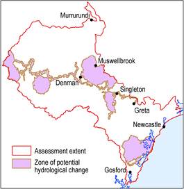
Figure 1 The zone of potential hydrological change
The pink zone (defined further in Box 4) was developed to show where efforts to identify potential impacts should be focused. Impacts are ruled out in areas outside this zone, which combines (i) the area with at least a 5% chance of exceeding 0.2 m drawdown due to additional coal resource development, and (ii) the area with at least a 5% chance of exceeding changes in specified surface water characteristics that arise due to additional coal resource development.
Data: Bioregional Assessment Programme (Dataset 1)
