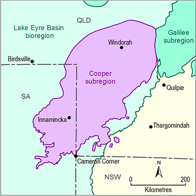
Summary
The Cooper subregion is located across the SA–Queensland border. The subregion also covers a small part of NSW at Cameron Corner. The subregion spans an area of about 130,000 km2 and is characterised by the braided channels of Cooper Creek and the Barcoo River. Most of the subregion is located within the Cooper Creek – Bulloo river basin. A small part of the north-west of the subregion is within the Diamantina–Georgina river basin.
The five main physiographic regions in the Cooper subregion are the Strzelecki Desert Plains, Innamincka Plains, Sturt Desert Plains and Cooper Plain, and the Eromanga Lowlands. Cooper subregion soils generally have low agricultural potential (Tenosols, Sodosols, Kandosols and Rudosols); areas of Vertosols mainly located within the Cooper and Innamincka plains have higher agricultural potential.
The Cooper subregion is sparsely populated with just 1032 residents and 626 dwellings recorded in mesh blocks which intersect the subregion in the 2011 census. The main localities in the subregion are Canterbury in Queensland, Innamincka and Moomba in SA and Cameron Corner on the border of NSW, Queensland and SA. The subregion covers parts of Diamantina Shire, Barcoo Shire, Longreach Regional, Quilpie Shire, Bulloo Shire and Outback Areas Community Development Trust local government areas (LGAs). The top industries of employment for these LGAs are mining, manufacturing, and agriculture, forestry and fishing.
The main land use class in the subregion is rangelands grazing. There is also an area of mining and intensive gas treatment, storage and distribution at Moomba, south-west of Innamincka. The subregion contains seven protected areas listed in the Collaborative Australian Protected Areas Database and eight wetlands listed in A directory of important wetlands in Australia (DIWA; Department of the Environment, Dataset 6). Several springs from the Lake Frome Supergroup supporting threatened ecological communities of native species dependent on the natural discharge of groundwater from the Great Artesian Basin occur just outside the Cooper subregion on the edge of Lake Blanche and further south near Lake Callabonna. These communities are listed as endangered under the Commonwealth’s Environmental Protection and Biodiversity Conservation Act 1999. The Coongie Lakes and Lake Pinaroo (Fort Grey Basin) Ramsar wetlands also occur partly within the subregion.
The Cooper subregion lies within the Eyre region for Indigenous language groups and covers the Birria, Wangkumara, Yandruwandha, Yawarawarka and Karuwali tribal or language groups. There are 14 Indigenous Land Use Agreements in place within the Cooper subregion.
The climate is generally hot and dry with annual rainfall ranges from less than 200 mm to more than 300 mm and mean maximum temperatures above 20 °C year round. Rainfall is summer dominated and potential evapotranspiration exceeds rainfall in all months. Climate change projections suggest slightly higher warming for the Cooper subregion than the continental average, with a range of 1.1 to 1.2 °C by 2030 and up to 3 to 4 °C by 2070 under a high greenhouse gas emissions scenario. Projected changes in rainfall have more uncertainty but a slight decline of 1 to 2.5% is projected by 2030 and this increases to 5 to 20% by 2070 under a high-emissions scenario. Most of these rainfall declines are projected to occur in winter and spring.

