Impact assessment for the Beetaloo GBA region - Geological and Bioregional Assessment: Stage 3
The Geological and Bioregional Assessment (GBA) Program’s findings are available in a range of formats suited to a variety of audiences and levels of expertise. On this page, you will find the Program’s stage 3 results and can access the publications.
The full results from Stage 3 of the GBA Program are presented through the GBA Explorer. The GBA Explorer is an interactive visualisation that allows users to view the causal network impact assessment as background information and evaluations. For more information watch the video or read the ‘how to’ information available on the GBA Explorer site.
The Beetaloo GBA region results are also synthesised into a shorter report, that highlights the key findings of the GBA Program’s impact assessment. Click the 'Start reading the report' button at the bottom of this page to read the report chapter by chapter.
The report is separated into 7 chapters:
- About the assessment – The geological and bioregional assessment for the Beetaloo GBA region considered potential regional-scale impacts from future development of unconventional gas resources on water and the environment. It aims to provide regulators and industry with a common information base to inform decision-making and enable the coordinated management of regional-scale impacts.
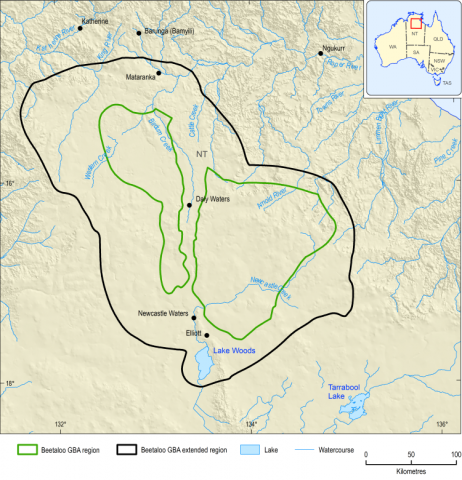
- About the region - The Beetaloo GBA region and the broader Beetaloo GBA extended region support important landscapes and habitats that have cultural, economic, environmental and social benefits.
- Causal network for the Beetaloo GBA region - The causal network illustrates the complex and interconnected nature of the natural environment and unconventional gas resource development activities in the Beetaloo GBA region. It is used to evaluate how these activities could cause potential impacts to water and the environment.
- Assessment results –Results are presented for potential impacts on:
- Surface water - Where activities are conducted in the vicinity of waterways, a small number of pathways have potential for impact. There is high confidence that existing mitigation strategies will avert these impacts
- Groundwater - Groundwater is the most probable source of water for unconventional gas resource development. The assessment has found that aquifers in the region, such as the Cambrian Limestone Aquifer, can supply this water without adverse regional impacts.
- Environment – Invasive plants and broadscale landscape changes due to vegetation removal and vehicle movement have the strongest influence on threatened species and protected areas in the Beetaloo GBA region. There is high confidence that existing management controls can avoid and mitigate these potential impacts.
- Protected fauna and flora - The assessment prioritised six protected animals based on the importance of the Beetaloo GBA region to each species. Potential impacts involve activities at the surface leading to increased invasive plants and animals, and vegetation removal. There is high confidence that existing management controls can avoid and mitigate these impacts.
- Additional studies - The GBA Program was allocated additional funding in the 2019-20 federal budget for five additional activities to support the delivery of the Beetaloo GBA region assessment and the Northern Territory’s Strategic Regional Environmental and Baseline Assessment.
- Monitoring - The causal network identifies activities, stressors and processes from unconventional gas resource development that may lead to changes in endpoints related to water and the environment. Monitoring is critical for evaluating changes in a system with known impacts. The causal network identifies points along a pathway where monitoring would be most useful.
- Conclusion – Key findings – There is high confidence that all potential impacts identified in this assessment due to unconventional gas resource development can be effectively mitigated through ongoing compliance with existing regulatory and management controls.
The ‘Impact assessment- for the Beetaloo GBA region - Geological and Bioregional Assessment: Stage 3 synthesis’ is available via the product download to the left.
The GBA Program used causal networks to assess potential impacts on water and the environment. The causal network provides a systematic approach to assessing direct and indirect pathways from unconventional gas development activities to environmental values. It can be consistently applied across large areas and diverse environments. Causal networks also allow the evaluation of likelihood, consequence and the effectiveness of mitigation or management measures.
For more information on the causal network assessment methodology used by the GBA Program, please see the Introduction to causal networks.
Further information is available through the GBA Explorer, the Program’s interactive online assessment tool. A summary of the Program’s findings is also available through the interactive viewer.
Beetaloo additional studies
The GBA Program was extended to include additional research to support the delivery of the Beetaloo GBA region assessment and the Northern Territory’s Strategic Regional Environmental and Baseline Assessment. The supporting activities were:
- Baseline Ecological surveys to improve understanding of terrestrial and aquatic ecosystems in the region. These surveys also targeted threatened species providing new records and improved understanding of habitat of the Gouldian finch, crested shrike-tit (northern) and greater bilby. The occurrence of the Gulf snapping turtle in the region was also established during these surveys.
- Water characterisation and discharge studies from the Cambrian Limestone Aquifer. This work investigated the relative significance of different hydrogeological processes that contribute to water flows in the Cambrian Limestone Aquifer and at Mataranka Thermal Pools through tracer studies.
- Remote sensing studies including terrestrial and spaceborne Light Detection and Ranging (LiDAR) to record baseline conditions and monitor changes in habitat condition over time.
- Seismic monitoring studies in the Beetaloo Sub-Basin undertaken by Geoscience Australia, to install a seismic monitoring network. This network commences work to create a more defined baseline of seismic activity in the Beetaloo Sub-basin. The program aims to detect and locate natural seismic activity (such as earthquakes) in the area, as well as monitoring for any human-induced seismicity that could potentially result from unconventional gas activities.
- Development of a data management platform for the Northern Territory Government to support the Strategic Regional Environmental and Baseline Assessment data.
The results, products and factsheets completed through these additional studies, where applicable, are available for download through the ‘supporting materials’ tab under ‘Geological and Bioregional Assessment Program’. All data is also available for download at data.gov.au.