3.1 Overview
The design choices outlined in Section 2.3 respect the objectives and chain of causation described in Section 2.1 and constraints in Section 2.2, and results in a number of design elements in the impact and risk submethodology. These individual design elements are summarised in Figure 7, which presents the high-level logic and workflow that culminates in the impact and risk analysis.
Given the most likely coal resource development in a region, a systematic hazard analysis provides a basis for describing the nature and severity of potential risks by identifying the potential causal pathways that may lead to changes in surface water and groundwater. Coupled with the conceptual understanding of the regional geology and hydrogeology, these pathways are embedded in regional hydrological models that make predictions at specific locations. Uncertainty is propagated through hydrological models by basing predictions upon plausible distributions of model parameters rather than fixed values. The large number and diversity of ecological assets is addressed by classifying ecosystems into landscape classes that, while still subject to some uncertainty, are expected to respond similarly to changes in groundwater and/or surface water.
For those landscape classes that may experience hydrological change, qualitative mathematical modelling is used to produce SDGs that summarise the key interactions between ecosystem components and their dependence on hydrology. The qualitative mathematical modelling process captures direct and indirect effects that may occur following changes to the hydrology as a result of coal resource development. Qualitative mathematical modelling also underpins the choice of important hydrological response variable predictions, to come from the hydrological models, and the receptor impact variables that are to be used as ecosystem indicators for that landscape class.
Receptor impact models for a landscape class are functions that translate potential change in hydrological response variables into predicted changes in a receptor impact variable (as an indicator of ecosystem condition). They are constructed on the basis of a carefully structured expert elicitation and incorporate both uncertainty in the input hydrology and uncertainty in the functional relationship as characterised by the elicited responses from experts.
Predicted distributions of the maximum hydrological change at particular locations across the simulation period (2013 to 2102), for hydrological response variables at particular locations in the short term (2013 to 2042) and long term (2073 to 2102), and for receptor impact variables at particular locations at the end of the short term (2042) and at the end of the long term (2102), underpin the assessment of impact and risk. Predictions at specific locations may be summarised and aggregated for assessing impacts and risks for landscape classes or individual water-dependent assets. The predicted distributions are a result of the probabilistic treatment of uncertainty through a modelling chain that considers the receptor impact modelling as conditionally independent given the hydrological response variables, underpinning the quantitative assessment of impact and risk.
Narratives, based on logic and knowledge, to describe possible impacts and implications of developments may also be important. The ecological impacts box within the impact analysis in Figure 7 emphasises this for some landscape classes that have qualitative models and receptor impact modelling, some that only have qualitative models, and others that are restricted to other conceptual models and existing literature. There is a synergy between all these parts. A good analysis will use all of these devices in concert to develop a compelling BA.
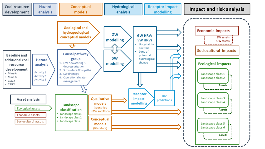
GW = groundwater; HRV = hydrological response variable; SW = surface water; RIV = receptor impact variable
While not necessarily evident in Figure 7 there is a strong focus on progressively ruling out potential impacts, where possible, both spatially and in terms of specific groundwater or surface water effects, so as to concentrate the attention of the assessment where potential impacts have a greater probability of occurring. This process starts with the application of a hazard analysis to guide choices encountered during the analysis. Where impacts are likely to be small in a particular circumstance, then scarce resources are better allocated elsewhere in the analysis. For instance, landscape classes are only considered in the impact and risk analysis where there are potential hydrological changes attributable to additional coal resource development.
3.2 Description of workflow leading to assessment of impact and risks
This section provides further details on the components depicted in Figure 7 that lead to the impact and risk analysis.
3.2.1 Coal resource development
The coal resource development pathway (CRDP) is considered the most likely future, based on the analysis and expert judgment of the Assessment team in consultation with state regulators and industry at a particular point in time. The creation of the CRDP is described in detail in companion submethodology M04 (as listed in Table 1) for developing a coal resource development pathway (Lewis, 2014). Product 1.2 (coal and coal seam gas resource assessment) assesses the current, historical and potential future coal resource development in a bioregion or subregion. The CRDP used as the basis of the assessment is documented in product 2.3 (conceptual modelling).
The CRDP may ultimately be implemented in different ways (e.g. changes to timing) or the list of developments may even change (e.g. a proponent may withdraw for some reason). This reflects the dynamic nature of resource investment decision making, which may ultimately be impacted by diverse economic, political or social factors. Consequently, the CRDP needs to be viewed as an indicative scenario that provides value in highlighting potential changes for water resources and water-dependent assets that may need to be considered further in local analyses or conditions. Equally as important, the CRDP plays an important role in identifying where changes will not occur and thus flagging where potential impacts to water resources and water-dependent assets are very unlikely. As part of the indicative nature of the two futures considered in BA (baseline and CRDP), it is important to recognise that factors such as climate change or land use are held constant between the two futures.
3.2.2 Hazard analysis and causal pathways
The dedicated hazard analysis is a systematic and structured process to identify potential risks to water-dependent assets by considering the activities that occur as part of coal resource development in a region and the potential chain of effects that they may cause that could impact water resources and water-dependent assets.
The hazard analysis methodology used in bioregional assessments (BAs) is described in the companion submethodology M11 (as listed in Table 1) for analysing impacts and risks (Ford et al., 2016). In brief, the hazards arising from coal resource development are assessed using Impact Modes and Effects Analysis (IMEA). The hazards are firstly identified for all the activities (impact causes) and components in each of the five life-cycle stages. For coal seam gas (CSG) operations the stages are: (i) exploration and appraisal, (ii) construction, (iii) production, (iv) work-over, and (v) decommissioning. For coal mines the stages are: (i) exploration and appraisal, (ii) development, (iii) production, (iv) closure, and (v) rehabilitation. The hazards are scored on the basis of the perceived severity of the potential impact, the perceived likelihood of the hazard occurring and the detectability of the hazard under current industry standards and regulatory regimes.
The hazard analysis reflects the conceptual models and beliefs that domain experts hold about the ways in which coal resource development might impact surface water and groundwater, and the relative importance of these potential impacts. As a result, the analysis enables these beliefs and conceptual models to be made transparent.
The hazard analysis provides a comprehensive list of hazards. Only water-mediated impacts, and specifically those related to water quantity, groundwater level or water resource availability are in scope for BA. Potential water quality impacts considered are limited to salinity and are only addressed qualitatively, though the process of the assessment identifies other water quality attributes that may be affected by activities that occur as part of the coal resource development.
BAs are also primarily concerned with those surface water and groundwater hydrological effects that may accumulate, either over extended time frames or as a result of multiple coal resource developments. These typically correspond to changes in surface water and groundwater that are sustained over long periods of time, sometimes decadal, and which may create the potential for flow-on effects through the wider hydrological system. Many activities related to coal resource development may cause only local or on-site changes to surface water or groundwater. These are not considered in BAs because they are assumed to be adequately managed by site-based risk management and mitigation procedures, and are unlikely to create potential cumulative impacts.
There is considerable structure and hierarchy within these lists of hazards, and it is reasonable to aggregate or consider hazards with the same causal pathway together even if they occur because of different activities or at different life-cycle stages or at different time scales. These aggregated causal pathways are generic and have substantial commonality between bioregions and subregions. Four causal pathway groups are specified to be used consistently in BAs:
- ‘Subsurface depressurisation and dewatering’
- ‘Subsurface physical flow paths’
- ‘Surface water drainage’
- ‘Operational water management’.
For more detail about these causal pathway groups, as well as the causal pathways within them, refer to companion submethodology M05 (as listed in Table 1) for development of a conceptual model of causal pathways (Henderson et al., 2016).
Conceptual models of causal pathways are developed to characterise the causal pathways, the logical chain of events ‒ either planned or unplanned ‒ that link coal resource development and potential impacts on water resources and water-dependent assets. The conceptual models of causal pathways bring together a number of other conceptual models developed in a BA, for both the baseline and the CRDP. The landscape classes and the hazard analysis are also important inputs to the process. Emphasising gaps and uncertainties is as important as summarising what is known about how various systems work.
The causal pathways play a critical role in focusing a BA on the coal resource development impacts and their spatial and temporal context. They provide a basis for ruling out potential impacts for some combinations of location and assets; for example, a particular type of wetland might be beyond the reach of any type of potential impact given the activities and location of the specific coal resource development in the bioregion or subregion. The causal pathways also underpin the construction of surface water and groundwater models, and frame how the model results are used to determine the severity and likelihood of impacts on water and water-dependent assets.
3.2.3 Conceptual modelling
The conceptual models of the geology and hydrogeology of a bioregion or subregion are critical to the analysis. This ensures that the assessment considers all reasonable possibilities about the geological composition and architecture, and the hydrological components and processes that may occur, even if only the most plausible case is implemented in the hydrological modelling and uncertainty analysis.
The geology and hydrogeology of a bioregion or subregion is complex. The representation in the conceptual model needs to trade-off including detail that may have no material effect on the outcomes with oversimplification that will not survive critical scrutiny. The key guide to choosing an elaboration is to consider its plausibility and potential impact on the final results. Models that are implausible or those that will not materially change the final analysis should not be pursued.
Conceptual modelling of geology and hydrogeology is typically described in product 2.1-2.2 (observation analysis, statistical analysis and interpolation) (where any geological models constructed are described), product 2.3 (conceptual model of causal pathways) and product 2.6.2 (groundwater numerical modelling). The companion submethodologies M05 for developing a conceptual model of causal pathways (Henderson et al., 2016) and M06 for surface water modelling (Viney, 2016) and M07 for groundwater modelling (Crosbie et al., 2016) (as listed in Table 1) also contain important additional detail.
Conceptual models also need to be developed for landscape classes that are potentially impacted. These conceptual models serve a number of purposes in the analysis. They are a communication tool that represents understanding of the systems to assist the Assessment team to discuss potential impacts to the bioregion or subregion. They are also the basis for justifying choices about particular response and impact variables. There are a variety of methods for constructing conceptual models (described in detail in companion submethodology M05 (Henderson et al., 2016), some of which have already been extensively used to describe the potential impacts of CSG extraction and coal mining. All of these techniques are permissible in the initial stages of the conceptual modelling process, but the impact and risk analysis methodology requires that conceptual models are eventually translated into SDGs (Puccia and Levins, 1985) of landscape classes. These allow the Assessment team to develop qualitative mathematical predictions and assess possible direct and indirect ecological impacts.
The construction of qualitative mathematical models for landscape classes and their specific role in receptor impact modelling is described in detail in companion submethodology M08 (as listed in Table 1) for receptor impact modelling (Hosack et al., 2018a).
3.2.4 Hydrological analysis and uncertainty analysis
Surface water models and groundwater models are developed and implemented in order to represent and quantify the hydrological systems and their likely changes in response to coal resource development (both baseline and CRDP). Models are developed within the context of the coal resource development, the potential hazards and causal pathways, and the conceptual understanding of the regional hydrology, geology and hydrogeology.
Surface water models are drawn from the Australian Water Resources Assessment (AWRA) modelling suite, which includes the landscape model, AWRA-L, for streamflow prediction and river systems model, AWRA-R, for river routing and management. The rationale for this choice among alternative surface water hydrological models is described in companion submethodology M06 (as listed in Table 1) for surface water modelling (Viney, 2016). The river systems model is only used in a subset of bioregions or subregions and depends on the nature of the river regulation and the availability of existing streamflow data. The groundwater modelling is regional, and the choice of model type and coding is specific to a bioregion or subregion depending on data availability and the characteristics of the coal resource development in the area. For more details, refer to companion submethodology M07 (as listed in Table 1) on groundwater modelling (Crosbie et al., 2016).
The hydrological models numerically estimate values for the hydrological response variables, which are further analysed and transformed for the impact analysis. The hydrological response variables are subjected to sensitivity analysis and uncertainty analysis, which test the degree to which each of the model inputs (parameters) affects the model results. It does this by running the model thousands of times and randomly varying the input parameters within a precisely defined set of plausible ranges. The most influential parameters identified are taken into an uncertainty analysis, where more carefully chosen prior distributions for those parameters are propagated through to model outputs.
The potential hydrological changes under the coal resource development futures (baseline and CRDP) are summarised through a set of surface water and groundwater hydrological response variables. Many of these focus on maximum possible change between the baseline and CRDP across the 90-year simulation window (e.g. maximum additional groundwater drawdown). Given the focused uncertainty analyses, these are summarised at computational or model nodes in the surface water and groundwater modelling (products 2.6.1 and 2.6.2) in Component 2. For the impact analysis and reporting, the hydrological response variables are interpolated to the extent of the model domains for surface water and groundwater models.
The hydrological changes may be summarised by one or more zones of potential hydrological change. These are described in detail in Section 4.1.1 and consider the thresholds and probabilities across multiple hydrological response variables and define a zone that is useful for reporting against. One important role of the zone of potential hydrological change is to identify landscape classes that need to be investigated further through qualitative modelling and receptor impact modelling. Landscape classes or assets that lie outside of the zone of potential hydrological change are very unlikely to experience any hydrological change due to additional coal resource development.
Not all hydrological changes are able to be modelled numerically for reasons that include scale, lack of existing data and model complexity. In some cases hydrological changes may be specified conceptually or based on scientific logic, for example, salinity impacts upstream of a coal mine may not be able to be modelled but may be ruled out of consideration given the known causal pathways and the implausibility of that change occurring.
There is a central focus on characterising the range or distribution of potential outcomes hydrologically (i.e. the surface water or groundwater hydrological effects) by considering the uncertainty as fully as possible in all predictions. For example, groundwater models are run many thousands of times using a wide range of plausible input parameters for many of the critical hydraulic properties, such as the hydraulic conductivity and storage coefficients of all modelled hydrogeological layers. This differs from the traditional deterministic approach used more routinely for surface water and groundwater modelling and is driven by the need for a quantitative representation of the predictive uncertainty through probability distributions that allow BA to consider the likelihood of impacts or effects of a specified magnitude.
The dedicated uncertainty analysis undertaken for the hydrological models within BAs is described in detail in companion submethodology M09 (as listed in Table 1) for propagating uncertainty through models (Peeters et al., 2016). Full details of the numerical modelling for surface water and groundwater are covered in companion submethodology M06 (Viney, 2016) and companion submethodology M07 (Crosbie et al., 2016), respectively.
3.2.5 Receptor impact models
Receptor impact models are statistical functions that translate the modelled hydrological changes into the distribution of potential ecosystem outcomes that may arise from those changes. Within BAs, hydrological changes are described by hydrological response variables, ecosystem outcomes are described by receptor impact variables, and a receptor impact model determines the relationship between a particular receptor impact variable and one or more hydrological response variables. For instance, the projected foliage or percent canopy cover might be selected as a receptor impact variable for assessing the condition of riparian or floodplain vegetation communities, and that may be considered to depend on the number of overbank flow events, the number of overbench flow events and the depth to groundwater.
Receptor impact models are relevant to specific landscape classes, and play an essential role in quantifying potential impacts for water-dependent assets that may have ecological or sociocultural value. In the ecological scientific literature, receptor impact models are often known as ‘ecological response functions’ (Arthington et al., 2010; Overton et al., 2009; Poff and Zimmerman, 2010).
Receptor impact models could be based on empirical data if it existed. In practice the empirical information is usually incomplete so structured elicitation of experts’ beliefs is used to integrate expert knowledge into the receptor impact models.
Where available, receptor impact modelling makes a valuable contribution to the impact and risk analysis in a BA. The modelling encapsulates understanding about the impacts of changes in hydrology over the assessment period on potential affected ecosystems and water-dependent assets. It is a key step of the impact and risk analysis as it converts the potentially abstract information about hydrological changes to quantities that stakeholders care about and can more readily understand and interpret. In particular, outcomes of the modelling will relate more closely to their values and beliefs and therefore support community discussion and decision making about acceptable levels of development.
Receptor impact models are relevant to specific landscape classes. They describe the range of possible changes in a receptor impact variable across a landscape class that might be observed for a given hydrological change (i.e. changes to the hydrological response variables). The range of possible changes reflects the experts’ uncertainty about the response of the receptor impact variables to a given hydrological change, and the experts’ beliefs about the heterogeneity within a landscape class and the variability in response that this creates. The estimated receptor impact variable is thus not the predicted response at a particular assessment unit but rather the predicted response across the landscape class for that hydrological change.
Within BAs examples of receptor impact variables include the projected foliage cover, the abundance of macroinvertebrate families, the presence of tadpoles, mean hyporheic taxa richness, the abundance of riffle breeding frogs, the abundance of hydropsychidae larvae or catfish abundance within a specific spatial frame. Predictions of receptor impact variables become an important line of evidence in assessing potential ecosystem or asset impacts, but should be considered in conjunction with the qualitative mathematical models, broader hydrological changes, local information and other information sources (e.g. data from remote sensing).
Receptor impact modelling and the process for creating receptor impact models is described in detail in companion submethodology M08 (as listed in Table 1) (Hosack et al., 2018a). This includes a dedicated tabulation of their assumptions, and the implications of those assumptions.
