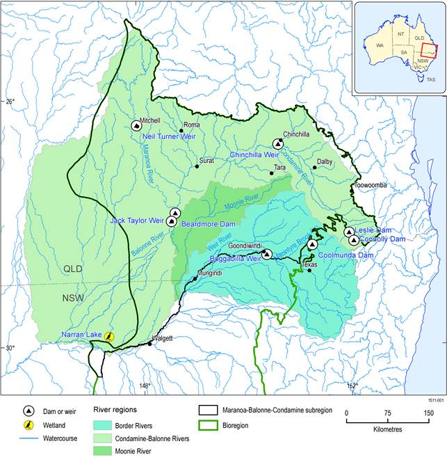
The Maranoa-Balonne-Condamine subregion includes the river basins of the Condamine-Balonne River (including the Maranoa River), the Moonie River and the part of the Border Rivers river basin (37%) that is almost entirely within Queensland (Figure 3). More information about these river basins are available in companion product 1.1 for the Maranoa-Balonne-Condamine subregion (Welsh et al., 2014). The water accounts for these three river basins are described in the subsequent sections.
Data: Bioregional Assessment Programme (Dataset 1), Bureau of Meteorology (Dataset 2), Australian Government Department of the Environment (Dataset 3)
1.5.1.1.1 Water accounts in the Condamine-Balonne river basin
The major surface water resources in the Condamine-Balonne river basin (Figure 4) are the Maranoa, Condamine and Balonne rivers, as well as numerous wetlands, natural lakes and reservoirs and dams. One of the major tributaries of the Condamine-Balonne river is the Condamine River, which has mean annual flow (MAF) of between 18 GL at Brosnans Barn (422341A) and 1312 GL at Bedarra (422344A) (Welsh et al., 2014). The Balonne River is another major tributary of the Condamine-Balonne river basin that has MAF of between 126 GL at St George (422201F) and 1361 GL at Weribone (422213A). The Maranoa River has MAF of 172 GL at Cashmere (422404A) (Welsh et al., 2014).
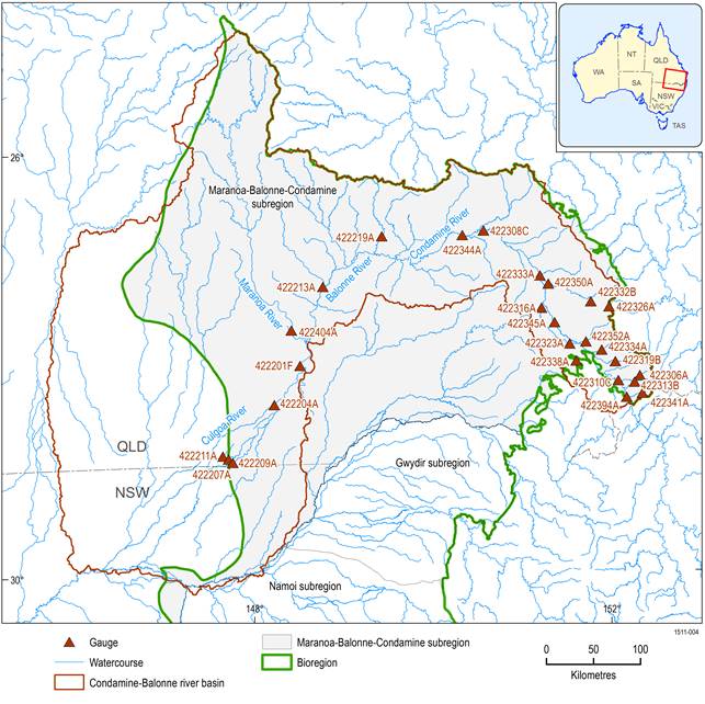
Figure 4 Tributaries of the Condamine-Balonne river basin and streamflow stations
Data: Bureau of Meteorology (Dataset 2, Dataset 4)
There are four major public water storages within the river basin, namely Leslie Dam (106 GL) and Chinchilla Weir (10 GL) on the Condamine River, and Beardmore Dam (82 GL) and Jack Taylor Weir (21.2 GL) on the Balonne River (Figure 3). The Maranoa River is largely unregulated. In addition to these major reservoirs, the Condamine-Balonne river basin has a range of water infrastructure including Cooby Dam and many weirs, most of which are committed to urban, agricultural and irrigation supply schemes (DERM, 2012a). The total volume of major dams, town water supply dams and weirs in the basin is 279.2 GL. There are, however, numerous private offstream water storages (e.g. ring tanks used for floodplain harvesting, runoff dams for stock and domestice use, small dams for irrigation and industrial uses) in the lower parts of the river basin with an estimated combined storage volume of 1916 GL (Webb, McKeown and Associates Pty Ltd, 2007).
1.5.1.1.2 Water accounts in the Moonie river basin
The tributaries of the Moonie river basin (Figure 5) are the Thomby, Bidgel, Farawell, Wongle Wongle, Stephens, Parrie Moolan, Toombilla and Teelba creeks. Teelba Creek is the largest tributary of the Moonie River. The Moonie River produces MAF of between 142 GL at Nindigully (417201B) and 170 GL at Fenton (417204A).
The Moonie river basin has no major public storages, but has about 87 private off-river on-farm storages (DERM, 2013). The total volume of these storages is not accurately known but has been estimated to be 125 GL. These private off-river on-farm water storages are all in hillside dams with their own catchment (Webb, McKeown and Associates Pty Ltd, 2007). The Moonie river basin uses only 0.2% of the total surface water for irrigation. The baseline diversion limit for surface water in the Moonie river basin within Queensland is 84 GL/year, comprising 51 GL/year in interceptions by runoff dams and 33 GL/year in watercourse diversions (MDBA, 2013a). The environmental water requirement for the region is estimated to be between 49 GL/year and 52 GL/year (Bureau of Meteorology, 2013).
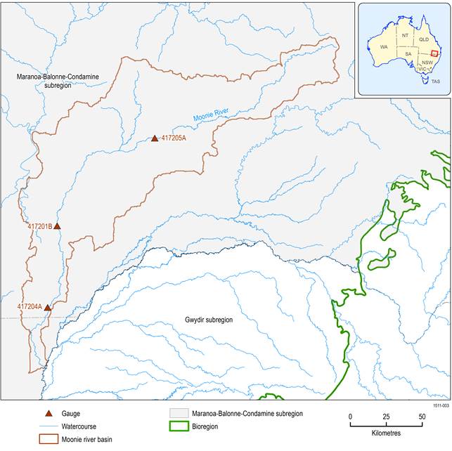
Figure 5 Tributaries of the Moonie river basin and streamflow stations
Data: Bureau of Meteorology (Dataset 2, Dataset 4)
1.5.1.1.3 Water accounts in the Border Rivers river basin
The Maranoa-Balonne-Condamine subregion contains the north-western part of the Border Rivers river basin as shown in Figure 6. The major surface water resources of the basin within the subregion are Weir River, Macintyre Brook, Callandoon Creek and the Macintyre-Dumaresq-Barwon river system. Weir River is a major unregulated river that joins the Macintyre River upstream of Mungindi. The current surface water availability in the Macintyre and Dumaresq rivers is 242 GL/year and in Weir River is also 242 GL/year (CSIRO, 2007). One of the major tributaries of the Border Rivers river basin is the Macintyre River, which produces the maximum MAF of 961 GL at Goondiwindi (461201A) for the entire Border Rivers river basin. The Weir River is another major tributary of the Border Rivers river basin and produces MAF of between 72 GL at Gunn Bridge (416204A) and 252 GL at Mascot (416207A) (Welsh et al., 2014).
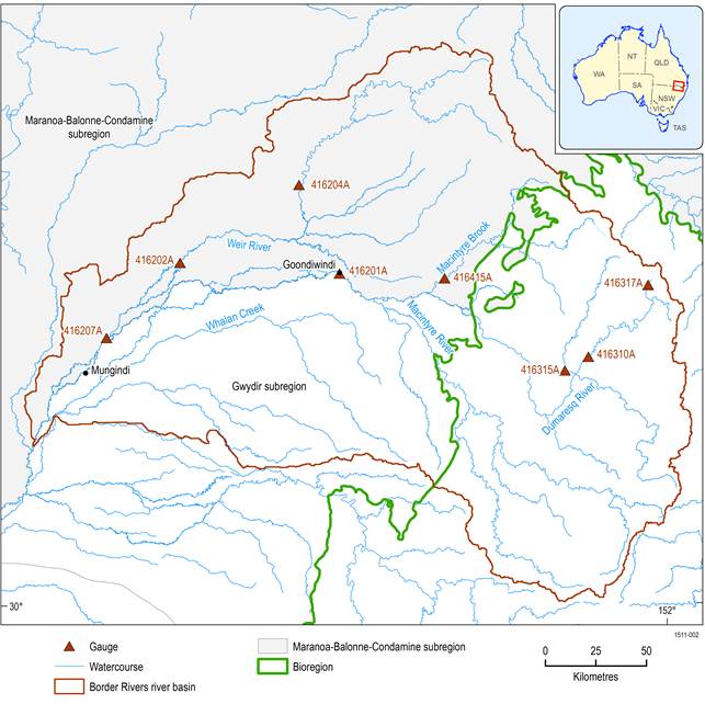
Figure 6 Tributaries of the Border Rivers river basin and streamflow stations
Data: Bureau of Meteorology (Dataset 2, Dataset 4)
Surface water sources comprise more than 90% of the water used for irrigation in the Border Rivers river basin. For the Queensland part of the Border Rivers river basin, the estimated baseline surface water diversion limit is 320 GL/year (Welsh et al., 2014), comprising 78 GL/year (Welsh et al., 2014) in interceptions by runoff dams and 242 GL/year (Welsh et al., 2014) in watercourse diversions (MDBA, 2013b).
The total volume of all major reservoirs, weirs and farm storages is estimated to be about 578 GL for the whole of the Border Rivers river basin, including areas outside of the subregion (Webb, McKeown and Associates Pty Ltd, 2007). Coolmunda Dam on the Macintyre Brook is one of the major public water storage reservoirs in the river basin, with a storage capacity of 69 GL (Figure 3). Macintyre Brook is a regulated stream and supplies medium security water entitlements estimated to be 6.4 GL/year for irrigators from the Coolmunda system (CSIRO, 2007).
1.5.1.1.4 Gaps
Currently, there is little information on how much surface water is actually used by the nominal entitlements in the Maranoa-Balonne-Condamine subregion.
