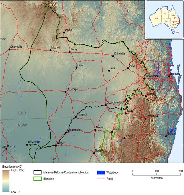
The Maranoa-Balonne-Condamine subregion in the Northern Inland Catchments bioregion is located predominantly within the central and eastern part of the Queensland Murray–Darling Basin, with a small extension into NSW, west of the western margins of the three other subregions in the Northern Inland Catchments bioregion: Gwydir, Namoi and Central West (Figure 3). Its eastern boundary is defined by the Great Dividing Range, its northern boundary by the topographic divide with the Fitzroy river basin, and its south-eastern boundary by the Clarence-Moreton bioregion. The Dumaresq-Macintyre and Barwon rivers delineate the southern boundary, while the western boundary is defined by the western extent of the geological Surat Basin.
The subregion spans an area of 144,890 km2, with elevations ranging from a maximum of 1350 mAHD in the Great Dividing Range (headwaters of the Condamine) to a minimum of about 100 mAHD near Brewarrina in NSW (Figure 4). The subregion extends north and westwards from the headwaters of the Condamine River near Warwick, taking in the prime cropping lands of the Darling Downs and mixed grazing and cropping lands further west. East of Surat, the Condamine River becomes the Balonne River (Figure 5). It flows westward through Surat and then southward to Beardmore Dam, where it is joined by the Maranoa River. Downstream of St George, the river spreads out onto the Upper Darling Plains, where it fans out into a number of distributary channels, including the Culgoa and Bokhara, which discharge into the Barwon-Darling River system, and the Narran River which terminates in the Narran Lakes system. The Macintyre, Moonie and Weir rivers are other significant rivers in the southern part of the subregion. The Moonie and Weir rivers join with the Macintyre north of Collarenebri in NSW. The southern portion of the Macintyre river basin, which is in NSW, is included within the Gwydir subregion. More detail on the surface water hydrology can be found in Section 1.1.5.
Source data: 3 Second SRTM Derived Digital Elevation Model (DEM) version 1.0, GA (2011a)
1.1.2.1.1 Physiographic regions
Physiographic regions are defined by an internal coherence of their landform characteristics and underlying geology (Jennings and Mabbutt, 1986). By implication, they are considered to be areas of similar landform evolutionary history, which have given rise to similar groups of regolith materials. While the mapping criteria relate to landform attributes, the resultant mapped units can be described in terms of landform, underlying geology, regolith and soils (Pain et al., 2011).
The subregion spans a number of physiographic regions (Figure 5). The Toowoomba Plateau to the east of the Upper Condamine River is a basaltic plateau supporting highly weathered bedrock and soil on bedrock surfaces. Taroom Hills to the north is characterised by sandstone ridges with a saprolite drape and shale lowlands covered with alluvial sediments. Saprolite refers to in situ weathered rock, whereas alluvial sediments indicate depositional environments, where the regolith comprises transported material, rather than material that has weathered in place. In the northern Maranoa river basin, the Buckland Plateau is a dissected basaltic and sandstone landscape that adjoins the sandstone strike ridges and clay valleys of Nagoa Scarplands. The regolith of the valleys is alluvial sediments, with saprolite on the slopes. In the low-lying areas, the Condamine Lowlands region is undulating country of siltstone lowlands and sandstone hills with alluvial sediments on the floodplains of the Condamine River and highly weathered bedrock on the slopes. The sandplains of the St George Plain and the anastomosing river floodplains of the Upper Darling Plains are broken by a ridge of stony plains and minor silcrete-capped mesas of the Lightning Ridge Lowland. The Charleville Tableland in the centre and west is the largest physiographic region in the subregion, and is a low sandy tableland of weathered sandstone and shale.
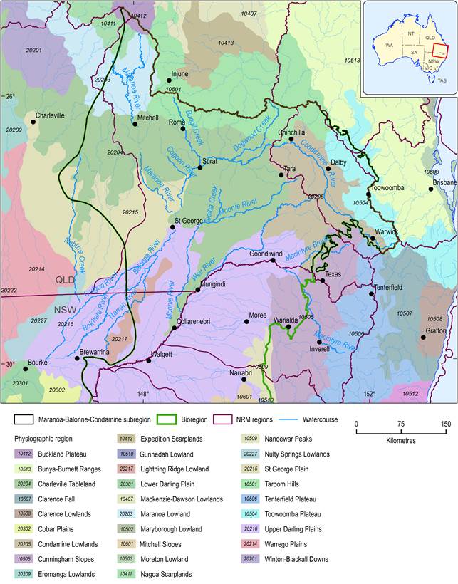
Figure 5 Physiographic regions
As defined in Pain et al. (2011)
1.1.2.1.2 Soils and land capability
Figure 6 shows the soils of the subregion based on the Australian Soil Classification (Isbell, 2002) and Table 2 summarises area (km2) and extent (%) of coverage. The Upper Condamine valley and the floodplains of the St George Plain and Upper Darling Plains are dominated by Vertosols, clay soils with shrink-swell properties that exhibit strong cracking when dry. From an agricultural perspective, they are well structured and have a good mix of pores for both transmitting and storing water and high soil fertility, so plant growth on these soils is typically very good relative to other soil types. Because Vertosols can be worked under a very narrow range of moisture conditions, they are better suited to irrigated cropping rather than rain-fed cropping. Given their self-mulching properties, they can withstand comparatively frequent cultivation without changes to structure.
In addition to some areas of Vertosols, the western half of the Condamine Lowlands is dominated by Sodosols, which are soils with strong texture contrast between A horizons and sodic B horizons and disproportionately high levels of exchangeable sodium ions. This makes them quick to disperse in water and highly erodible and best suited to low intensity land uses, such as production forestry and grazing from relatively natural environments. Kandosols are extensive throughout the Charleville Tableland, the St George Plain and the Lightning Ridge Lowland. The Kandosols are red, yellow and grey massive earthy soils. They generally have a sandy to loamy surface soil, grading to porous sandy clay subsoils with low fertility and poor water-holding capacity. A wide range of crops can be grown on these soils where rainfall is higher or where irrigation is available. The Charleville Tableland, Maranoa Lowland and Taroom Hills have large areas dominated by Dermosols. These soils can be red, brown, yellow, grey or black and have loam to clay textures. The land tends to be used for livestock grazing from relatively natural environments. Tenosols dominate the Nagoa Scarplands, Buckland Plateau and Maranoa Lowland in the north-west. They tend to be low fertility, low water-holding capacity soils and are often shallow and stony. Production forestry and grazing from relatively natural environments occur in these areas (DNRM, 2010a). Overall, the land and soil resources of the subregion mean that the majority of the area is deemed ‘good quality agricultural land’ (QMDC, 2008).
Bell et al. (2010) investigated soil fertility in the major grain growing areas of Queensland in 2008 and found that soil fertility was declining at all studied sites. On average, cropped soils contained 60% less organic carbon, 48% less total organic nitrogen, 36% less particulate nitrogen, 68% less inorganic phosphorus and 55% less exchangeable potassium than uncropped reference sites (Bell et al., 2010).
Soil acidification is a problem across much of the cropping and grazing country, particularly on soils which have a naturally low pH or a low capacity to buffer against pH decreases and where past and/or current management practices are highly acidifying. In the subregion, 12% of lands (i.e. in western Condamine river basin and the lower Balonne) are estimated to be at high risk of soil acidification, while a further 31% (predominantly in the northern subregion) are at moderate risk (Barson, 2013).
Moderate to high salinity hazard areas include the Sodosols, Vertosols and Dermosols along the Upper Condamine, near Warwick, along the Moonie River, Macintyre River and lower Balonne floodplains and on the alluvial fan system downstream of St George, and these need to be managed to minimise hydrological changes which could mobilise stored salts. Small areas of irrigation salinity occur around St George, in the lower Border River alluvium and in the Granite Belt. Surface expressions of dryland salinity can be very climate dependent; saline sites occur around Roma and near Weengallon (between Goondiwindi and St George). These usually occur on footslopes at the contact with alluvium and do not appear to involve groundwater discharge (Biggs et al., 2010).
In recognition of the significance of agriculture for the Queensland and national economy and in response to widespread degradation of the land and soil resource due to erosion, declining soil fertility, salinity and deteriorating pasture condition, the Queensland Government enacted State Planning Policy 1/92 – Development and Conservation of Agricultural Land under the Local Government (Planning and Environment) Act 1990 in 1992. This instrument provides guidance to local authorities on conserving good quality agricultural land in the public interest when carrying out their planning functions. The overarching principle of the instrument is that ‘good quality agricultural land has a special importance and should not be built on unless there is an overriding need for development in terms of public benefit and no other site is suitable for the particular purpose’ (Queensland Government, 1992).
Table 2 Soils, classified using Australian Soil Classification (Isbell, 2002)
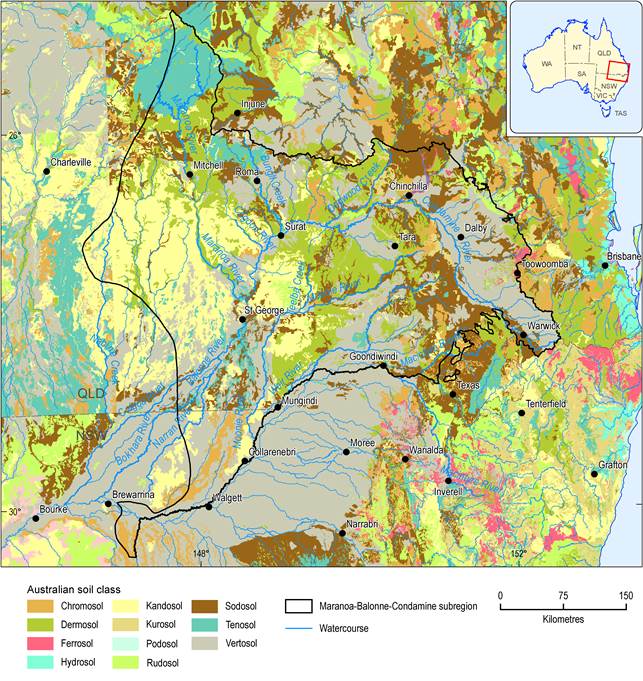
Figure 6 Soils classified using the Australian Soil Classification
Inconsistencies across the NSW-Queensland boundary are an artefact of the state-based mapping programs from which the national composite soils map was compiled.Source data: National Soil Grids (ASRIS, 2011)
More recently, Queensland has committed to protecting its best cropping lands from developments that would have an adverse impact on the productive capacity of the land. Queensland’s Strategic Cropping Land Act 2011, which commenced on 30 January 2012, has the objectives of protecting land that is highly suitable for cropping, managing the impacts of development on that land, and preserving the productive capacity of that land for future generations. Figure 7 shows the areas protected under this legislation. There is a very close correspondence with the areas of Vertosols across much of the subregion.
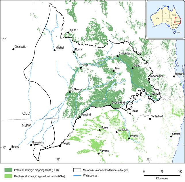
Figure 7 Strategic cropping lands
Source data: Trigger Map for Strategic Cropping Land in Queensland (DNRM, 2012) and Strategic Agricultural Lands (NSW Government, 2013)
Under Queensland's Environmental Protection Act 1994 and Land Act 1994, all landholders have a duty of care to the land, which requires them to take all reasonable and practical steps to prevent harm to the environment, including land degradation.
In late 2012, the NSW government introduced its Strategic Regional Land Use Policy to protect valuable residential and agricultural land across the State from the impacts of mining and Coal Seam Gas (CSG) activity (NSW Government, 2014). Information was released in January 2014, identifying the areas of Biophysical Strategic Agricultural Land (BSAL) - land of high quality soil and water resources capable of supporting high levels of agricultural production - across NSW, which are deemed necessary to support the state's $12 billion per year agricultural industry (Figure 7).
1.1.2.1.3 Land cover
Figure 8 shows the land cover for the subregion in 2008, based on remotely sensed data that are post-processed to convert vegetation greenness to a land cover type (GA, 2011b). The Upper Condamine valley is notable for the predominance of cropping, with other significant areas of cropping on the Balonne, around Roma and in the Moonie and Macintyre river valleys. Crop and pasture account for almost 17% of the land cover in the subregion. There are small areas of open woodlands in higher parts of the river basin, but sparse to scattered woodlands cover most of the subregion (68%), with increasing areas of tussock and hummock grasses to the west (Table 3).
The subregion has undergone significant modification of its land cover, with most areas having between 10 and 30% of their pre-clearing vegetation, the exception being the western part of the Condamine Lowlands physiographic region with almost 60% of its original extent. Since the introduction of Queensland's Vegetation Management Act 1999, land clearing rates have fallen dramatically. Between 1997 and 2005, annual rates of clearing in the west of the subregion were occurring at greater than 3.6% of starting vegetation in some areas, and between 0.6 to 3.6% elsewhere. In the east clearing rates have tended to be lower. Between 2005 and 2009, clearing in the east was at 0.05 to 0.1% per year of existing native cover and between 0.1 and 3.6% in more western areas (Accad et al., 2012). Most of the land cleared is for pasture, followed by infrastructure and forestry. Between 2004 and 2009, approximately 200,000 ha were cleared for pasture and 900 ha for mining (DNRM, 2010b; DNRM, 2010c) of which 55,000 ha were remnant vegetation. Woody vegetation (remnant and regrowth) covers 42% of the subregion.
Communities listed under the Commonwealth's Environment Protection and Biodiversity Conservation Act 1999 in the subregion are discussed in Section 1.1.7. Estimates of the extent of these communities pre-clearing was 25% (6.5 million ha) of the Queensland Murray-Darling Basin. Now the extent is 3.2% of the Queensland Murray-Darling Basin, or 13% (0.8 million ha) of its original extent. The slopes east of Warwick, the headwaters of the Maranoa River, the floodplains of the Maranoa and Balonne rivers and the alluvial outwash areas of the Balonne River downstream of St George are the main areas where these endangered ecological communities can still be found. The ecology of the subregion is covered in more detail in Section 1.1.7.
Some endangered ecological communities and species are protected in nature conservation areas: the Main Range National Park on the eastern divide of the subregion is part of the Gondwana Rainforest World Heritage area and contains the world's most extensive subtropical rainforest and nearly all of the world's Antarctic beech cool temperate rainforest. There are few places on Earth containing so many plants and animals that have remain relatively unchanged from their ancestors in the fossil record (Department of the Environment, 2013). Bunya Mountains National Park to the north-east of Dalby contains the largest stand of ancient bunya pines in the world (South Burnett Tourism, 2013). In the Southwood National Park, south-west of Dalby, Brigalow-belah forest remnants are conserved. Few intact examples of this vegetation type remain on the Darling Downs. Cypress pine, poplar box, wilga bush, false sandalwood, western teatree and other plant species common throughout the semi-arid lands also grow in the park (DNPRSR, 2013).
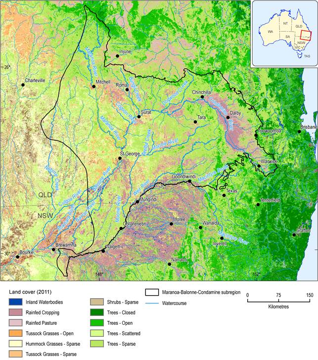
Figure 8 Land cover in the Maranoa-Balonne-Condamine subregion
Source data: The National Dynamic Land Cover Dataset, GA (2011b)The methods used to produce the land cover map are not very sensitive to use of irrigation water and irrigated land covers are often mapped as rainfed covers. For irrigated land covers, the land use map (Figure 9) should be consulted.
Inland waterbodies and wetlands are mapped as covering 400 km2 (0.3%) of the subregion. The Balonne River floodplain and Gums Lagoon are both listed as nationally important. The Balonne River floodplain is a small area of a couple of hundred hectares within the larger 24,000 ha floodplain area. It contains a significant aggregation of permanent and ephemeral freshwater billabongs and swamps on an inland floodplain. Despite major agricultural disturbance, the fringing and aquatic vegetation of the wetlands are reasonably intact, although there are ongoing pressures from the current land uses, which include high intensity irrigated agriculture, extensive grazing on native pasture, recreational fishing and water storage. The 343 ha Gums Lagoon (west of Dalby on the Surat road) supports a low open forest of river red gum over perennial tussock grasses. Ephemeral semi-aquatic plants occur during periods of inundation. It is significant because it is a relatively undisturbed wetland in a region of extensive habitat modification. Large numbers of waterbirds and fish are known to use the lagoon when it is full. The historical loss of wetlands is up to 70% across the Queensland Murray-Darling Basin. Ongoing loss over the 2001 to 2005 and 2005 to 2009 periods continues with the Maranoa losing wetlands at greater than 1% of 2001 extent (Queensland Government DEHP, 2012).
While the Ramsar-listed wetlands of the Narran Lakes system and the Culgoa River Floodplain are not in the subregion, the rivers draining this subregion supply water to these nationally important wetlands.
Table 3 Land cover
