All potential impacts due to unconventional gas resource development identified by the assessment can be mitigated through ongoing compliance with existing regulatory and management controls.
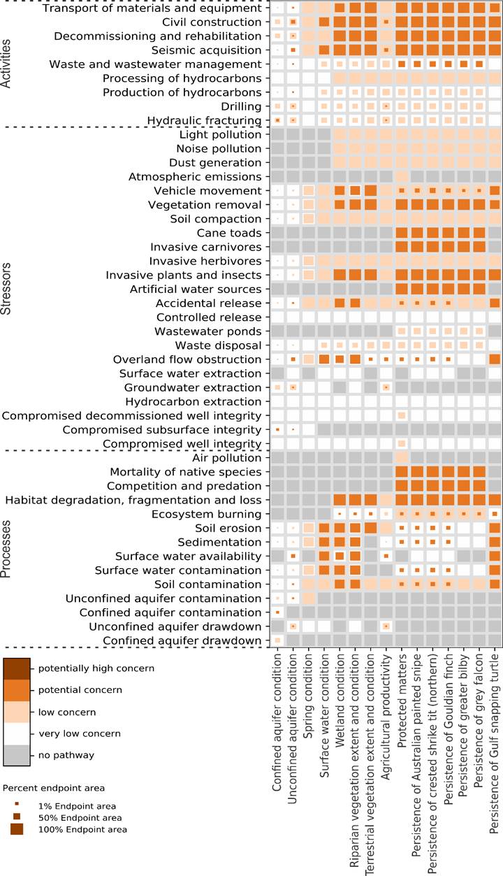
The impact assessment for the Beetaloo GBA region determined (i) areas of concern (how much of an endpoint area is of a particular level of concern), (ii) activities, stressors and processes of concern, and (iii) potential impacts on landscapes, aquifers, springs, wetlands and selected protected fauna. The causal network for the Beetaloo GBA region consists of 1 driver node, 9 activity nodes, 23 stressor nodes, 14 process nodes and 15 endpoints ( nbsp; Table 1 ). Potential impacts due to stressors associated with unconventional gas resource development on water, the environment and selected protected matters are conceptualised in Figure 3 and Figure 4 .
The selected 15 endpoints in the causal network for the Beetaloo GBA region represent values pertaining to water and the environment that may be impacted by development of unconventional gas resources. These endpoints represent: (i) landscapes – agricultural productivity, terrestrial vegetation, riparian vegetation, wetlands and springs; (ii) water – surface water and subsurface water (aquifers); and (iii) protected fauna – 4 bird species (Australian painted snipe, crested shrike-tit (northern), Gouldian finch and grey falcon), 1 marsupial (greater bilby) and 1 aquatic reptile (Gulf snapping turtle). Impact assessment results include a spatial assessment that shows how much of the endpoint’s extent may be affected by pathways of concern ( Figure 7 ). his spatial assessment does not distinguish between the relative importance of different components of the extent of an endpoint (for example, characteristics of the breeding and foraging habitats of Gouldian finch) or where any future potential impacts (for example, loss of critical food sources) may be more important to an individual endpoint.
FIGURE 7 Results of the impact assessment for the Beetaloo GBA region based on the causal network