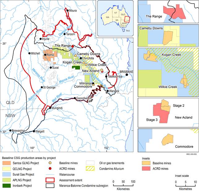
The Maranoa-Balonne-Condamine subregion covers 144,890 km2 and includes the headwaters of the Condamine River and the Maranoa River as well as the floodplains of the Upper Darling Plains (Figure 1). The main population centres are Chinchilla, Dalby, Goondiwindi, Roma, St George, Toowoomba and Warwick.
This assessment focused on water-dependent landscapes and assets that are potentially impacted by changes in groundwater due to additional coal resource development (Box 2). The assessment extent covers an area of 129,956 km2.
The main natural and human-modified ecosystems in the assessment extent were categorised in a landscape classification (Box 7), which was based on the subregion’s geology; the physical features of the region, known as geomorphology; hydrogeology, which describes the way water moves underground; land use; and ecology. See ‘What are the potential impacts of additional coal resource development on the landscape?’ for more information.
Assets were identified for their ecological, economic, or sociocultural values, such as a wetland providing habitat for waterbirds, river water used for agriculture, or a sacred site with cultural significance. See ‘What are the potential impacts of additional coal resource development on water-dependent assets?’ for more information.
Important groundwater systems in the subregion are alluvial aquifers associated with major rivers, including the Condamine Alluvium; basalt aquifers associated with the Main Range Volcanics geological formation; and the deeper confined aquifers of the Surat Basin, which are part of the larger Great Artesian Basin (GAB).
Coal resource development
The coal resource development pathway (Box 2) is the most likely future for the subregion and includes five baseline open-cut coal mines, five baseline coal seam gas developments and two additional coal resource developments that are open‑cut coal mines: New Acland Coal Mine Stage 3 south-east of Dalby and The Range coal mine in the north between Chinchilla and Taroom.Key finding 1
Coal is extracted from open-cut mines in the Clarence-Moreton and Surat geological basins. Although the southern part of the Bowen Basin underlies the Surat Basin in the subregion, it contains no economic coal deposits. The major coal deposits in the Walloon Coal Measures in the Surat Basin occur near Brigalow, Chinchilla and Macalister.
The five baseline open-cut coal mines in the subregion are Cameby Downs Mine, Commodore Mine, Kogan Creek Mine, New Acland Coal Mine Stage 2 and Wilkie Creek Mine (which ceased operations in December 2013) (Figure 1).
CSG is extracted from the deeper resources of the Walloon Coal Measures of the Surat Basin in the central-northern and central-eastern part of the subregion between Roma and Millmerran. No significant reserves of CSG are known in the most north-western part and the eastern part of the subregion due to the proximity to the margins of the geological basin.
CSG development in the subregion has escalated in the recent past, as illustrated by construction of three large-scale liquified natural gas (LNG) export plants on Curtis Island near Gladstone, Queensland. A large portion of the gas to be supplied to the LNG plants will be extracted from the Walloon Coal Measures in the subregion and transported to Curtis Island via pipelines. (LNG is any type of natural gas, such as CSG, that has been cooled into liquid form for storage and transport.)
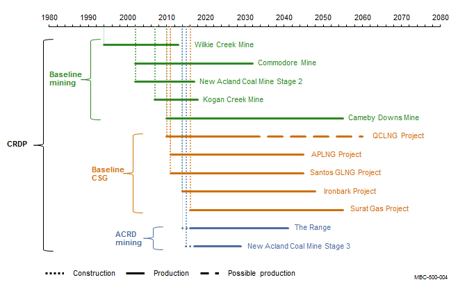
For this assessment, the five CSG gas fields included in the baseline are Australia Pacific LNG Project, Santos Gladstone LNG Project, Queensland Curtis LNG Project, Surat Gas Project and Ironbark Project. To be consistent with OGIA, the CSG developments reported in Queensland’s Office of Groundwater Impact Assessment (OGIA) Annual report 2014 for the Surat underground water impact report (OGIA, 2014) are all deemed to be in the baseline even though the Ironbark and Surat Gas projects had not commenced commercial operation as of December 2012 (which is the standard cut-off to be included in the baseline). The timeline of construction and production for each coal resource development represented in the adapted OGIA groundwater model is shown in Figure 2.
Coal seam gas (CSG) production is shown by the extent of petroleum and gas tenures, which are all in the baseline. Some of these tenures are located outside the subregion, but are included in the coal resource development pathway (CRDP) as they contain gas fields located partially within the subregion. The coal resource developments in the CRDP are the sum of those in the baseline and the additional coal resource development (ACRD). All petroleum tenures shown are part of the baseline.
APLNG Project = Australia Pacific LNG Project, LNG = Liquefied Natural Gas, QCLNG Project = Queensland Curtis LNG Project, Santos GLNG Project = Santos Gladstone LNG Project + GLNG Gas Field Development Project
Data: Bioregional Assessment Programme (Dataset 1), Queensland Department of Natural Resources and Mines (Dataset 2)
The CRDP for the subregion (Box 2) is based on known coal resource development proposals as of July 2015. However, proposals may have changed since then and may continue to change into the future.
This assessment focused on the potential cumulative impact of the two proposed open-cut coal mines, referred to as additional coal resource development: New Acland Coal Mine Stage 3, an extension to the existing New Acland Coal Mine in the east, and The Range, a proposed open-cut coal mine in the north of the subregion.
For the baseline coal seam gas (CSG) projects, construction and production occurs concurrently due to the staged development process. The coal resource developments in the CRDP are the sum of those in the baseline and the additional coal resource development (ACRD).
APLNG Project = Australia Pacific LNG Project, LNG = Liquefied Natural Gas, QCLNG Project = Queensland Curtis LNG Project, Santos GLNG Project = Santos Gladstone LNG Project + GLNG Gas Field Development Project
Context statement, product 1.1 (Welsh et al., 2014) Coal and coal seam gas resource assessment, product 1.2 (Sander et al., 2014) Description of the water-dependent asset register, product 1.3 (Mitchell et al., 2015) Water-dependent asset register (Bioregional Assessment Programme, 2017) Conceptual modelling, product 2.3 (Holland et al., 2016) Groundwater numerical modelling, product 2.6.2 (Janardhanan et al., 2016) Compiling water-dependent assets, submethodology M02 (Mount et al., 2015) Developing a coal resource development pathway, submethodology M04 (Lewis, 2014) FIND MORE INFORMATION

Product Finalisation date
- Explore this assessment
- About the subregion
- How could coal resource development result in hydrological changes?
- What are the potential hydrological changes?
- What are the potential impacts of additional coal resource development on the landscape?
- What are the potential impacts of additional coal resource development on water-dependent assets?
- How to use this assessment
- Building on this assessment
- References and further reading
- Datasets
- Contributors to the Technical Programme
- Acknowledgements
- Citation


