A hazard analysis was conducted for the Gloucester subregion based on the existing and proposed coal mines and CSG operations and their water management outlined in Section 2.3.4.1 and Section 2.3.4.2, respectively. The hazard analysis for the Gloucester subregion was conducted over five days via workshops with a range of experts present from CSIRO, Geoscience Australia and the Department of the Environment. Specific coal resource expertise within these agencies was included beyond the BA Assessment teams, and subsequent hazard analysis workshops for other subregions, which had stronger external representation, have assisted in confirming the comprehensiveness of the hazards identified for the Gloucester subregion.
A total of 261 activities were identified for CSG operations and 351 activities for open-cut coal mines. These activities were all identified during the IMEA; however, the results are based on a subset of activities with complete scores. All decisions were recorded; however, some activities were left unscored if they were considered not applicable to the Gloucester subregion or if that activity was not expected to occur at the time of the assessment.
2.3.5.2.1 Coal seam gas operations
The hazard analysis identifies impacts on aquifers as the highest ranked potential hazard associated with CSG operations in the Gloucester subregion. The hazard analysis identifies the following ways in which aquifer impacts may occur including:
- hydrostatic depressurisation of the target coal seam
- fault-mediated depressurisation and pressurisation caused by faults opening or closing due to CSG operations
- aquitard-mediated depressurisation (i.e. an aquitard is absent or the integrity of the aquitard is compromised in some parts of the subregion)
- connection of previously disconnected aquifers by hydraulic fracturing or incomplete casing of wells.
After impacts on aquifers, the potential impacts associated with using co-produced water for irrigation rate as high-priority hazards. Increased discharges to surface water, raised groundwater levels, soil salt mobilisation and changes to soil chemistry were all identified as potentially important in this context.
Figure 13 plots the 30 highest ranked potential hazards (and associated activities and impact modes), ranked by midpoint of the hazard priority number. This figure shows the range of hazard scores and hazard priority numbers for each of these potential hazards.
Disruption to natural surface drainage was the most common impact mode in the top 30 highest ranked potential hazards. This impact mode appears 24 times in the IMEA for CSG operations in the Gloucester subregion, and 8 times in the top 30 hazards, because many of the activities associated with CSG operations (such as site vegetation removal and diverting site drain lines) lead to this impact mode. This impact mode is identified as hazardous as it may lead to impacts on surface water volume, direction and quality; in extreme cases, impacts on groundwater quantity were identified as a possible outcome.
The following complete the list of high-priority hazards that might potentially impact on water-dependent assets in the Gloucester subregion for CSG operations:
- gas leakage into groundwater caused by incomplete or compromised cement casing
- subsidence
- leaching from brine storage ponds, pumps, water disposal pipelines and hyper-saline brine ponds
- soil erosion following heavy rainfall, with total suspended solids (TSS) as the associated stressor
- future loss of seal integrity after decommissioning of CSG wells.
Details of the full hazard analysis are available at Bioregional Assessment Programme (Dataset 1).
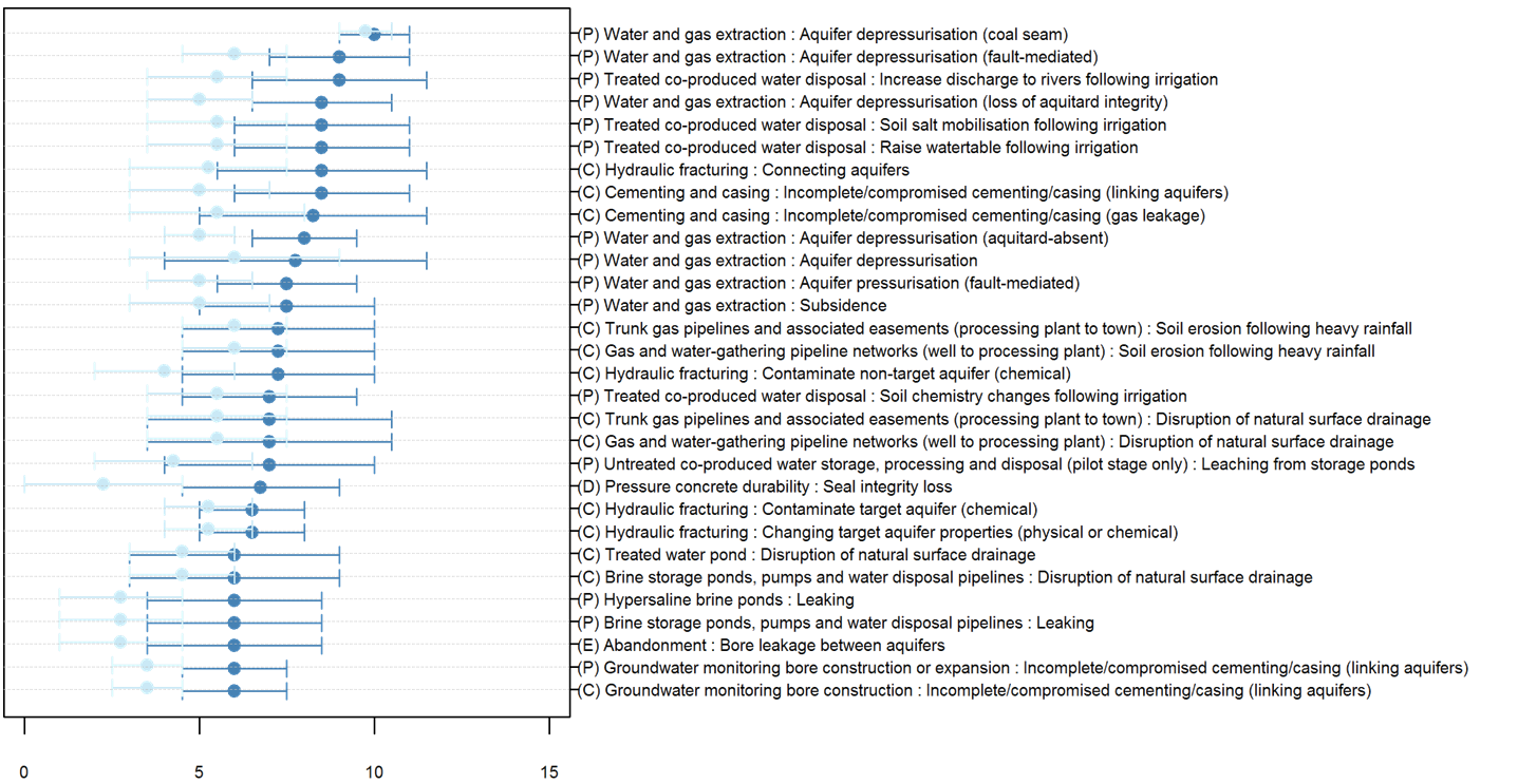
The x-axis shows the hazard priority number and hazard score for potential hazards. The intervals between the highest and lowest hazard priority number are shown in dark blue; the intervals for hazard score are shown in light blue. The same hazard may appear multiple times, as it may arise from a number of different life cycles and activities. Hazards are listed with the syntax [Life‑cycle stage][Activity]:[Impact mode], where life-cycle stages are indicated by (E) for exploration and appraisal, (C) for construction, (P) for production, (D) for decommissioning and (W) for work-over.
Data: Bioregional Assessment Program (Dataset 1)
2.3.5.2.2 Open-cut coal mines
Activities that lead to disruption of, and changes to, natural surface drainage and runoff associated with open-cut mines in the Gloucester subregion are associated with six of the 30 highest ranked potential hazards. These potential impacts occur because open-cut coal mines may potentially divert rivers and creeks, and divert the natural direction of rainfall-runoff by the construction, or expansion of, the pit and associated mine infrastructure and work areas, and by re-contouring landforms and discharges.
The potential impact of leaching is associated with 7 of the 30 highest ranked potential hazards, including leaching from:
- in-pit waste rock dumps
- waste rock dumps outside of the pit
- coal stockpiles (in and out of the pit)
- run-of-mine (ROM) plants.
The following were identified as having the potential to link, or cause leakage between, aquifers:
- incomplete or compromised cementing casing of groundwater monitoring bores
- supply bores
- mine dewatering bores
- abandoned exploration and appraisal bores.
These – together with deliberate pit wall dewatering, subsidence and enhanced aquifer interconnectivity caused by post-closure water filling the pit – were identified as potentially important hazards. The remaining 30 highest ranked potential hazards include:
- soil erosion caused by heavy rainfall or failure to successfully rehabilitate abandoned mines
- artificial groundwater recharge (following pit abandonment)
- groundwater and surface water contamination via drill cutting disposal
- negligent decontamination of mines post closure.
Figure 14 plots the 30 highest ranked potential hazards (and their associated activities and impact modes), ranked by midpoint of their hazard priority number. The figure shows the range of hazard scores and hazard priority numbers for each of these hazards.
Details of the full hazard analysis are available at Bioregional Assessment Programme (Dataset 1).
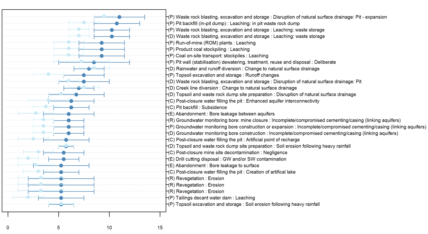
The x-axis shows the hazard priority number and hazard score for potential hazards. The intervals between the highest and lowest hazard priority number are shown in dark blue; the intervals for hazard score are shown in light blue. The same hazard may appear multiple times, as it may arise from a number of different life cycles and activities. Hazards are listed with the syntax [Life‑cycle stage][Activity]:[Impact mode], where life-cycle stages are indicated by (E) for exploration and appraisal, (D) for development, (P) for production, (C) for closure and (R) for rehabilitation.
Data: Bioregional Assessment Program (Dataset 1).
The hazard analysis also indicates the possibility of cumulative impacts associated with vegetation removal and diversion of site drainage lines around CSG plants, mines and pipeline corridors. Individually these hazards are not deemed to be relatively important, but they were in the top five ranked impact causes for activities associated with open-cut coal mines and CSG operations. These hazards are deliberate and associated with many activities, and are therefore likely to contribute to other stressors in the environment.
2.3.5.2.3 Hazard handling and scope
A full list of hazards has been generated for both coal mines and CSG operations. The hazards of primary focus from a BA perspective are those that extend beyond the development site and that may have cumulative impacts, as these are consistent with the regional focus of BA, and are where BA will add value beyond site-specific environmental impact statements (EIS). Ultimately, however, BAs need to be able to address all identified hazards by considering the scope, modelling, other literature or narratives, and specifying where science gaps may exist.
BAs are constrained by considering only impacts that can happen via water, and so hazards such as dust, fire or noise are deemed out of scope and are addressed by site-based risk management unless there is a water-mediated pathway.
Best practice is assumed and accidents are deemed to be covered adequately by site-based risk management procedures and are beyond the scope of BA; for example, the failure of a pipeline is covered by site-based risk management.
Hazards that pertain to the development site and with no off-site impacts are important to acknowledge but will typically be addressed by site-based risk management procedures.
For CSG operations, the following hazards are considered out of scope for further analysis as part of the bioregional assessment of the Gloucester subregion, because they are deemed to be covered by site-based risk management and regulation:
- abandonment practice
- hazards addressed by site management, no water-mediated pathway (dust, fire or noise)
- containment failure due to construction or design
- disruption of surface drainage network for site-based infrastructure, plant and facilities, roads, creek crossings
- equipment/infrastructure failure (e.g. pipeline failures)
- leaching/leaking from storage ponds and stockpiles
- spillages and disposals (diesel, mud, cuttings, fluid recovery)
- vegetation clearance and subsequent soil erosion following heavy rainfall.
Figure 15 and Table 9 describe all hazards associated with CSG operations that are considered to be in scope in the Gloucester subregion. The hydrological effect of an activity such as ‘water and gas extraction’ depends on the impact cause and impact mode. For example, ‘depressurisation’ (impact cause) that causes ‘subsidence’ (impact mode) affects ‘surface water direction’ (hydrological effect) and ‘aquitard leaks’ (impact cause) that cause ‘non-target, non-reservoir aquifer depressurisation’ (impact mode) affects ‘groundwater pressure’ (hydrological effect) (Figure 15).
Hydrological effects associated with CSG operations that are considered to be in scope in the Gloucester subregion are shown in Figure 15 and listed below:
- surface water quality
- surface water direction
- surface water flow
- surface water quantity/volume
- soil quality
- groundwater quality
- aquifer properties
- groundwater composition
- groundwater flow (reduction)
- groundwater level
- groundwater pressure
- groundwater quantity/volume.
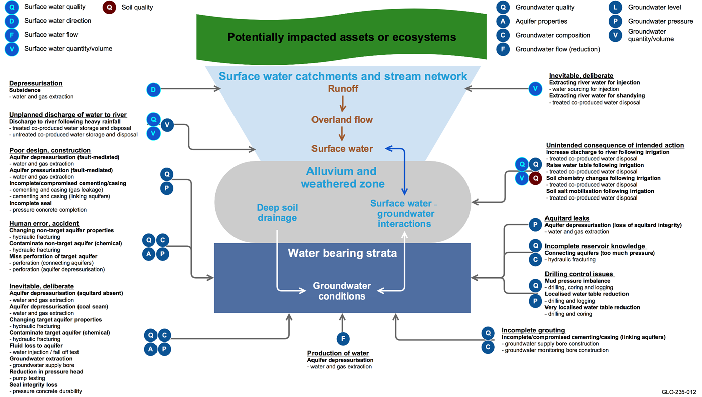
Impact causes are underlined, impact modes are bold and activities are bullet points. Arrows indicate the spatial context for each hazard: aquifers, aquifer outcrop areas, watercourses, catchments.
GDEs = groundwater-dependent ecosystems; groundwater composition = mixing groundwater of different composition (in terms of natural dissolved solids)
Typology and punctuation are consistent with the hazard analysis (Bioregional Assessment Programme, Dataset 1).
Table 9 Hazards identified for the life-cycle stages of coal seam gas operations that are considered to be in scope in the Gloucester subregion and their associated hydrological effects, spatial context, temporal context, and potentially impacted assets or ecosystems
This table lists each hazard (with its spatial and temporal context) in a chain of logic from hydrological effects to potentially impacted assets or ecosystems. The spatial context includes target and non-target aquifers, aquifer outcrop areas, coal resource development areas and watercourses. Within the relevant spatial and temporal context, assets and ecosystems are described using landscape classification rule sets, landscape class group (e.g. ‘Floodplain or lowland riverine’) or asset type (e.g. economic = economic groundwater asset).
alife-cycle stage of coal seam gas operations, where C = construction; D = decommissioning; E = exploration and appraisal; P = production; W = work-over
bshort term = less than 5 years; medium term = 5 to 10 years; long term = 10 to 100 years
CSG = coal seam gas; GDEs = groundwater-dependent ecosystems; GW = groundwater; SW = surface water; GW composition = mixing groundwater of different composition (in terms of natural dissolved solids)
Typology and punctuation are consistent with the hazard analysis (Bioregional Assessment Programme, Dataset 1).
Data: Bioregional Assessment Programme (Dataset 1)
For open-cut coal mines, the following hazards are considered out of scope in the Gloucester subregion because they are deemed to be covered by site-based risk management and regulation and do not have cumulative effects on water in the subregion:
- hazards addressed by site management, no water-mediated pathway (dust, fire or noise)
- bore and well construction (integrity, leakage)
- disruption of surface drainage network for site-based infrastructure, plant and facilities, roads, creek crossings
- equipment/infrastructure failure (e.g. pipeline failures, plant failures)
- leaching/leaking from storage ponds and stockpiles
- loss of containment (due to construction or design, slope failure)
- re-contouring, compaction and settlement following backfill
- spillages and disposals (diesel, mud, cuttings, fluid recovery)
- vegetation clearance and subsequent soil erosion following heavy rainfall.
Of those hazards that are in scope, some will be addressed by the BA numerical modelling, while others (e.g. water quality hazards) will be assessed qualitatively, using the logic and rule-sets described in the conceptual model of causal pathways. The hazard priority number or hazard scores indicate the relative importance of the hazard. Hazards with low scores are of lower priority.
Figure 16 and Table 10 describe all hazards associated with coal mining developments that are considered to be in scope in the Gloucester subregion. The hydrological effect of an activity such as ‘water management structures’ depends on the impact cause and impact mode. For example, the hydrological effect of ‘poor handling/management’ (impact cause) can cause ‘excessive runoff during closure’ (impact mode) that affects ‘surface water quality and groundwater quality’ (hydrological effects) and ‘diverting site drain line’ (impact cause) can cause ‘disruption of natural surface drainage’ (impact mode) that affects ‘surface water volume/quantity, surface water quality and groundwater quantity/volume’ (hydrological effect). Hydrological effects associated with coal mines that are considered to be in scope in the Gloucester subregion are shown on Figure 16 and listed below:
- surface water quality
- surface water direction
- surface water flow
- surface water volume
- groundwater quality
- groundwater direction
- groundwater flow (reduction)
- groundwater quantity/volume
- groundwater pressure.
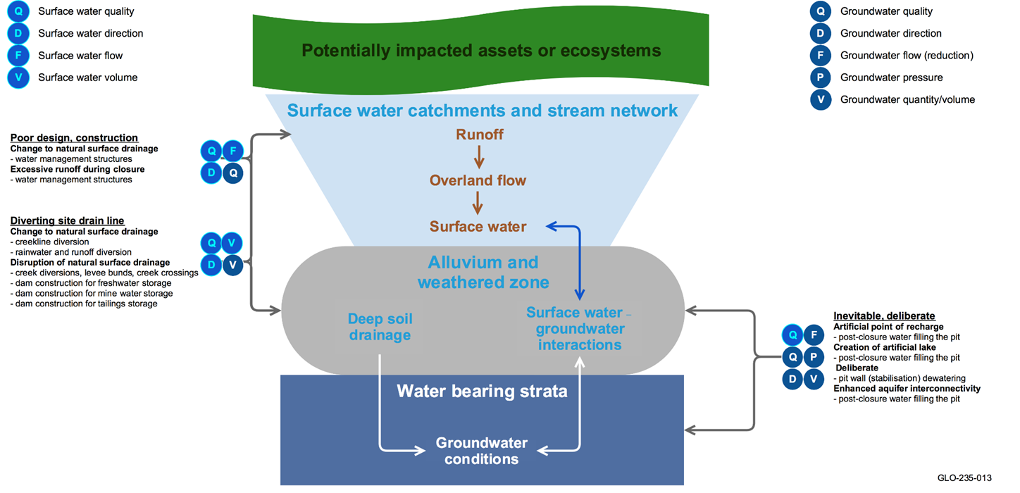
Impact causes are underlined, impact modes are bold and activities are bullet points. Arrows indicate the spatial context for each hazard: aquifers, aquifer outcrop areas, watercourses, catchments.
GDEs = groundwater-dependent ecosystems
Typology and punctuation are consistent with the hazard analysis (Bioregional Assessment Programme, Dataset 1).
Table 10 Hazards identified for the life-cycle stages of open-cut coal mines that are considered to be in scope in the Gloucester subregion and their associated hydrological effects, spatial context, temporal context, and potentially impacted assets or ecosystems
This table lists each hazard (with its spatial and temporal context) in a chain of logic from hydrological effects to potentially impacted assets or ecosystems. The spatial context includes target and non-target aquifers, aquifer outcrop areas, coal resource development areas and watercourses. Within the relevant spatial and temporal context, assets and ecosystems are described using landscape classification rule sets, landscape class group (e.g. ‘Floodplain or lowland riverine’) or asset type (e.g. economic = economic groundwater asset).
alife-cycle stage of coal mine where C = mine closure; D = development; E = exploration and appraisal; P = production; R = rehabilitation
bmedium term = 5 to 10 years; long term = 10 to 100 years
GDEs = groundwater-dependent ecosystems;GW =groundwater; SW = surface water
Typology and punctuation are consistent with the hazard analysis (Bioregional Assessment Programme, Dataset 1).
Data: Bioregional Assessment Programme (Dataset 1)
