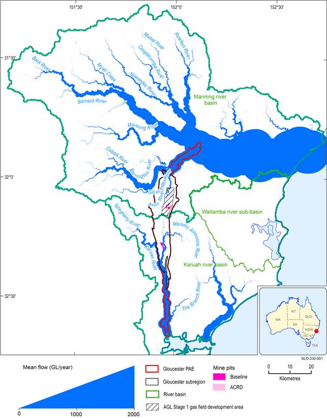
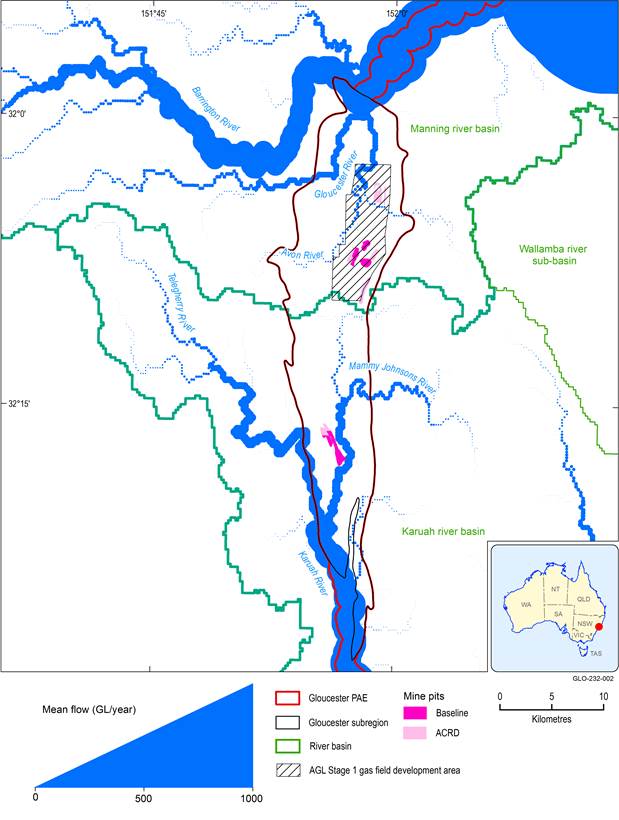
Surface water in the Gloucester subregion is topographically split into a northern and southern part, with the divide just south of the township of Stratford (see companion product 1.1 for the Gloucester subregion (McVicar et al., 2014, p. 68, Figure 26)). The watercourses of the Gloucester subregion are within subcatchments of the Manning river basin in the northern part, and the Karuah river basin in the southern part. The main rivers in the northern part are the Avon River and Gloucester River, both within the Gloucester river basin that makes up about 20% of the Manning river basin and produces about 22% of the annual flow. The PAE includes the Gloucester River downstream from the geological basin to the surface confluence with the Manning River (see companion product 1.3 for the Gloucester subregion (McVicar et al., 2015)). The main rivers in the southern part are the Mammy Johnsons River and Karuah River, both within the Karuah river basin. These comprise about 49% of the basin area and contribute about 46% of the annual flow to Port Stephens. Long-term average surface water flows have been visualised according to the techniques of McVicar et al. (2015) and are shown in Figure 7 and Figure 8 being, respectively, the broader area considering all relevant surface water connectivity with the subregion and the area zoomed to the subregion.
It is perhaps clearer in Figure 8 that in the northern part of the Gloucester subregion the streamflow contribution of the Barrington River far exceeds that of the Gloucester and Avon rivers. In the southern part, however, the upper Karuah River and Mammy Johnsons River are much more equal contributors to the streamflow further south out of the geological basin.
Long-term annual flow is estimated using water balance technique of Budyko (1974), as described by McVicar et al. (2015). The extent of the mines in the coal resource development pathway (CRDP) is the union of the extents in the baseline and in the additional coal resource development (ACRD). PAE = preliminary assessment extent
Data: PAE: Bioregional Assessment Programme (Dataset 1); surface water boundaries: Bioregional Assessment Programme (Dataset 2); mine pits: Bioregional Assessment Programme (Dataset 3; Dataset 4; Dataset 5) and AGL Stage 1 gas field development area: AGL Energy Ltd. (Dataset 6); flow volume: Bioregional Assessment Programme (Dataset 7)
Long-term annual flow is estimated using water balance technique of Budyko (1974), as described by McVicar et al. (2015). The extent of the mines in the coal resource development pathway (CRDP) is the union of the extents in the baseline and in the additional coal resource development (ACRD). PAE = preliminary assessment extent
Data: PAE: Bioregional Assessment Programme (Dataset 1); surface water boundaries: Bioregional Assessment Programme (Dataset 2); mine pits: Bioregional Assessment Programme Data (Dataset 3; Dataset 4; Dataset 5) and AGL Stage 1 gas field development area: AGL Energy Ltd. (Dataset 6); flow volume: Bioregional Assessment Programme (Dataset 7)

Product Finalisation date
- 2.3.1 Methods
- 2.3.2 Summary of key system components, processes and interactions
- 2.3.3 Ecosystems
- 2.3.4 Baseline and coal resource development pathway
- 2.3.5 Conceptual modelling of causal pathways
- Citation
- Currency of scientific results
- Acknowledgements
- Contributors to the Technical Programme
- About this technical product


