- Home
- Assessments
- Bioregional Assessment Program
- Methods
- Surface water modelling
- 7 Linkages with other modelling components
7.1 Linkages with groundwater modelling
7.1.1 Spatial domain
Since various aspects of model output need to be passed between surface water, groundwater and surface water – groundwater models, it is imperative that their spatial modelling domains be complementary. In general, it will not be possible to make predictions of impacts due to the additional coal resource development using the full suite of numerical models at locations where one or more of these components are missing. Ideally, these models should also be developed concurrently and have compatible time domains.
7.1.2 Interactions with groundwater models
The principal coupling points between surface water and groundwater models are:
- River stage heights generated by the surface water model are used to provide boundary conditions to a groundwater model.
- The exchange fluxes between groundwater and the river are calculated in the groundwater model and passed back to the surface water model as changes in baseflow generation.
In general, at the surface water modelling stage, these interactions will take place via the river system model. However, in subregions without a river model, a similar level of coupling can be achieved by accumulating grid-scale landscape model outputs to an appropriate scale.
AWRA-L has a simplified integrated groundwater modelling capability which can model lateral groundwater flows between grid cells. For application in BA, the algorithms controlling such processes are not active.
The BA groundwater modelling methodology is described in more detail by Crosbie et al. (2016).
7.1.3 Model sequencing
The groundwater models (possibly including both a regional model and an alluvial model) and the surface water models (possibly including both a landscape model and a river system model) need to pass information between each other. Considerable care is required in designing how this is achieved. This is particularly true when considering the need to run models for different levels of coal resource development and the need to accommodate the various post-processing steps.
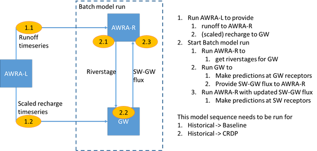
In general there will be significant differences between subregions in terms of the types of model used. The groundwater modelling in some subregions will be done using only a regional groundwater model, while in others there will also be an adjunct alluvium model. The surface water modelling will be done in some subregions using a combination of landscape and river models, while in other subregions there will be a landscape model only. Given these regional differences, it is not possible to prescribe a universal model sequencing plan. Such plans will be detailed in product 2.6.1 (surface water numerical modelling) and product 2.6.2 (groundwater numerical modelling) for each subregion or bioregion. However, a simplified coupling scheme for the case where there is a river model but no alluvium model is as depicted in Figure 9.

Figure 9 Example diagram: schematic of model run sequencing between the landscape (AWRA-L), river (AWRA-R) and groundwater models
SW = surface water; GW = groundwater; CRDP = coal resource development pathway; AWRA = Australian Water Resources Assessment system
7.2 Linkages with model node allocation
The model nodes associated with surface water provide the key output locations for surface water modelling. However, it is also important to note that streamflow will often change only slowly with distance down a river. This is particularly true in reaches with little lateral tributary inflow. This means that predicted streamflow at a single model node can often provide appropriate predictions for a range of locations along a river reach. In particular, this single set of streamflow predictions may be well within the uncertainty limits of the surface water modelling. In such environments, a single model node may prove adequate, even in quite long river reaches. It is recommended, therefore, that expert input from the surface water team be considered in allocating model nodes. In places where the density of model nodes is insufficient for receptor impact modelling, it is a reasonably trivial task to interpolate streamflows to any new model node.
7.3 Linkages with uncertainty analysis
A sensitivity analysis is conducted to assess the sensitivity of model output to variations in each of the model parameters. The most sensitive of these parameters is included in an uncertainty analysis. The uncertainty analysis is conducted using plausible ranges of values for each of the sensitive parameters using (a) a Monte Carlo procedure if there are no constraining data available or (b) a Markov chain Monte Carlo procedure when there are data to constrain the prediction.
From the surface water model, the uncertainty analysis requires estimates of the probability density function (the prior distribution) of each important model parameter. These distributions are refined from an analysis of the calibration logs for both high-flow and low-flow calibrations.
The uncertainty analysis involves the linked execution of 10,000 replicates of the groundwater and surface water models. For the surface water models, these 10,000 simulations are run on the assumption that there is no coal mining or CSG extraction in the modelling domain. The model output is modified in post-processing to account for coal resource developments in the baseline and CRDP.
The BA uncertainty analysis is described in more detail in Peeters et al. (2016).

METHODOLOGY FINALISATION DATE
- 1 Background and context
- 2 Components of surface water modelling
- 3 Streamflow modelling
- 4 River system modelling
- 5 Constituent modelling
- 6 Modelling the impacts of coal resource development
- 7 Linkages with other modelling components
- 8 Outputs from surface water modelling
- Appendix A Modifications to AWRA-R
- Appendix B Proposed structure of product 2.6.1 (surface water numerical modelling) and product 2.5 (water balance assessment)
- References
- Datasets
- Citation
- Acknowledgements
- Contributors to the Technical Programme
- About this submethodology
