2.5.1.1.1 Surface water balance
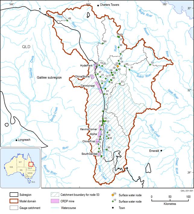
Proposed coal resource developments in the Galilee subregion that have been modelled occur in the north-flowing Belyando river basin, which comprises a part of the Burdekin river basin. The coal seam gas (CSG) and coal projects in the coal resource development pathway (CRDP) are the sum of those in the baseline and in the additional coal resource development (ACRD). The coal projects included in the additional coal resource development are: South Galilee, China First, Kevin’s Corner, Alpha, Carmichael, China Stone and Hyde Park. Because there are no coal resource developments in the baseline for the Galilee subregion, the CRDP includes only the proposed CSG and coal projects in the ACRD. There are a total of 17 proposed coal resource developments in the Galilee subregion including 14 coal mines and three CSG projects. Only seven of them (i.e. South Galilee, China First, Alpha, Kevin’s Corner, Carmichael, China Stone and Hyde Park) have sufficient data to include in surface water modelling (Figure 3). These coal resource developments are detailed in Section 1.2.3 of companion product 1.2 for the Galilee subregion (Lewis et al., 2014) and Section 2.3.4 of companion product 2.3 for the Galilee subregion (Evans et al., 2018b). Model nodes for reporting water balance have been selected to quantify the cumulative hydrological changes of coal resource development over the minimum possible area that they are all hydrologically connected and for which model outputs have been generated. In this case, surface water numerical model node 53 (Figure 3) is the upstream-most location where resultant changes of the seven modelled mines are found. The catchment of model node 53 represents a proportion of Belyando river basin intended to quantify the ‘maximum’ changes from all hydrologically connected mines in the CRDP, rather than the maximum changes around individual mines or small groupings of some mines.
Water balances for the baseline and CRDP at model node 53 have been extracted from the landscape water balance model (Australian Water Resources Assessment landscape model (AWRA-L)) for three 30-year periods (2013–2042, 2043–2072 and 2073–2102), which align with modelled temperature increases of 1.0, 1.5 and 2.0 °C under a future climate projection from the Geophysical Fluid Dynamics Laboratory (GFDL) model GFDL2.0 of global climate models (GCMs). These three time periods were generated from the 30-year historical sequence from 1983 to 2012 by modifying the historical sequence to reflect a warming trend. Thus the variability in the historical sequence is preserved, but the effect of droughts and floods does not confound the comparison between time periods. The time to maximum change will be different for different hydrological response variables and receptors, which means at the subregion level there is not a single point in time for which a maximum change water balance can be constructed. The water balance terms reported in this product represent the annual averages for each 30-year period.
Data: Bioregional Assessment Programme (Dataset 1, Dataset 2); Bureau of Meteorology (Dataset 3)
2.5.1.1.2 Conceptual groundwater balance
Unlike other bioregional assessment groundwater modelling approaches, the groundwater analytic element model outlined in companion product 2.6.2 for the Galilee subregion (Peeters et al., 2018) was not designed to estimate historical and future water balances. The main focus of the groundwater analytic element model was to simulate changes in water fluxes due to groundwater pumping as part of coal mine development. Also, it does not include information for some key groundwater balance components such as recharge. Section 2.6.2.9 in Peeters et al. (2018) details the limitations of the groundwater analytic element model approach.
A water balance was produced as an output as part of the Galilee Basin hydrogeological model (GBH), which is a regional numerical groundwater model that encompasses the whole of the Galilee subregion (Turvey et al., 2015). However, this water balance is not suitable for the purposes of the bioregional assessment for the following reasons:
- It encompasses the whole of the Galilee subregion, and not just that part of the Burdekin river basin (specifically the Belyando river basin) that lies within the Galilee subregion where changes to groundwater are likely to occur.
- The area used to define the groundwater water balance for this product needs to have some congruence with areas where the surface water modelling (in companion product 2.6.1 (Karim et al., 2018)) and groundwater modelling (in companion product 2.6.2 (Peeters et al., 2018)) predicts change.
- The GBH model is a complex regional groundwater model produced in a very short time period and within a limited budget. Upon completion, a number of limitations and issues have been identified by the contractors – HydroSimulations – and reviewers from Queensland Government, Office of Water Science and relevant project and discipline leads from the bioregional assessment (Peeters et al., 2018). Some of the known issues would also affect the water balance that was output from the GBH numerical model.
- The GBH numerical model does not have stochastic outputs. It is a deterministic model that includes a water balance summary as an output.
As an alternative, a conceptual groundwater balance was developed in order to compare baseline conditions (pre-mining) with a period 30 years in the future that assumes full development of the seven coal mines in the modelled CRDP. This conceptualised groundwater balance focuses on the portion of the Galilee subregion that falls within the Burdekin river basin (Figure 3). Because of the lack of data, it is not possible to model the water balance for the same three future time periods to the same degree as was undertaken for the surface water balance (Section 2.5.1.1.1).
The approach taken is a modified version of the water cycle report defined for the Water Accounting Stocktake project undertaken by the inter-jurisdictional National Water Initiative Committee (SKM, 2006). While this is a relatively simple modelling approach that does not produce stochastic outputs for uncertainty analysis, it is considered fit for purpose for this BA as it can flag if there is potential for groundwater pumping by coal mining operations to cause changes to a major component of the groundwater balance, as well as identify possible data gaps.
The conceptual groundwater balance consists of several components. These are:
Baseflow can be derived from a number of processes (for further detail see Section 2.1.5.2 in companion product 2.1-2.2 for the Galilee subregion (Evans et al., 2018a)). However, for the purposes of the conceptual water balance, baseflow is assumed to be derived through fully saturated groundwater discharge from an aquifer to surface drainage. This may provide a theoretical upper estimate of the potential fluxes of groundwater that may occur between river reach and an underlying aquifer.
The conceptual groundwater balance assumes that prior to the drilling of groundwater bores, the groundwater system was in a steady-state condition with inputs equal to outputs. Thus prior to development of coal and CSG resources in the region:
Rainfall recharge + surface water recharge = Evapotranspiration + baseflow + spring discharge + groundwater flow out of the modelling area.
Therefore values, around which there are low levels of confidence, such as evapotranspiration and groundwater flow out of the modelling area, are determined by balancing the above equation with parameters around which there may be higher levels of confidence such as groundwater recharge, spring discharge and baseflow.
Because the conceptual groundwater balance is based on published estimates of water balance components, it is not possible to report using the three 30-year time periods as used in the surface water balance (Section 2.5.1.1.1) and other bioregional assessments. The groundwater balance was undertaken to compare the results under the baseline (a future where no coal resource developments occur) to results under the modelled CRDP (a future where additional coal resource developments occur). Section 2.3.4 of companion product 2.3 (Evans et al., 2018b) provides more detail on the modelled CRDP for the Galilee subregion.
Full references for each item in the groundwater balance along with estimates of data currency and reliability are available in Bioregional Assessment Programme (Dataset 1).
