Breadcrumb
The development of the PAE for the Pedirka subregion was carried out by South Australian Department of Environment, Water and Natural Resources and only a summary of their work is provided in this section.
The following assumptions were applied to define the PAE for the Pedirka Basin:
- The extent of potential groundwater drawdown was derived from DEWNR groundwater Stage 1 preliminary modelling for the Pedirka Basin.
- Due to the absence of short-term (seven years) viable CSG or coal developments in SA, specific potential mining locations were not considered, other than known exploration activities occurring in the PAE.
- Exploration lease areas were included to determine known and potential mining activities, as these covered all mapped coal resources for the Pedirka Basin.
- Exploration lease areas do not specifically include potential mining-related infrastructure corridors, such as pipelines and access roads outside of the mining lease boundaries.
- As a result of dewatering activities, open-cut coal mining has the potential to draw down water in the Great Artesian Basin (GAB) where accessed coal deposits lie below the level of the aquifer.
- McDills Anticline was excluded from the modelling assessment due to poorly characterised geological structure. Further investigations are required to understand the influence on water availability and transmission extent.
- Northern boundary of the Perdirka PAE was based upon GAB boundary and extent of potential drawdown within the basin.
- Groundwater flows from recharge areas in the GAB towards critical spring supergroups, but drawdown would not be sufficient to impact the Mulligan River springs, near Boulia in Queensland, as these are outside of the GAB.
- There is no surface water connectivity to the isolated dune lake systems in the south and east of the Pedirka subregion in the Simpson Desert.
- Surface water features of the Finke River catchment within the Pedirka (PAE) boundary were included, but upstream connections of the tablelands were excluded as frequency of connectivity was considered too low for upstream refuge ecosystems to be reliant on lower reaches within the Pedirka Basin.
- The Neales River catchment was derived from the 1-second national digital elevation model and smoothed manually using heads-up digitising. Where possible it follows existing basin boundaries.
The following methodology was used to formulate the Pedirka PAE:
- The geological Pedirka Basin boundary and the mapped areas of economic coal beds and lodged exploration licences (obtained from SA Department of State Development (DSD)) were used as the starting point for calculations.
- A potentiometric surface was generated for the GAB aquifer (Cadna-owie Formation – Algebuckina Sandstone and equivalents) within SA and NT.
- DEWNR modelling of possible large-scale mining operations in the Pedirka subregion of the Eromanga Basin (based on exploration licences), with assumptions of 50-year life of mine and approximately around 400 ML withdrawal of groundwater per day, generated an inferred 210 km groundwater drawdown extent to 1 m drawdown.
- Western and southern boundaries were extended to follow the GAB and Arckaringa Basin boundaries to allow for any potential groundwater connectivity in these areas.
- A 10 km buffer was included where the calculated boundary intersects with fractured rock aquifer (FRA) extents.
- Paleogene and Neogene sediments were excluded from consideration as a buffer to the GAB where they intersect with coal deposits, as it was assumed that only direct impact to these Ceonzoic sediments would occur should open-cut mining activities occur.
- Phreatic surface information was utilised to identify connectivity to shallow groundwater potentially utilised by vegetation (defined as groundwater at up to 10 m depth).
- GAB discharge springs of the Lake Eyre supergroup were included, along with a 5 km buffer around the point location in order to accommodate the extensive wetland and terrestrial ecosystems that the springs support.
- Dalhousie Springs Complex is within the 210 km drawdown extent.
- Lower reaches of the Finke River are all within the 210 km buffer around the Pedirka coal beds, including the Snake Gully / Finke River floodout.
- All of the catchment of the Macumba River was incorporated into the PAE, including subcatchments that lie outside the Pedirka PAE boundary and those downstream to the confluence with the Kallakoopah.
- Upstream subcatchments of the Neales-Peake outside of the inferred 210 km drawdown zone were also included on the basis that some of the springs in those subcatchments support critical refuges for aquatic species that inhabit upstream reaches.
- A 20 km buffer boundary was used as a contingency around all known surface waters and groundwater drawdown extents, although all watercourse buffers were confined to within the groundwater drawdown extent.
The following data gaps were identified during definition of the Pedirka PAE:
- Exploration licences were not available for the NT.
- Further information and modelling are required to understand the zone of potential groundwater drawdown influence to 0.1 m. Such additional modelling might lead to extension of the zone of potential influence further south and east to encompass springs in the Lake Eyre and Mulligan River supergroups.
- Based on current level of knowledge, in the north-east portion of the Pedirka PAE, there is GAB flow towards the Mulligan River supergroup of springs, which are EPBC Act-listed discharge springs. These are currently assumed to be recharged from flow in rivers in this region. There is a possibility that a reduction in pressure of the GAB within the PAE could reverse the flow paths away from the Mulligan River springs or reduce pressure to them. For the current analysis, due to the depths of Paleogene and Neogene sediments and distance from the coal beds, these possibilities have been excluded due to the low likelihood of hydrological connectivity. Further research on hydrogeology in this region should inform future decision to include or exclude these springs.
- The influence of the Macumba River on Kati Thanda – Lake Eyre is unclear; further research is required.
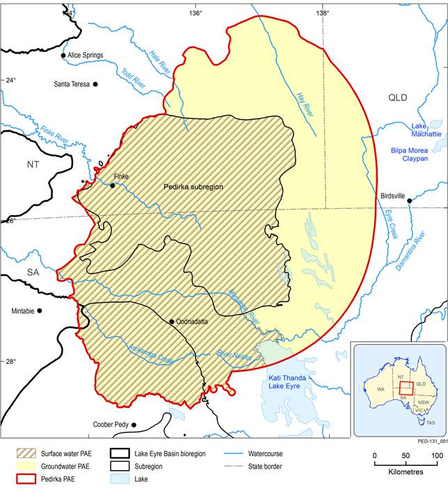
Figure 3 Surface and groundwater preliminary assessment extents (PAE) for the Pedirka subregion
Last updated:
28 September 2018

Summary and download
Product Finalisation date
2015
PRODUCT CONTENTS
ASSESSMENT
ASSESSMENT COMPONENT