- Home
- Factsheets
- Coal resource development and water resources in the Pedirka subregion

At a glance
There is limited potential for coal mining in the Pedirka subregion, due to the remoteness and depths of coal in the geological Pedirka Basin and the consequent lack of data. There may be potential for coal seam gas extraction in the eastern part of the basin, but exploration is at an early stage. Research shows possible connection between parts of the eastern Pedirka Basin and the overlying Great Artesian Basin.
What are the coal and coal seam gas resources?
There is coal in the rocks of the Pedirka Basin, which underlies the subregion, but as of July 2015 when this assessment was completed, there were no coal mines or commercial coal seam gas fields operating in the subregion.
The coal in the Pedirka Basin is too deep for coal mining. There may be potential for coal seam gas development in the eastern Pedirka Basin and there has been some exploration in this part of the subregion. Coal in the western part of the basin has not been buried deep and long enough to generate sufficient volumes of coal seam gas for commercial extraction.
What did the assessment find?
The assessment has improved our understanding of the Pedirka Basin through the development of the first hydrogeological (groundwater and geology) map of the Basin. A variety of field techniques including geophysics, aquifer pumping tests and water chemistry analysis have confirmed that parts of the eastern Pedirka Basin may be connected to the Great Artesian Basin.
New information on the location of recharge areas and the inflow volumes into the groundwater system has improved our understanding of how the groundwater moves through the Pedirka Basin. This includes the basin’s relative contribution to the spring flows in the Witjira-Dalhousie Springs complex. A modelled mine dewatering scenario in the Pedirka Basin showed that coal resource development (if it occurred) could affect the nationally important Witjira-Dalhousie Springs complex. This is due to the Springs’ proximity to the edge of the Pedirka Basin.
How was the assessment done?
Scientists used the best available data to describe coal and coal seam gas resources, surface water and groundwater resources. Local experts, including Natural Resources SA Arid Lands, local councils, and community groups, provided information on water-dependent assets, such as wetlands and bores that rely on surface water or groundwater. A register of these assets is available for use in future assessments.
The scientific findings of three projects by the South Australian Government as part of the Bioregional Assessment Program informed this assessment. These projects (Lake Eyre Basin Rivers Monitoring Project, Arckaringa Basin and Pedirka Basin Groundwater Assessment and Lake Eyre Basin Springs Assessment) investigated surface water and groundwater in the coal basins in the Lake Eyre Basin bioregion, including the Pedirka subregion.
How will information from the assessment be used?
The data and tools from this assessment are available to support natural resource management in the Pedirka subregion. Existing and newly acquired data on the characteristics of springs was formatted consistently so that datasets are more easily comparable across state boundaries. Information from the assessment can be used in future assessments and environmental studies.
Results from this assessment are provided in a contextual report, a water-dependent asset register and a data register at www.bioregionalassessments.gov.au/assessments/pedirka-subregion. The website includes links to work by the South Australian Government as part of the Bioregional Assessment Program. It also provides open access to the methods and datasets used to develop the assessment. Data from a range of disciplines are provided under a Creative Commons Attribution license where possible on the Australian Government’s public data information service www.data.gov.au.

Where is the Pedirka subregion?
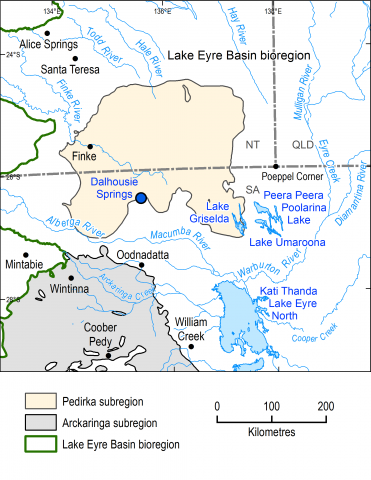
The Pedirka subregion is in the Northern Territory and South Australia and is one of four subregions within the Lake Eyre Basin bioregion. The Pedirka subregion is defined by the known extent of the geological Pedirka Basin, which is mostly buried deep below younger rocks such as those of the Eromanga Basin.
